geo.wikisort.org - Coast
Robbery Beaches are beaches extending along the north side of Byers Peninsula, Livingston Island in the South Shetland Islands, Antarctica between Essex Point to the west and Nedelya Point to the east. They are crossed by Eridanus Stream and Bedek Stream.


The name ‘Robbery Beach’ was used by James Weddell in 1820–23. It arose from the English robbery of sealskins collected by the American brig Charity (Capt. Charles H. Barnard) of New York in January 1821. There was fierce competition between British and American sealers in the area during the early 1820s.
Location
The beaches are centred at 62°36′57.6″S 61°04′58.8″W (British mapping in 1968, detailed Spanish mapping in 1992, and Bulgarian mapping in 2005 and 2009).
Maps
- Chart of South Shetland including Coronation Island, &c. from the exploration of the sloop Dove in the years 1821 and 1822 by George Powell Commander of the same. Scale ca. 1:200000. London: Laurie, 1822
- Península Byers, Isla Livingston. Mapa topográfico a escala 1:25000. Madrid: Servicio Geográfico del Ejército, 1992. (Map image on p. 55 of the linked study)
- L.L. Ivanov et al. Antarctica: Livingston Island and Greenwich Island, South Shetland Islands. Scale 1:100000 topographic map. Sofia: Antarctic Place-names Commission of Bulgaria, 2005.
- L.L. Ivanov. Antarctica: Livingston Island and Greenwich, Robert, Snow and Smith Islands. Scale 1:120000 topographic map. Troyan: Manfred Wörner Foundation, 2009. ISBN 978-954-92032-6-4
- Antarctic Digital Database (ADD). Scale 1:250000 topographic map of Antarctica. Scientific Committee on Antarctic Research (SCAR). Since 1993, regularly upgraded and updated.
- L.L. Ivanov. Antarctica: Livingston Island and Smith Island. Scale 1:100000 topographic map. Manfred Wörner Foundation, 2017. ISBN 978-619-90008-3-0
In fiction
Robbery Beaches are part of the mise-en-scène in the Antarctica thriller novel The Killing Ship authored by Elizabeth Cruwys and Beau Riffenburgh under their joint alias Simon Beaufort in 2016, and are shown on a sketch map of Livingston Island illustrating the book.[1][2]
Gallery
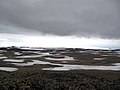 Eastern Byers Peninsula in Livingston Island with left to right Lair Hill, Robbery Beaches, Sparadok Point, Tsamblak Hill and Negro Hill in the middle ground; and Rowe Point, Cutler Stack, Ivanov Beach, Nedelya Point, Urvich Wall surmounted by the slopes of Rotch Dome, and Clark Nunatak in the background
 Topographic map of Antarctic Specially Protected Area ASPA 126 Byers Peninsula
 Fragment of George Powell's 1822 chart of the South Shetland Islands and South Orkney Islands featuring Robbery Beaches (as 'North Beach')
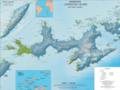 Topographic map of Livingston Island and Smith Island
 Geography of the novel
The Killing Ship by Simon Beaufort


Notes
- S. Beaufort. The Killing Ship. Sutton, Surrey: Severn House Publishers, 2016. 224 pp. ISBN 978-0-7278-8639-2
- The Killing Ship. Susanna Gregory Website, 2019
References
- Robbery Beaches. SCAR Composite Antarctic Gazetteer.
![]() This article incorporates public domain material from the United States Geological Survey document: "Robbery Beaches". (content from the Geographic Names Information System)
This article incorporates public domain material from the United States Geological Survey document: "Robbery Beaches". (content from the Geographic Names Information System)
This Livingston Island location article is a stub. You can help Wikipedia by expanding it. |
Другой контент может иметь иную лицензию. Перед использованием материалов сайта WikiSort.org внимательно изучите правила лицензирования конкретных элементов наполнения сайта.
WikiSort.org - проект по пересортировке и дополнению контента Википедии