geo.wikisort.org - Coast
Tankerton (formerly Tankerton-on-Sea) is a suburb of Whitstable in Kent in south-east England. It was designed in the late 19th century as the train network brought holidaymakers to the sea. It gives its name to a ward of Canterbury City Council.
| Tankerton | |
|---|---|
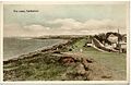
 Tankerton beach on the borders of Swalecliffe | |
 Tankerton Location within Kent | |
| Population | 4,613 (2011)[1] |
| OS grid reference | TR120669 |
| District | |
| Shire county |
|
| Region | |
| Country | England |
| Sovereign state | United Kingdom |
| Post town | Whitstable |
| Postcode district | CT5 |
| Dialling code | 01227 |
| Police | Kent |
| Fire | Kent |
| Ambulance | South East Coast |
| UK Parliament |
|
History
The place-name 'Tankerton' is first attested in The Book of Fees for 1242, where it appears as Tangrenton. The name means 'the town or settlement of Tancred's people'.[2]
Tankerton-on-Sea was a commercial development by the Tankerton Estate Company in the late 19th century, and was designed with a grid of streets leading from the shoreline. In 1890 the Tankerton Estate, including Tankerton Tower (now known as Whitstable Castle) was purchased for development by Charles Newton-Robinson, a road was built, the land was divided into plots and sold at auctions.[3] The Tankerton Estates still exist and are managed by County Estate Agents in Whitstable.
Formerly Tankerton's coastline included a small pier, built in 1894, but this no longer exists having been demolished in the 1910s.[4][5]
In July 2018, the wreck of a Tudor era merchant ship appeared in the sand.[6] One timber of her hull was felled in 1531. She measures 12m x 5m, and had a capacity of 100 to 200 tons. She is thought to have been in the Copperas trade. The wreck was discovered by local history volunteers, who reported it to Historic England. They commissioned a report from Wessex Archaeology. The government has now listed the vessel as the only wreck of its kind in south-east England.[7]
Environment
The slopes to the shore are a site of special scientific interest (SSSI) because they support the largest single population of the large umbellifer hog's fennel (Peucedanum officinale) in Britain.[8] Tankerton has a Blue Flag beach and a Seaside Award, certified for high environmental standards.[9][10]
Economy
The economy is based around tourism. The little wooden beach huts at the base of the slopes are currently highly desirable, and notable owners have included Tracey Emin, who sold hers to Charles Saatchi for £75,000.[11] Seaview Caravan Holiday Park adjoins Tankerton, and formerly also contained a large number of chalets, as well as static caravans and camping. It is one of the largest holiday parks on the North Kent coast
Demography
At the 2001 UK census, the Tankerton electoral ward had a population of 4583. The ethnicity was 98.7% white, 0.4% mixed race, 0.6% Asian, 0.2% black and 0.1% other. The place of birth of residents was 95.3% United Kingdom, 0.7% Republic of Ireland, 1.3% other Western European countries, and 2.7% elsewhere. Religion was recorded as 80.2% Christian, 0.4% Buddhist, 0% Hindu, 0.1% Sikh and 0.2% Muslim. 12% were recorded as having no religion, 0.4% had an alternative religion and 6.6% did not state their religion.[12]
The economic activity of residents aged 16–74 was 34.3% in full-time employment, 12.6% in part-time employment, 11.3% self-employed, 1.9% unemployed, 2.2% students with jobs, 3.2% students without jobs, 22.3% retired, 5.8% looking after home or family, 4% permanently sick or disabled and 2.4% economically inactive for other reasons. The industry of employment of residents was 17% retail, 10.9% manufacturing, 8.2% construction, 9.9% real estate, 13% health and social work, 13.2% education, 6.9% transport and communications, 5.9% public administration, 4.2% hotels and restaurants, 4% finance, 1.2% agriculture and 5.6% other. Of the ward's residents aged 16–74, 20.6% had a higher education qualification or the equivalent, compared with 19.9% nationwide.[12]
Gallery
 Tinted photograph on postcard dated around 1905-1914 showing "The Leas"
 All Saints' Church
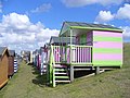 Colourful rows of wooden huts on the grassy slopes of "Tankerton slopes" below Marine Parade


See also
References
- "Whistable Ward population 2011". Retrieved 2 October 2015.
- Eilert Ekwall, The Concise Oxford Dictionary of English Place-names, p.460.
- Green, John W.; Money, Robin A. (7 August 2013). Exploring the History of Lee-on-the-Solent. Andrews UK Limited. ISBN 978-1-909183-32-2.
- Office, United States Hydrographic (1917). British Islands Pilot: East coasts of Scotland and England from Fife Ness to North Foreland, including the Firth of Forth and the Thames and Medway Rivers. Hydrographic Office under the authority of the Secretary of the Navy. p. 402.
- Geocaching. "Geocaching - The Official Global GPS Cache Hunt Site". geocaching.com. Retrieved 14 April 2022.
- "'Incredible' Tudor shipwreck discovered in Kent given protection". Sky News. Retrieved 16 July 2018.
- Kennedy, Maev (15 July 2018). "Tudor shipwreck discovered by local group on Kent beach". The Guardian. Retrieved 16 July 2018.
- "Natural England - SSSIs : Introduction". English-nature.org.uk. Retrieved 18 March 2012.
- "Tankerton, England - Beach". Blue Flag. Foundation for Environmental Education. Retrieved 6 February 2022.
- Davies, Robert. "Award winning beaches are ready for a busy summer". Canterbury Newsroom. Retrieved 3 June 2022.
- Lynne Wallis (28 July 2003). "A little place beside the sea". Evening Standard. London. Retrieved 10 October 2016.
- "Neighbourhood Statistics". Statistics.gov.uk. Retrieved 21 February 2008.
External links
Towns and villages in the Canterbury district of Kent, England | ||
|---|---|---|
 |
| |
| ||
Другой контент может иметь иную лицензию. Перед использованием материалов сайта WikiSort.org внимательно изучите правила лицензирования конкретных элементов наполнения сайта.
WikiSort.org - проект по пересортировке и дополнению контента Википедии