geo.wikisort.org - Coast
Tamandarë (Brazilian Portuguese: Tamandaré; Old Tupi: Tamandûaré, lit. "different") is a coastal municipality about 103 km (64 mi) south of Recife, the capital city of the Brazilian state of Pernambuco.


Tamandaré | |
|---|---|
Municipality | |
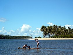
 Tamandaré Fishermen | |
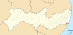
 Location in Pernambuco | |
 Tamandaré Location in Brazil | |
| Coordinates: 8.76°S 35.105°W | |
| Country | Brazil |
| State | Pernambuco |
| Municipality | Tamandaré |
| Area | |
| • Total | 190 km2 (70 sq mi) |
| Population (2020 [1]) | |
| • Total | 23,623 |
| • Density | 120/km2 (320/sq mi) |
| Time zone | UTC−3 (BRT) |
Geography
- State - Pernambuco
- Region - Zona da mata Pernambucana
- Boundaries - Rio Formoso and Sirinhaém (N); Barreiros (S); Água Preta (W); Atlantic Ocean (E)
- Area - 190 square kilometres (73 sq mi)
- Elevation - 8 m
- Vegetation - Coconut trees and Atlantic forest
- Clima - Hot tropical and humid
- Annual average temperature - 25.3 c
- Distance to Recife - 103 km
The municipality contains part of the strictly protected Saltinho Biological Reserve, a 562 hectares (1,390 acres) conservation unit created in 1983.[2]
Beaches
- Tamandaré beach
Urbanized, has two kilometers long of sand and a number of tourist facilities. Has small waves and fine sand. Easy to reach from Recife and Caruaru.
- Boca da Barra beach
At low tide is formed natural pools. Suitable for swimming, has a dense mangrove vegetation in the estuary of Canoa quebrada River. Its possible to reach the Mamocambilhas beach in Barreiros by walking.
- Campas beach
Three kilometers long, is good for swimming, and in front of the Marinas hotel, the sea allows natural anchorages of boats. It is possible to rent equipment such as jetski, banana boats and boats.
- Carneiros beach
Still almost deserted, just has a few summer houses and bars. It has five kilometers of landscape mixed between the reefs, coconut trees and low waves water.
Economy
The main economic activities in Tamandaré are based in tourism, artisanal fishing, food and beverage industry and agriculture especially coconuts.
Economic Indicators
| Population [3] | GDP x(1000 R$).[4] | GDP pc (R$) | PE |
|---|---|---|---|
| 18,999 | 79,461 | 4,381 | 0.137% |
Economy by Sector 2006
| Primary sector | Secondary sector | Service sector |
|---|---|---|
| 7.44% | 23.98% | 68.58% |
Health Indicators
| HDI (2000) | Hospitals (2007) | Hospitals beds (2007) | Children's Mortality every 1000 (2005) |
|---|---|---|---|
| 0.596 | 1 | 17 | 19.2 |
References
- IBGE 2020
- Unidade de Conservação: Reserva Biológica de Saltinho (in Portuguese), MMA: Ministério do Meio Ambiente, retrieved 2016-04-17
- http://www.ibge.gov.br/home/estatistica/populacao/estimativa2009/POP2009_DOU.pdf IBGE Population 2009 Tamandare, page 35]
- Tamandare 2007 GDP IBGE page 32 Archived 2016-03-04 at the Wayback Machine
- PE State site - City by city profile
На других языках
- [en] Tamandaré
[es] Tamandaré
Tamandaré es un municipio del litoral sur del estado de Pernambuco, en la Región Nordeste de Brasil. Pertenencia a la Región Geográfica Intermediaria del Recife y a la Región Geográfica Inmediata de Barreiros-Sirinhaém, localizándose a 109 kilómetros a sur de la capital pernambucana. Tiene una población estimada al 2020 de 23.623 habitantes.[1][ru] Тамандаре (Пернамбуку)
Тамандаре (порт. Tamandaré) — муниципалитет в Бразилии, входит в штат Пернамбуку. Составная часть мезорегиона Мата-Пернамбукана. Входит в экономико-статистический микрорегион Мата-Меридиунал-Пернамбукана. Население составляет 18 081 человек на 2007 год. Занимает площадь 190 км². Плотность населения — 95 чел./км².Другой контент может иметь иную лицензию. Перед использованием материалов сайта WikiSort.org внимательно изучите правила лицензирования конкретных элементов наполнения сайта.
WikiSort.org - проект по пересортировке и дополнению контента Википедии
