geo.wikisort.org - Coast
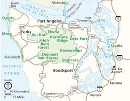
The Olympic Peninsula is a large arm of land in western Washington that lies across Puget Sound from Seattle, and contains Olympic National Park. It is bounded on the west by the Pacific Ocean, the north by the Strait of Juan de Fuca, and the east by Hood Canal. Cape Alava, the westernmost point in the contiguous United States, and Cape Flattery, the northwesternmost point, are on the peninsula. Comprising about 3,600 square miles (9,300 km2), the Olympic Peninsula contained many of the last unexplored places in the contiguous United States. It remained largely unmapped until Arthur Dodwell and Theodore Rixon mapped most of its topography and timber resources between 1898 and 1900.[1]
This article needs additional citations for verification. (October 2019) |


Geography
Clallam and Jefferson Counties, as well as the northern parts of Grays Harbor and Mason Counties, are on the peninsula. The Kitsap Peninsula, bounded by the Hood Canal and Puget Sound, is an entirely separate peninsula and is not connected to the Olympic Peninsula.
From Olympia, the state capital, U.S. Route 101 runs along the Olympic Peninsula's eastern, northern, and western shorelines.
The Olympic mountain range sits in the center of the Olympic Peninsula. This range is the second largest in Washington State. Its highest peak is Mt. Olympus.
A major effort called the Wild Olympics campaign is under way to protect additional wilderness areas on the Olympic Peninsula, protect salmon streams under the Wild and Scenic River Act and provide a means for Olympic National Park to offer to buy land adjacent to the Park from willing sellers.
Climate

Most of the peninsula has an oceanic climate, or Cfb under the Köppen climate classification. Most populated areas, however, have a warm-summer Mediterranean climate, or Csb.
The Olympic Peninsula is home to temperate rain forests, including the Hoh, Queets Rain Forest, and Quinault. Rain forest vegetation is concentrated primarily in the western part of the peninsula, as the interior mountains create a rain shadow effect in areas to the northeast, resulting in a much drier climate in those locales.
Rivers
Major salmon-bearing rivers on the Olympic Peninsula include, clockwise from the southwest, the Humptulips, the Quinault, the Queets, the Quillayute, Bogachiel, the Sol Duc, the Lyre, the Elwha (see Elwha Ecosystem Restoration), the Dungeness, the Dosewallips, the Hamma Hamma, the Skokomish, and the Wynoochee River.
Lakes
Natural lakes on the peninsula include Lake Crescent, Lake Ozette, Lake Sutherland, Lake Quinault, and Lake Pleasant. Two dammed rivers form the reservoirs of Lake Cushman and Wynoochee Lake; two previous reservoirs, destroyed in the Elwha Ecosystem Restoration were Lake Aldwell (behind the former Elwha Dam) and Lake Mills (behind the former Glines Canyon Dam).
Parks
The peninsula contains many state and national parks, including Anderson Lake, Bogachiel, Dosewallips, Fort Flagler, Fort Worden, Lake Cushman, Mystery Bay, Old Fort Townsend, Potlatch, Sequim Bay, Shine Tidelands, and Triton Cove state parks; Olympic National Park; and the Olympic National Forest. Within the Olympic National Forest, there are five designated wilderness areas: The Brothers, Buckhorn, Colonel Bob, Mt. Skokomish, and Wonder Mountain. Just off the west coast is the Washington Islands Wilderness.
Politics
The Olympic Peninsula is represented in the U.S. House of Representatives by Democrat Derek Kilmer. It is represented in the Washington State Legislature by Democratic state senator Kevin Van De Wege and Democratic state representatives Mike Chapman and Steve Tharinger.
Gallery
 Cedar Creek and Abbey Island, Kalaloch Area
 Hoh River
 National Park Service Sign at the entrance of Hoh Rain Forest
 Hurricane Ridge
 Lake Crescent
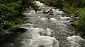 Elwha River
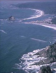
 Point of the Arches
 A foggy day at Hurricane Ridge
 Mount Constance


Cities and towns in the Olympic Peninsula
Population of at least 10,000
- Port Angeles
- Aberdeen
Population of at least 5,000
- Hoquiam
- Ocean Shores
- Port Townsend
- Sequim
Population of at least 1,000
- Forks
- Port Hadlock
- Port Ludlow
Population of less than 1,000
- Amanda Park
- Brinnon
- Chimacum
- Clallam Bay
- Discovery Bay
- Eldon
- Hoodsport
- Humptulips
- Kalaloch
- La Push
- Lilliwaup
- Moclips
- Neah Bay
- Ocean City
- Ozette
- Pacific Beach
- Potlatch
- Quilcene
- Quinault
- Sekiu
- Union
References
- Majors, Harry M. (1975). Exploring Washington. Van Winkle Publishing Co. p. 71. ISBN 978-0-918664-00-6.
External links
 Olympic Peninsula travel guide from Wikivoyage
- Olympic National Park
- University of Washington Libraries Digital Collections – The Pacific Northwest Olympic Peninsula Community Museum A web-based museum showcasing aspects of the rich history and culture of Washington State's Olympic Peninsula communities. Features cultural exhibits, curriculum packets and a searchable archive of over 12,000 items that includes historical photographs, audio recordings, videos, maps, diaries, reports and other documents.
- Olympic Peninsula at Curlie
- PBS - Scraping together Mt. Olympus - Nick on the Rocks on YouTube
Olympia (capital) | |||||||
| Topics |
|  | |||||
| Society |
| ||||||
| Politics |
| ||||||
| Regions |
| ||||||
| Largest cities |
| ||||||
| Counties |
| ||||||
| |||||||
Authority control | |
|---|---|
| National libraries | |
| Other | |
На других языках
[de] Olympic-Halbinsel
Die Olympic-Halbinsel (englisch Olympic Peninsula) ist eine Halbinsel im Nordwesten des US-Bundesstaates Washington. Sie ist im Westen vom Pazifischen Ozean, im Norden von der Juan-de-Fuca-Straße und im Osten vom Puget Sound umgeben. Im Süden gilt der Chehalis River als Grenze der Halbinsel. Am Puget Sound, gegenüber der Halbinsel liegt Seattle, die größte Stadt der Region, im Südosten Olympia, Washington, die Hauptstadt des Bundesstaates.- [en] Olympic Peninsula
[ru] Олимпик (полуостров)
Олимпик (англ. Olympic Peninsula) — полуостров в Северной Америке, занимающий запад и северо-запад штата Вашингтон, находится к северо-западу от столицы штата Олимпия и к западу от Сиэтла.Другой контент может иметь иную лицензию. Перед использованием материалов сайта WikiSort.org внимательно изучите правила лицензирования конкретных элементов наполнения сайта.
WikiSort.org - проект по пересортировке и дополнению контента Википедии