geo.wikisort.org - Coast
The Oleta River State Park is a 1,043-acre (422 ha) state park on Biscayne Bay in the municipal suburb of North Miami in metropolitan Miami, Florida. Adjoining the Biscayne Bay Campus of Florida International University, the park contains one of the largest concentrations of Casuarina trees (Australian 'pine'), an invasive species in the state park system.
This article needs additional citations for verification. (September 2015) |
| Oleta River State Park | |
|---|---|
IUCN category IV (habitat/species management area) | |
 Entrance sign to Oleta River State Park | |
  | |
| Location | North Miami, Miami, Florida, United States |
| Coordinates | 25°55′08″N 80°08′24″W |
| Area | 1,043 acres (4.22 km2) |
| Created | 1986 |
| Governing body | Florida State Parks |
| Website | Oleta River State Park |
Facilities
The central feature of this park is the mouth of the Oleta River, for which it is named. The river has drawn human inhabitants to the area since about 500 B.C, when its shores served as a campground for Tequesta Indians. It was used by U.S. troops (who called it Big Snake Creek) in 1841 during the Second Seminole War, and further explored in 1881 by Naval Captain William Hawkins Fulford, whose ventured inland to what is now the city of North Miami Beach. The area became more heavily settled in the 1890s and in 1922, developers changed the name from Big Snake Creek to the Oleta River.
The river itself no longer flows to the Everglades, but remains a popular area for canoeing. The park also boasts some of the best wilderness bike trails in the country, and is a frequent host for triathlons and other extreme sports events. There is a beach on Biscayne Bay, kayak rentals, and primitive cabins. Oleta River State Park is also the headquarters to one of the state's five AmeriCorps Florida State Parks chapters.
Health concerns
Oleta River State Park is adjacent to Munisport landfill, a former superfund site. However, no health issues at Oleta River state park have been linked to the landfill.[1]
Gallery
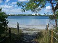 Path to beach
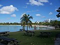 Picnic area by beach
 Picnic area and pier
 Picnic area and paths
 Cocoplum growing in Oleta River State Park - Fruit and branches
 Detail of branches
 Mature and immature fruits
 Marsh and Mangroves
 Mangroves
 Sabal Palm growing in the park
 Wild Lantana flowers growing
 Wild lantana growing near road leading to entrance to park
 General view of beach
 Underview of bridge leading to the park
 View of barrier underneath bridge to protect pilons
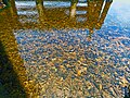 View of water with sediments and oyster beds underneath Oleta River bridge


See also
External links
- Oleta River State Park at Florida State Parks
- Oleta River State Recreation Area at Absolutely Florida
- Oleta River State Recreation Area at Wildernet
- Oleta River State Park Mountain Bike Trail at Dirtworld.com
References
- "Public Health Assessment, Munisport Landfill, North Miami, Dade County, Florida". Retrieved 2007-07-28.
Protected areas of Florida | |||||||||||||||||||||||
|---|---|---|---|---|---|---|---|---|---|---|---|---|---|---|---|---|---|---|---|---|---|---|---|
| |||||||||||||||||||||||
| |||||||||||||||||||||||
| |||||||||||||||||||||||
| Central business district |
|
|---|---|
| Major urban areas | |
| Colleges and universities |
|
| Parks and recreation |
|
| Attractions |
|
| Major shopping centers |
|
| Transportation |
|
| Major thoroughfares |
|
| |
Другой контент может иметь иную лицензию. Перед использованием материалов сайта WikiSort.org внимательно изучите правила лицензирования конкретных элементов наполнения сайта.
WikiSort.org - проект по пересортировке и дополнению контента Википедии