geo.wikisort.org - Coast
Norah Head, originally known as Bungaree Noragh Point,[1] is a headland on the Central Coast, New South Wales, Australia, south of Newcastle and north of Sydney. The nearest suburbs are Noraville, Canton Beach and Toukley. Soldiers Beach is located in Norah Head. The suburb is home to a lighthouse with scenic views, which is also considered a venue for weddings. The Norah Head tidal rock pool next to the Cabbage Tree harbour is a popular destination for families with young children due to its sheltered location.[2]
Norah Head
Bungaree Noragh Point | |
|---|---|
 Norah Head lighthouse, located on the headland | |
 Norah Head Location in New South Wales | |
| Coordinates: 33°16′57″S 151°34′27″E | |
| Country | Australia |
| State | New South Wales |
| Municipality | Central Coast Council |
Lighthouse
The Norah Head Lighthouse was the last significant lighthouse built in New South Wales, a 27-metre (89 ft) tower, completed in 1903 with monetary assistance from the Hargraves family of Noraville after considerable numbers of ships foundered on the coast near the headland. Originally it was powered by a kerosene concentric wick lamp and still today it features a second order bivalve Fresnel lens[3] prism floating on a mercury bath. At first, the prism was rotated by descending weights, but the light was electrified in 1961 and fully automated in 1995. The light flashes once in 15 seconds, and is visible to 27 nautical miles (50 km), the focal plane is located at 46 metres (151 ft) AHD . For coastal shipping, two additional light signals are shown: a red light in the northeast sector, emitted from 39 metres (128 ft) above the sea and a green one towards southwest, emitted from 44 metres (144 ft); both are continuous.[3]
The former lighthouse keepers cottage (Head Keeper's separate cottage and two assistants semi-detached quarters) are maintained, and two of these are available for rent.[4]
Heritage listings
Norah Head has a number of heritage-listed sites, including:
- Bush Street: Norah Head Lightstation Precinct[5]
World War II
Near the head, sea battles between the Japanese Navy and Merchant navy ships took place in World War II: Three ships were sunk, Nimbin, at 1,052 tonnes (1,035 long tons; 1,160 short tons), by a mine on 5 December 1940 and the fishing trawler Millimumul sank with the loss of seven men on 26 March 1941 when it trawled up a German mine laid by the mine ship Pinguin, as well as BHP Shipping's Iron Chieftain, at 4,812 tonnes (4,736 long tons; 5,304 short tons) by a submarine on 3 June 1942. The Age, at 4,775 tonnes (4,700 long tons; 5,264 short tons), was also attacked on the same day.
Geology
There are several unique landforms around the head. Immediately in front of the head there is a rock platform which was formed in the Permian to Triassic periods around 180 - 280 million years ago. In the platform there is a volcanic intrusion, a channel of darker rock running from one side of the platform to the other. The intrusion was created by waves quarrying a softer basalt lava flow out of the surrounding granite. The lava came from an ancient volcano, probably Mount Warrawolong to the west.[6]
Climate
| Climate data for Norah Head, New South Wales (1989–2022) | |||||||||||||
|---|---|---|---|---|---|---|---|---|---|---|---|---|---|
| Month | Jan | Feb | Mar | Apr | May | Jun | Jul | Aug | Sep | Oct | Nov | Dec | Year |
| Record high °C (°F) | 44.0 (111.2) |
39.7 (103.5) |
37.2 (99.0) |
33.6 (92.5) |
28.1 (82.6) |
26.3 (79.3) |
24.7 (76.5) |
29.4 (84.9) |
33.5 (92.3) |
36.5 (97.7) |
41.5 (106.7) |
40.7 (105.3) |
44.0 (111.2) |
| Average high °C (°F) | 26.3 (79.3) |
26.1 (79.0) |
25.2 (77.4) |
23.2 (73.8) |
20.3 (68.5) |
18.0 (64.4) |
17.5 (63.5) |
18.9 (66.0) |
21.2 (70.2) |
22.8 (73.0) |
23.9 (75.0) |
25.1 (77.2) |
22.4 (72.3) |
| Average low °C (°F) | 19.8 (67.6) |
20.0 (68.0) |
18.9 (66.0) |
16.1 (61.0) |
13.1 (55.6) |
11.1 (52.0) |
9.8 (49.6) |
10.5 (50.9) |
12.8 (55.0) |
14.9 (58.8) |
16.8 (62.2) |
18.5 (65.3) |
15.2 (59.4) |
| Record low °C (°F) | 14.5 (58.1) |
13.9 (57.0) |
12.0 (53.6) |
7.9 (46.2) |
6.9 (44.4) |
5.3 (41.5) |
4.0 (39.2) |
4.6 (40.3) |
6.1 (43.0) |
8.5 (47.3) |
8.8 (47.8) |
11.2 (52.2) |
4.0 (39.2) |
| Average precipitation mm (inches) | 80.6 (3.17) |
122.8 (4.83) |
136.5 (5.37) |
120.9 (4.76) |
124.1 (4.89) |
154.4 (6.08) |
84.8 (3.34) |
69.9 (2.75) |
61.5 (2.42) |
63.9 (2.52) |
94.1 (3.70) |
70.4 (2.77) |
1,163.9 (45.82) |
| Average precipitation days | 12.5 | 12.7 | 14.5 | 14.1 | 13.4 | 14.3 | 10.8 | 8.9 | 11.3 | 11.3 | 12.5 | 12.0 | 148.3 |
| Average relative humidity (%) | 70 | 72 | 69 | 65 | 64 | 63 | 59 | 56 | 60 | 64 | 68 | 68 | 65 |
| Source: Bureau of Meteorology[7] | |||||||||||||
Gallery
 Panoramic view
 Merchant navy memorial
 Beach off Norah Head
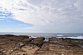 Rock platform off Norah Head
 Looking back at the lighthouse from the rock platform
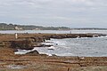 Fishing off Norah Head is a popular activity
 Norah Head rockpool at high tide


References
- "Norah Head Lightstation Group (listing RNE1489)". Australia Heritage Places Inventory. Department of Sustainability, Environment, Water, Population and Communities.
- Norah Head - Central Coast. Retrieved 25 April 2011
- Rowlett, Russ. "Lighthouses of Australia: Northern New South Wales". The Lighthouse Directory. University of North Carolina at Chapel Hill. Retrieved 21 July 2008.
- Australia’s iconic lighthouses[permanent dead link], Australian Geographic, 26 July 2010
- "Norah Head Lightstation Precinct". New South Wales State Heritage Register. Office of Environment & Heritage. H01753. Retrieved 18 May 2018.
- "Norah Head Lighthouse - buildings - Landforms". norahheadlighthouse.com.au. Archived from the original on 8 June 2010. Retrieved 3 September 2010.
- "Norah Head AWS". Climate statistics for Australian locations. Bureau of Meteorology. June 2022. Retrieved 3 June 2022.
Другой контент может иметь иную лицензию. Перед использованием материалов сайта WikiSort.org внимательно изучите правила лицензирования конкретных элементов наполнения сайта.
WikiSort.org - проект по пересортировке и дополнению контента Википедии