geo.wikisort.org - CoastNahant Beach Reservation is a protected coastal reservation covering 67 acres (27 ha) of beach and recreational areas in the town of Nahant, Massachusetts. Nahant Road, formerly known as Nahant Beach Boulevard when it was added to the National Register of Historic Places in 2003, offers access to 7,000-foot-long (2,100 m) Long Beach on the Atlantic Ocean side to the east. The reservation includes a boat ramp with access to Lynn Harbor and shares athletic fields with Lynn Shore Reservation in the area around Nahant Rotary, a traffic circle at the reservation's northern end.[3][4] The reservation is part of the Metropolitan Park System of Greater Boston.
| Nahant Beach Reservation |
|---|
 Long Beach |
Location in Massachusetts Show map of MassachusettsNahant Beach Reservation (the United States) Show map of the United States |
| Location | Nahant, Essex, Massachusetts, United States |
|---|
| Coordinates | 42°26′50″N 70°56′12″W[1] |
|---|
| Area | 67 acres (27 ha)[2] |
|---|
| Elevation | 0 ft (0 m)[1] |
|---|
| Established | ca. 1900 |
|---|
| Operator | Massachusetts Department of Conservation and Recreation |
|---|
| Website | Lynn Shore & Nahant Beach Reservation |
|---|
History
In the early 1900s, privately owned shoreline property at Nahant Beach and Lynn Shore was acquired by the Metropolitan District Commission to create two abutting reservations. Following the purchases, buildings including the Hotel Nahant were removed to give the public access to beaches and to protect natural features.[3] A bathhouse was built at the north end of the reservation in 1901; beach shelters, benches, and a bridle path were added in the early 20th century.[5]
Gallery
References
External links
Metropolitan Park System of Greater Boston |
|---|
| Coastal reservations | |
|---|
| River reservations |
- Alewife Brook
- Charles River
- Chestnut Hill
- Cutler
- Elm Bank
- Hemlock Gorge
- Mystic River
- Neponset River
- Pope John Paul II
- Squantum Point Park
- Upper Charles River
|
|---|
| Woodland reservations |
- Beaver Brook
- Blue Hills
- Breakheart
- Hammond Pond
- Middlesex Fells
- Quincy Quarries
- Southwest Corridor
- Stony Brook
- Wilson Mountain
|
|---|
| Heritage state parks | |
|---|
| Parkways and roads |
- Alewife Brook
- Arborway
- Blue Hills
- Blue Hills Reservation
- Charles River Reservation
- Day Boulevard
- Fellsway
- Fellsway East
- Fellsway West
- Fenway
- Fresh Pond
- Furnace Brook
- Hamond Pond
- Hull Shore Drive
- Jamaicaway
- Lynn Fells
- Lynnway
- Memorial Drive
- Morrissey Boulevard
- Mystic Valley
- Nahant Beach Boulevard
- Nantasket Avenue
- Park Drive
- Quincy Shore Drive
- Revere Beach
- Riverway
- Soldiers Field Road
- Stony Brook
- Storrow Drive
- Truman
- VFW
- West Roxbury
- Winthrop
- Winthrop Shore Drive
|
|---|
- Department of Conservation and Recreation
- Greater Boston
- List of Massachusetts State Parks
|
Текст в блоке "Читать" взят с сайта "Википедия" и доступен по лицензии Creative Commons Attribution-ShareAlike; в отдельных случаях могут действовать дополнительные условия.
Другой контент может иметь иную лицензию. Перед использованием материалов сайта WikiSort.org внимательно изучите правила лицензирования конкретных элементов наполнения сайта.
2019-2026
WikiSort.org - проект по пересортировке и дополнению контента Википедии


 windsurfer
 surfer
 shorebirds, with Little Nahant in the distance
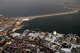 aerial view


