geo.wikisort.org - Coast
Mocha Island (Spanish: Isla Mocha [ˈisla ˈmotʃa]) is a small Chilean island located west of the coast of Arauco Province in the Pacific Ocean. The island is approximately 48 km2 (19 sq mi) in area, with a small chain of mountains running roughly in north-south direction. In Mapuche mythology, the souls of dead people travel west to visit this island. The island today is home to the Mocha Island National Reserve, a nature reserve that covers approximately 45% of the island's surface. The island is noted as the location of numerous historic shipwrecks. The waters off the island are a popular place for recreational sea fishing.
Native name: Isla Mocha | |
|---|---|
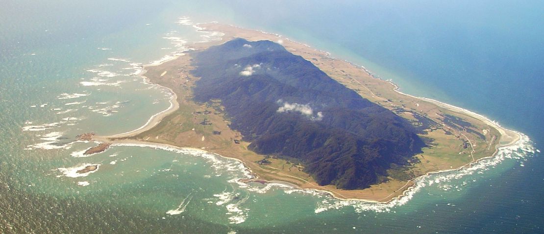 Aerial view of Mocha Island | |
 Mocha Island | |
| Geography | |
| Location | South-central Chile |
| Coordinates | 38°21′54″S 73°54′54″W |
| Area | 48 km2 (19 sq mi) |
| Highest elevation | 300 m (1000 ft) |
| Administration | |
Chile | |
| Region | Bío Bío |
| Province | Arauco |
| Comuna | Lebu |
| Demographics | |
| Population | ~800 |
| Ethnic groups | Chileans, Mapuches |
The Pacific degu (Octodon pacificus), also known as the Mocha Island degu, a species of rodent in the family Octodontidae, is endemic to Mocha Island.
Geology
Geologically, the island is made of sedimentary rock stratum of Ranquil Formation, a formation whose main outcrops lie in the continent.[1] The island was permanently uplifted as result of the 2010 Chile earthquake but this uplift was less than in the adjacent coast where Tirúa had the largest uplift of all the coast.[2] The existence of a splay fault called Tirúa-Mocha Fault may explain the different behaviour of Mocha Island relative to the mainland during this earthquake.[2]
History
The island was historically inhabited by an indigenous coastal population of Mapuches known as the Lafkenches. The first European to document Mocha was Juan Bautista Pastene on September 10, 1544, who named it Isla de San Nicolas de Tolentino.
According to Juan Ignacio Molina, the Dutch captain Joris van Spilbergen observed the use of chilihueques (a South American camelid) by native Mapuches of Mocha Island as plough animals in 1614.[3]
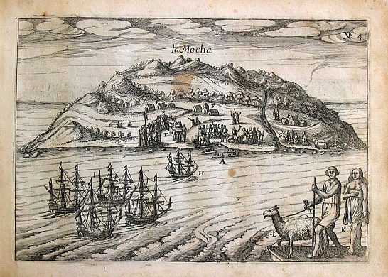
Mocha Island was regularly visited by pirates and privateers from the Netherlands and England. Francis Drake and Olivier van Noort are known to have used the island as a supply base. When Drake was visiting it during his circumnavigation of the globe he was seriously hurt by Mapuches that inhabited the island. Richard Hawkins, Drake's cousin, also passed with his ship the Dainty. Eventually the Mapuche on the island were transported in 1685, from Mocha Island by Governor José de Garro to a reducción on the plain on the right bank of the Bio Bio River called the Valley of Mocha that later became the location of the modern city of Concepción, Chile.
The waters off the island are also noted as the home to a famous 19th century sperm whale, Mocha Dick as depicted by American explorer and author Jeremiah N. Reynolds who published an account, "Mocha Dick: Or The White Whale of the Pacific: A Leaf from a Manuscript Journal" in May, 1839 in The Knickerbocker magazine in New York.[4] Mocha Dick was, in part, the inspiration for the fictional whale Moby Dick in the 1851 novel Moby-Dick by Herman Melville.[5]
Polynesian contact
In December 2007 several human skulls with Polynesian features, such as a pentagonal shape when viewed from behind, were found lying on a shelf in a museum in Concepción. These skulls originated from Mocha Island.[6]
References
- García A., Floreal (1968). Ceccioni, Giovanni (ed.). El Terciario de Chile Zona Central (in Spanish). Santiago de Chile: Ediorial Andrés Bello. pp. 25–57.
- Quezada, Jorge; Jaque, Edilia; Catalán, Nicole; Belmonte, Arturo; Fernández, Alfonso; Isla, Federico (2020). "Unexpected coseismic surface uplift at Tirúa-Mocha Island area of south Chile before and during the Mw 8.8 Maule 2010 earthquake: a possible upper plate splay fault". Andean Geology. National Geology and Mining Service. 47 (2): 295. doi:10.5027/andgeoV47n2-3057.
- The Geographical, Natural and Civil History of Chili, Pages 15 and 16, Volume II
- J. N. Reynolds. "Mocha Dick: or the White Whale of the Pacific: A Leaf from a Manuscript Journal," The Knickerbocker, or New-York Monthly Magazine. Vol. 13, No. 5, May 1839, pp. 377–392.
- Delbanco, Andrew. Melville, His World and Work. New York: Alfred A. Knopf, 2005: 167–168. ISBN 0-375-40314-0
- Lawler, Andrew (June 11, 2010). "Beyond Kon-Tiki: Did Polynesians Sail to South America?". Science. 328 (5984): 1344–1347. Bibcode:2010Sci...328.1344L. doi:10.1126/science.328.5984.1344. PMID 20538927.
Sources
- Francisco Solano Asta-Buruaga y Cienfuegos, Diccionario geográfico de la República de Chile, SEGUNDA EDICIÓN CORREGIDA Y AUMENTADA, NUEVA YORK, D. APPLETON Y COMPAÑÍA. 1899. pg. 449–450 Mocha (Isla de)
External links
 Media related to Isla Mocha at Wikimedia Commons
 Mocha Island travel guide from Wikivoyage
Piracy | |||||||||
|---|---|---|---|---|---|---|---|---|---|
| Periods |
| ||||||||
| Types of pirate |
| ||||||||
| Areas |
| ||||||||
| Major figures |
| ||||||||
| Pirate ships |
| ||||||||
| Pirate battles and incidents | 
| ||||||||
| Piracy law |
| ||||||||
| Slave trade |
| ||||||||
| Pirates in popular culture |
| ||||||||
| Miscellaneous |
| ||||||||
| Meta |
| ||||||||
| |||||||||
Authority control | |
|---|---|
| General |
|
| National libraries | |
На других языках
[de] Mocha (Insel)
Die Insel Mocha (spanisch Isla Mocha) liegt vor der chilenischen Küste und gehört zur Gemeinde (Comuna) Lebu der Región del Bío-Bío in Südchile.- [en] Mocha Island
[es] Isla Mocha
La Isla Mocha es una isla situada frente a las costas de la provincia de Arauco en la Región del Biobío, Chile, a 34,3 kilómetros de Tirúa, aunque administrativamente depende de la comuna de Lebu y cuenta con 800 habitantes.[fr] Île Mocha
L'île Mocha est une petite île côtière du Chili. Les eaux aux alentours sont réputées pour la pêche sportive.[it] Isola Mocha
Mocha (in spagnolo: Isla Mocha) è una piccola isola cilena situata ad ovest della costa della provincia di Arauco, nell'Oceano Pacifico. L'isola ha una superficie di circa 48 km² (19 sq mi), con una piccola catena montuosa che l'attraversa da nord a sud. Nella mitologia mapuche le anime dei morti si dirigono verso ovest per visitare quest'isola.[ru] Моча (остров)
Моча (исп. Mocha) — остров в составе чилийской провинции Арауко. Расположен невдалеке от побережья страны в Тихом океане. Площадь острова составляет 48 км². С севера на юг остров пересекает горная цепь.Другой контент может иметь иную лицензию. Перед использованием материалов сайта WikiSort.org внимательно изучите правила лицензирования конкретных элементов наполнения сайта.
WikiSort.org - проект по пересортировке и дополнению контента Википедии