geo.wikisort.org - Coast
Leptokarya (Greek: Λεπτοκαρυά, Leptokaryá) is a town in Pieria regional unit, Central Macedonia, Greece, former seat of East Olympos municipality, which is part of the municipality of Dio-Olympos. The distance from Katerini is 26 km and the population of the village was 4,225 inhabitants as of 2011.[1]

Leptokarya
Λεπτοκαρυά | |
|---|---|
 Beach of Leptokarya | |
 Leptokarya Location within the regional unit 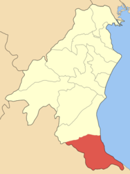 | |
| Coordinates: 40°04′N 22°34′E | |
| Country | Greece |
| Administrative region | Central Macedonia |
| Regional unit | Pieria |
| Highest elevation | 40 m (130 ft) |
| Lowest elevation | 2 m (7 ft) |
| Population (2011)[1] | |
| • Municipal unit | 3,700 |
| Time zone | UTC+2 (EET) |
| • Summer (DST) | UTC+3 (EEST) |
| Postal code | 600 63 |
| Area code(s) | 23520 |
| Vehicle registration | KN |
Location
Lies on the coast of Aegean Sea, under the Mount Olympos. It is located near ancient Leivithra, allegedly the home of Orpheus, major figure in the Greek Mythology. Since the major events and customs in the town is the revival of division of Orpheus.
Tourism
Leptokarya is a popular tourist destination during the summer months due to its beaches, as well as due to its proximity to Mount Olympus.
Transport
The town is served by Leptokarya train station, with local stopping services to Thessaloniki, Kalambaka and Palaiofarsalos and Since 2008, by Proastiakos Thessaloniki to Larissa and Thessaloniki.
See also
- List of settlements in the Pieria regional unit
- Dio-Olympos
- Platamon
References
- "Απογραφή Πληθυσμού - Κατοικιών 2011. ΜΟΝΙΜΟΣ Πληθυσμός" (in Greek). Hellenic Statistical Authority.
Notes
- "Καζταρίδη Ι. Φ., Η Πιερία των περιηγητών και των γεωγράφων'"
This Central Macedonia location article is a stub. You can help Wikipedia by expanding it. |
На других языках
[de] Leptokarya (Pieria)
Leptokarya (griechisch Λεπτοκαρυά (f. sg.)) ist eine Kleinstadt mit 3700 Einwohnern (2011) am Thermaischen Golf. Verwaltungstechnisch bildet sie den gleichnamigen Stadtbezirk der Gemeinde Dion-Olymbos in der griechischen Region Zentralmakedonien. Sie war bis 2010 Verwaltungssitz der ehemaligen Gemeinde Anatolikos Olymbos bis zu deren Eingemeindung nach Dion-Olymbos.- [en] Leptokarya
[ru] Лептокарья
Лептокарья́[3] (греч. Λεπτοκαρυά[2]) — приморский малый город в Греции. Расположен на берегу залива Термаикоса у восточного подножия Олимпа на высоте 30 метров над уровнем моря[1], в 24 километрах к югу от Катерини, в 72 километрах к юго-западу от Салоник и в 252 километрах к северу от Афин. Входит в общину (дим) Дион-Олимбос в периферийной единице Пиерии в периферии Центральной Македонии[2]. Население 3700 жителей по переписи 2011 года[2]. Площадь 66,386 квадратного километра[1].Другой контент может иметь иную лицензию. Перед использованием материалов сайта WikiSort.org внимательно изучите правила лицензирования конкретных элементов наполнения сайта.
WikiSort.org - проект по пересортировке и дополнению контента Википедии