geo.wikisort.org - Coast
Kathiawar ([kɑʈʰijɑʋɑɽ]) is a peninsula, near the far north of India's west coast, of about 61,000 km2 (23,500 sq mi) bordering the Arabian Sea. It is bounded by the Gulf of Kutch in the northwest and by the Gulf of Khambhat (Gulf of Cambay) in the east. In the northeast, it is connected to the rest of Gujarat and borders on the low, fertile hinterland of Ahmedabad. It is crossed by two belts of hill country and is drained radially by nine rivers which have little natural flow aside from in monsoon months, thus dams have been built on some of these. Kathiawar ports have been flourishing centres of trade and commerce since at least the 16th century.[1]
This article needs additional citations for verification. (March 2014) |
Kathiyawar
Saurashtra | |
|---|---|
Peninsula | |
 Kathiawar peninsula as seen from the NASA Earth Observatory | |
 Location of Saurashtra in India | |
| Coordinates: 22°N 71°E | |
| Country | India |
| State | Gujarat |
| Languages | |
| • official | Gujarati |
| Time zone | UTC+5:30 (IST) |
Etymology and history
Kathiawad means the land of the Kathis, a Kshatriya caste who migrated to the region in the 8th century and controlled the southwestern peninsula of contemporary Gujarat.[2]
History

Kathis were spread out in the entire region and dominated central Saurashtra for some centuries. Although the Kathis are believed to have migrated to the area as late as the 16th century, they have played an important part in the documented history of the region. During the reign of Pratihar ruler Mihir Bhoj, the Rajput empire stretched from Kathiawad to the Bay of Bengal.[3] A Haddola inscription confirms that Pratihars continued to rule in this region during the reign of Mahipala I.[4] The peninsula is dotted with antiquities and has a continuous history from prehistoric times to the early periods of the Mahabharata through the Indus civilization.[citation needed] Kathi people particularly influenced the peninsula between the 16th century to the mid-20th century.[citation needed]
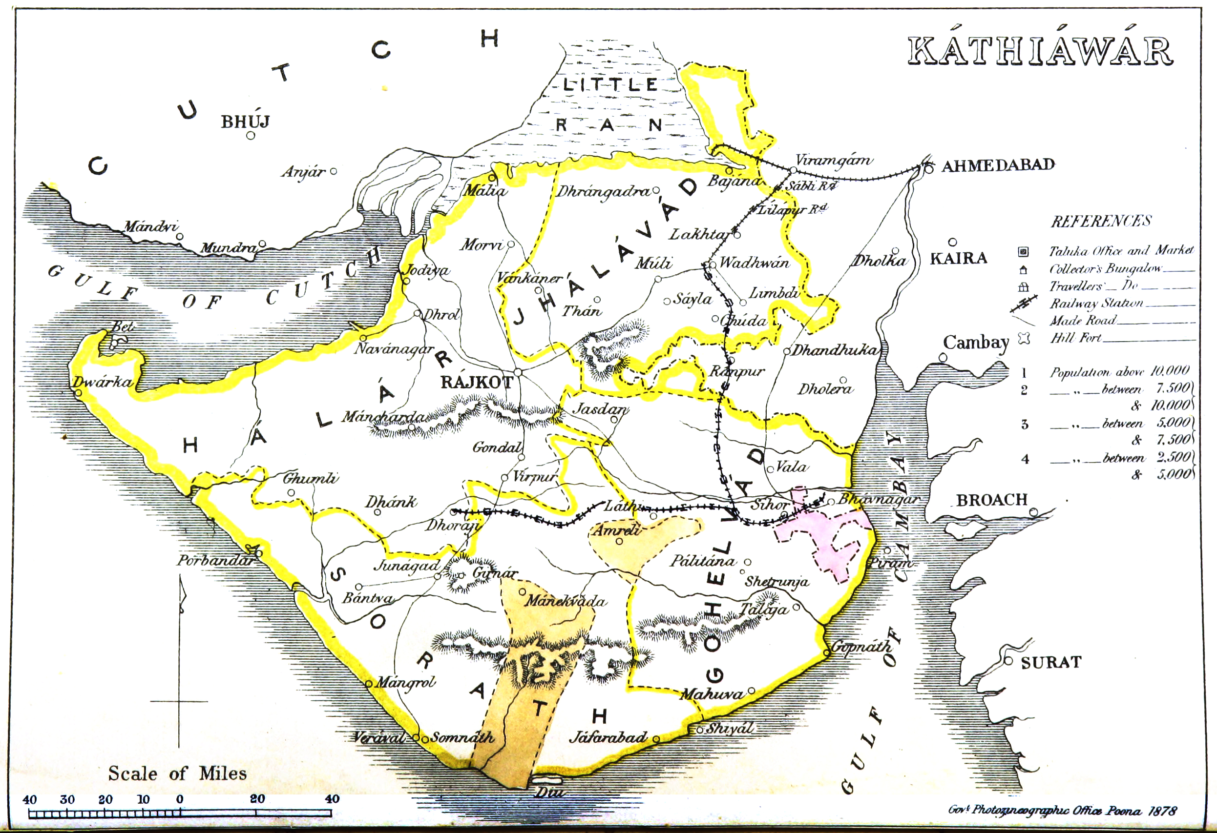
In a geopolitical context, the area of Kathiawar forms the core of Saurashtra. In feudal times, there were certain principal divisions in Saurashtra that fell under princely states: Rajkot State, Jamnagar State, Gondal State, Bhavnagar State, Dhrangadhra State, Morbi State, Jasdan State, Jetpur State, and Wankaner State, Wadhwan State, Limdi state .However, the main area of Kathiawar now covers 10 districts: Rajkot, Bhavnagar, Jamnagar, Surendranagar, Porbandar, Amreli, Junagadh, Botad, Morbi, Gir-Somnath.
For a long time, the name Sorath remained limited to the region when the Chudasama Rajput (Raa' dynasty) ruled from 875 to 1473. At the same time, major Rajput clans that held a sway over this region included the Walas (Kathis), Jethwas, Raijadas, Chudasamas, Gohils, Jhalas, Jadejas, Chavdas, Parmars, Patgirs or Pargirss, Sarvaiyas, Solankis, Khumans and Khachars, Makwanas, Padayas, and Zalas. Most of the princely states of Kathiawar were brought under the British protectorate by 1820, but the first treaty with the British was made from Kathiawar between Vira Wala (Kathi Ruler) of Jetpur and Colonel Walker at Baroda on 26 October 1803. [citation needed]
Literary comment

The state of the region in the early nineteenth century is illustrated in Letitia Elizabeth Landon's poem, "Scene in Kattiawar".
Political history

This section does not cite any sources. (September 2020) |
Before Indian independence in 1947, most of Kathiawar was divided into numerous princely states that were ruled by local potentates who acknowledged British suzerainty in return for local sovereignty. These states comprised the Kathiawar Agency. The rest of the peninsula, primarily in the east along the Gulf of Cambay, were districts ruled directly by the British as part of British India's Bombay Presidency, which included part of the peninsula.
After Indian independence, the states of Kathiawar acceded to India under the Instrument of Accession. In 1947, Junagadh's Muslim ruler acceded his territory to Pakistan. The predominantly Hindu population rebelled, and while the prince fled to Pakistan, a referendum was conducted that merged the kingdom into the Indian Union. The former princely states of Kathiawar were grouped into the new province of Saurashtra, which became the state of Saurashtra in 1950. In 1956, Saurashtra was merged into Bombay State, and in 1960, Bombay state was divided along linguistic lines into the new states of Gujarat (including Kathiawar) and Maharashtra. Diu was under Portuguese rule until it was occupied by Indian troops by 1961. It integrated into India as part of the union territory of Goa, Daman and Diu in 1962.
Major cities
This section does not cite any sources. (September 2020) |
The major cities of Kathiawar are Rajkot in the center of the peninsula, Jamnagar on the Gulf of Kutch, Bhavnagar on the Gulf of Khambhat, Surendranagar and the historic city Wadhwan in the central portion of Gujarat, Porbandar on the west coast, and the historic city of Junagadh in the South. Diu, an island town formerly part of Portuguese India and now part of the Indian union territory of Dadra and Nagar Haveli and Daman and Diu, lies off the south coast of Kathiawar. The city of Somnath and its temple are also located on the south coast.
Districts in Kathiawad Region
- Amreli
- Botad
- Bhavnagar
- Devbhoomi Dwarka
- Gir Somnath
- Jamnagar
- Junagadh
- Morbi
- Porbandar
- Rajkot
- Surendranagar
Geography and ecosystem


The natural vegetation on most of the peninsula is xeric scrub. A range of low hills known as the Gir Hills occupies the south-central portion of the peninsula. The highest of these is Girnar. The hills are home to an enclave of tropical dry broadleaf forest.[5]
Gir National Park and its surroundings host the last remaining Asiatic lion population.[6][7] Other national parks in Kathiawar are Blackbuck National Park, Velavadar on the Gulf of Cambay, and Marine National Park, Gulf of Kutch, near Jamnagar.[citation needed]
Antiquity (places: history, archaeology, nature, religion)


- Dwarika
- Somnath
- Sasan Gir and interiors / Kathi territories in Amreli-Bhavnagar districts
- Vallabhi
- Porbandar
- Junagadh
- Shatrunjay Hills, Palitana
- Sihor
- Palitana
- Virpur (Rajkot) and Gondal
- Jamnagar & Marine National Park
- Velavadar
- Old cities of Gondal, Wadhvan, Morbi, Wankaner
- Diu, India
Notable characters and figures
This article's list of people may not follow Wikipedia's verifiability policy. (October 2013) |
Religion, pre-history, spirituality
- Sudama – Krishna's friend and a character from Mahabharata
- Baba Balak Nath – One of the legendary Naths and Chaurasi Siddhas
- Neminath – One of the Siddhas and 22nd Jain Tirthankar
- Narsinh Mehta (1414-1481) – Poet and saint
- Swaminarayan – Believed to be the manifestation of Purushottam/Parabrahma.[8] Also known as Sahajanand Swami
- Pramukh Swami Maharaj – Guru and Pramukh, or president, of the BAPS Swaminarayan Sanstha, an international Hindu socio-spiritual organization.
- Dayanand Saraswati – Hindu religious scholar, reformer, and founder of the Arya Samaj
- Jalaram Bapa – A mystic and saint
- Shrimad Rajchandra – A prominent Jain philosopher
- Morari Bapu – Preacher, teacher, thinker
- Ramesh Bhai Ojha (Hindi: रमेश भाई ओझा) – Hindu spiritual leader and preacher of Vedanta Philosophy
- Gangasati – Paanbai & Kahadsinhji Gohil mystic saints near samadhiyala
- Kanji Swami – Jain scholar & Saint of Songadh, Also known as "Koh-i-Noor of Kathiawar"
Society, ideology, politics, leadership
- Mohandas Karamchand Gandhi – pre-eminent political and ideological leader of India, and Father of Nation
- Muhammad Ali Jinnah – lawyer, politician, statesman and the founder of Pakistan and Pakistani Father of the Nation
- U. N. Dhebar – Freedom fighter (Indian independence), and President of the Indian National Congress
- Virchand Gandhi – First Gujarati Patriot from Mahuva to visit USA officially and participate in first World Religion Parliament, 1893
- Fatima Jinnah – Mother of Pakistani Nation
Governance, nobility, reforms, politics
- Nawab Sir Muhammad Mahabat Khan III – Babi of Junagadh state
- Maharaja Sir Takhtsinhji Gohil of Bhavnagar – Reformist and progressive ruler who constructed the Bhavnagar State Railway
- Maharaja Bhagvatsinhji of Gondal – A progressive and enlightened ruler, wrote Bhagavadgomandal
- Maharaja Digvijaysinhji Ranjitsinhji Jadeja of Jamnagar - India's first delegate at the League of Nations in 1920, then a UN represtative, Head of Korean War rehabilitation. Sheltered 500 Polish children in his state during WWII; The Good Maharaja
- Maharaja Krishnakumar Sinjhji Gohil – Reformist, progressive and noble Maharaja of Bhavnagar
- Balwantrai Mehta – Freedom fighter, social worker and pioneer of concept of Panchayati Raj
- Jivraj Mehta – Politician, first Chief Minister of Gujarat, aa Surgeon.
Art, literature, poetry, journalism, socialism
- Jhaverchand Meghani – Litterateur, social reformer and freedom fighter
- Kalaguru Ravishankar Raval – a painter, art teacher, art critic, journalist and essayist
- Dalpatram – Poet of Gujarati literature
- Nanalal Dalpatram Kavi – Author and poet
- Sursinhji Takthasinhji Gohil – Known for poetry and Gujarati literature
- Dula Bhaya Kag – Poet, social reformer and freedom fighter
- Amrut Ghayal – Shayar of Gujarati Ghazal
- Kavi Kant – Poet
- Harilal Upadhyay[9] – Author in the Gujarati language
- Chunilal Madia – Author, playwright, poet, journalist, editor
- Ghulam Mohammed Sheikh – Painter, writer, art critic
- Rajendra Shukla – Poet
- Ramesh Parekh – Poet
- Ruswa Majhalumi- Imamuddin Murtaza Khan Babi, a Gujarati language poet and a royal of Pajod state.
Sports, adventure
- K. S. Ranjitsinhji – Maharaja of Nawanagar, cricketer
- Kumar Shri Duleepsinhji – Cricketer
- Vinoo Mankad – Cricketer
- Ashok Mankad – Cricketer
- Dilip Doshi – Cricketer
- Karsan Ghavri – Cricketer
- Ashok Patel – Cricketer
- Dhiraj Parsana – Cricketer
- Ajay Jadeja – Cricketer
- Parthiv Patel – Cricketer
- Ravindra Jadeja – Cricketer
- Siddharth Trivedi – Cricketer
- Cheteshwar Pujara – Cricketer
- Jaydev Unadkat – Cricketer
Cinema, entertainment, music, folklore
- Mohammed Chhel – A magician and a Fakir (mystic)
- Vijay Bhatt – Producer, director and screenwriter
- Nanabhai Bhatt – Indian film director and producer; father of Mahesh Bhatt and Mukesh Bhatt
- Dina Pathak – Actor, director of Gujarati theatre, activist
- Asha Parekh – Actress, director, and producer
- Shahabuddin Rathod – Humorist, writer, teacher
- Parveen Babi – Bollywood actress
- Dimple Kapadia – Bollywood actress
- Manhar Udhas – One of the top Ghazalkars
- Pankaj Udhas – Indian singer, Ghazal singer
- Mehul Kumar – Director, producer
- K. Lal – Indian magician
- Alka Yagnik – Singer
- Ben Kingsley – Actor (ancestral roots in Saurashtra)
- Hemant Chauhan – Singer, Bhajanik
- Neeraj Vora – Film director, dialogue writer, actor
- Himesh Reshammiya – Music composer, singer, artist
- Dilip Joshi – Cinema and television actor
- Anjum Rajabali – Screenwriter, actor, producer
- Chhel Vayeda – Art director and production designer
- Pan Nalin – Film director, screenwriter and documentary maker
- Sanjay Chhel – Film director, writer and lyricist
Business, industry, innovation, entrepreneurship, philanthropy
- Nanji Kalidas Mehta – Industrialist and philanthropist
- Muljibhai Madhvani – Businessman, entrepreneur, industrialist and philanthropist
- Nautamlal Bhagavanji Mehta – Freedom fighter, businessman
- Dhirubhai Ambani – Indian business magnate and entrepreneur who founded Reliance Industries
- Abdul Gaffar Billoo – Pakistani pediatric endocrinologist and philanthropist
- Ahmed Dawood – Industrialist and philanthropist
- Sam Pitroda – Inventor, entrepreneur and policymaker
- Tulsi Tanti – Chairman and managing director of Suzlon Energy
- Abdul Sattar Edhi – Founded Edhi Foundation helping poor and needy
History and culture
- Prince Vijaya – Exiled prince of Sihor colonising Sri Lanka
- Ra Navghan – Historical character during Solanki period
- Devayat Bodar - Historical warrior and savior of Ra Navghan
- Kadu Makrani – Insurgent of the Indian rebellion of 1857
- Mohkam Singh – one of the punj pyare of Sikh religion, was born in Dwarka
See also
- Koli piracy in India
- Saurashtra Kingdom
- Maurya Empire
- Saurashtra language
- Bhagavadgomandal
- State Bank of Saurashtra
- Memons (Kathiawar)
- Ranji Trophy
- Kathiawari Horse Breed
- Gir Cattle or Gir Gaay
References
- Trivedi, A. B. (1943). Kathiawar economics (PDF). Bombay: AB Trivedi, Khalra College.
- Chandrani, Yogesh. "Legacies of Colonial History: Region, Religion, and Violence in Postcolonial Gujarat" (PDF) (1): 2.
{{cite journal}}: Cite journal requires|journal=(help) - Baij Nath Puri (1986). The history of the Pratihāras. Munshiram Manoharlal Publishers. p. xvii.
- Narendra Singh (2001). Encyclopaedia of Jainism. Anmol Publications PVT. LTD.
- "Khathiar-Gir dry deciduous forests". Terrestrial Ecoregions. World Wildlife Fund. Accessed 16 September 2020.
- Singh, H. S.; Gibson, L. (2011). "A conservation success story in the otherwise dire megafauna extinction crisis: The Asiatic lion (Panthera leo persica) of Gir forest" (PDF). Biological Conservation. 144 (5): 1753–1757. doi:10.1016/j.biocon.2011.02.009.
- Singh, H. S. (2017). "Dispersion of the Asiatic lion Panthera leo persica and its survival in human-dominated landscape outside the Gir forest, Gujarat, India". Current Science. 112 (5): 933–940. doi:10.18520/cs/v112/i05/933-940.
- Williams on South Asian Religions and Immigration: Collected Works. Routledge. 2017. ISBN 9781351143103.
- "A Few Words about Shri Harilal Upadhyay"
- This article incorporates text from a publication now in the public domain: Chisholm, Hugh, ed. (1911). "Kathiawar". Encyclopædia Britannica (11th ed.). Cambridge University Press.
External links
Capital: Gandhinagar | ||
| Topics |
|  |
| Regions of Gujarat |
| |
| Districts |
| |
| Major cities | ||
| Ecoregions |
| |
| Economy |
| |
| ||
На других языках
[de] Kathiawar
Kathiawar oder Kathiawad (Gujarati: કાઠીયાવાડ) ist eine ca. 65.000 km² große Halbinsel im Nordwesten Indiens. Sie gehört zum Bundesstaat Gujarat.- [en] Kathiawar
[es] Península de Kathiawar
La península de Kathiawar (en hindi, काठियावाड़) es una península situada en el noroeste de la India, en el estado de Guyarat. Limita: al suroeste, con las aguas del mar Arábigo; al noroeste, con el golfo de Kutch; al sureste con el golfo de Khambhat; y, al norte, con el Rann de Kutch, el gran desierto que estacionalmente se convierte en una gran marisma. La península tiene una superficie de 59.570 km².[ru] Катхиявар
Катхиява́р (гудж. કાઠીયાવાડ, англ. Kathiawar) — полуостров в штате Гуджарат (Индия).Другой контент может иметь иную лицензию. Перед использованием материалов сайта WikiSort.org внимательно изучите правила лицензирования конкретных элементов наполнения сайта.
WikiSort.org - проект по пересортировке и дополнению контента Википедии