geo.wikisort.org - Coast
The Gyda Peninsula (Russian: Гыда́нский полуо́стров, romanized: Gydansky poluostrov) is a geographical feature of the Siberian coast in the Kara Sea. It takes its name from the river Gyda, that flows on the peninsula. It is roughly 400 km long and 360 km wide. This wide peninsula lies between the estuaries of the Ob (Gulf of Ob) and Yenisei Rivers (Yenisei Gulf). The southwestern corner of the peninsula is limited by the Taz Estuary, and across the river lies the Yamal Peninsula. The climate in the whole area is arctic and harsh.
Гыда́нский полуостров (Russian) | |
|---|---|
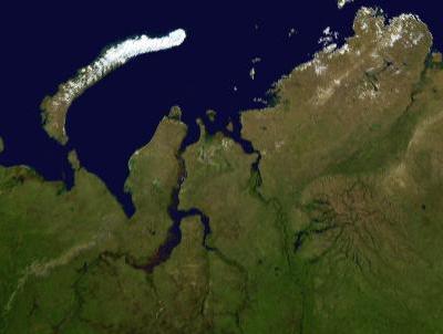
 Location of the Gyda Peninsula. | |
| Geography | |
| Location | Far North |
| Coordinates | 70°N 79°E |
| Adjacent to |
|
| Area | 160,000 km2 (62,000 sq mi) |
| Length | 400 km (250 mi) |
| Width | 360 km (224 mi) |
| Highest elevation | 1,125 m (3691 ft) |
| Administration | |
| Federal subject | Yamal-Nenets autonomous district |
Geography
The Gyda Peninsula is mostly flat, with numerous lakes and rivers. Tanama has its sources in the peninsula.[1] Its ground consists of permafrost and is covered by tundra.
This peninsula has a few arms or subpeninsulas extending northwards into the Kara Sea, where there are some large islands off its shores, including Oleniy, Shokalsky and Vilkitsky Islands. There are two bays in its northern coast, narrow and deep Khalmyer Bay and smaller Yuratski Bay. The peninsula formed between the Khalmyer Bay and neighbouring Yuratski Bay is known as the Mamonta Peninsula (Russian: Полуостров Мамонта; Poluostrov Mamonta, meaning 'Mammoth Peninsula')[2] and the narrow peninsula in the NW formed between this bay and the neighbouring Gulf of Ob is known as the Yavay Peninsula (Russian: полуостров Явай; Poluostrov Yavay).
The Gyda Peninsula is located in the Yamal-Nenets autonomous district administrative region of the Russian Federation.[3] It appears also in the genitive as Gydansky or Gydanskiy Peninsula in many common maps in English.
Archaeological site
A notable archeological find from the peninsula is a mammoth skeleton, now housed in a zoological museum in Saint Petersburg.[4]
Environmental protection
In 1996 the northernmost 8 782 km2 was declared a nature reserve (zapovednik), with a general ban on traffic.[5] The reserve Gyda Nature Reserve was administered from the region capital Tazovsky. 10 December 2019 the protected area was changed into a national park.[6]
Since 2014, massive holes nearly 100 feet wide popped up on the ground of the peninsula, probably due to methane gas blowouts.[7] In 2016, after a hiatus of 25 years (the local research station was closed in 1991), scientists were allowed back on the site to lead geo-cryological studies and monitor the permafrost.[8]
In 2020, officially following the warmest summer recorded in the region since 1881, heavy masses of mud and permafrost started to slide into the sea of the Gydan Bay.[9] The mudslides have also been attributed to the recent launch of the Arctic LNG 2 project, an enormous natural gas extraction site built in the region.[10]
Petroleum
The fossil gas company PAO Novatek has since 2019 had permission for gas extraction from a major part of the peninsula.[11][12] In 2020 the company presented plans for construction of a major port on the Gulf of Ob for gas shipment. The port is called Utrenneye and the project is named Arctic LNG 2.[13][14][15]
See also
- Arctic cooperation and politics
References
- Танама, Great Soviet Encyclopedia in 30 vols. / Ch. ed. A.M. Prokhorov – 3rd ed. – M, 1969–1978.
- Попов С.В., Троицкий В.А. Топонимика морей советской Арктики. — Л: Географическое общество СССР, 1972. — p. 316
- "Yamalo-Nenets administration information". Archived from the original on 27 September 2007. Retrieved 5 November 2007.
- Mammoth
- "Гыданский государственный природный заповедник" (in Russian).
- "Постановление правительства Российской Федерации от 10.12.2019 №1632" (in Russian).
- "Mysterious holes nearly 100 feet deep appear in Siberia's tundra region". Wionews.com. 5 September 2020. Retrieved 4 January 2020.
- "After 25 year break permafrost studies to resume on Gydan Peninsula". Arctic.ru. 8 August 2016. Retrieved 4 January 2020.
- Atle Staalesen (18 September 2020). "Encounter with climate change: Arctic town mayor witnesses melting tundra slide into the sea". Thebarentobserver.com. Retrieved 4 January 2021.
- "European investment in Russia LNG Project in Arctic". Polarjournal.ch. 22 September 2020. Retrieved 4 January 2021.
- "Novatek adds several trillion cubic meters to its Arctic reserves". BarentsObserver. 8 January 2020.
- "Our assets". Novatek. Retrieved 29 April 2020.
- "Here comes Russia's next grand Arctic seaport". BarentsObserver. 12 June 2019.
- "New Arctic terminal will be built twice bigger than planned". BarentsObserver. 16 April 2020.
- "Arctic LNG 2 is another LNG production-related project of NOVATEK". Novatek. Retrieved 29 April 2020.
| Authority control: National libraries |
|---|
На других языках
[de] Gydan-Halbinsel
Die Gydan-Halbinsel (russisch Гыданский полуостров, Gydanski poluostrow) ist eine Halbinsel im nördlichen Westsibirien im asiatischen Teil Russlands.- [en] Gyda Peninsula
[es] Península de Guida
La península de Guida, o Guidán, (en ruso: Гыда́нский полуостров) es una gran península rusa de la costa siberiana del mar de Kara, en el océano Ártico, muy próxima a la península de Yamal. Lleva su nombre por el homónimo río Guida (o Gyda), un corto río (147 km) que discurre por la parte central de la península y que desagua en la homónima bahía de Guidan.[ru] Гыданский полуостров
Гыда́нский полуо́стров — полуостров на севере Западно-Сибирской равнины, вдаётся в Карское море между Тазовской и Обской губами на западе и Енисейским заливом на востоке. Территория полуострова относится к Тазовскому району Ямало-Ненецкого автономного округа и Таймырскому району Красноярского края[1][2]. Северная оконечность полуострова входит в состав государственного природного заповедника «Гыданский».Другой контент может иметь иную лицензию. Перед использованием материалов сайта WikiSort.org внимательно изучите правила лицензирования конкретных элементов наполнения сайта.
WikiSort.org - проект по пересортировке и дополнению контента Википедии