geo.wikisort.org - Coast
Frisius Point (Bulgarian: нос Фризий, romanized: nos Frisius, IPA: [ˈnɔs ˈfrizij]) is the rocky north entrance point of Malak Sechko Cove and southwest entrance point of Golyam Sechko Cove projecting 450 m westwards from the northwest coast of Guangzhou Peninsula on Nelson Island in the South Shetland Islands, Antarctica. The area was visited by early 19th century sealers.[1] Frisius Point is part of both Antarctic Specially Protected Area Harmony Point (ASPA 133)[2] and the BirdLife International Important Bird Area Harmony Point, Nelson Island.[3]
The feature is named after Gemma Frisius (Jemme Reinderszoon, 1508–1555), a Dutch mathematician, cartographer and instrument maker who was the first to describe how a chronometer could be used to determine longitude in navigation, and to propose the use of triangulation to accurately position places for mapmaking; in association with other names in the area deriving from the early development or use of geodetic instruments and methods.
Location
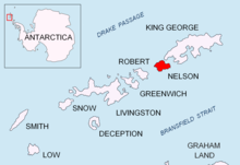
Frisius Point is located at 62°17′27″S 59°13′53″W,[4] which is 1.8 km north-northeast of Harmony Point and 2.45 km southwest of Sabin Point. British mapping of the area in 1968.
Maps
- Livingston Island to King George Island. Scale 1:200000. Admiralty Nautical Chart 1776. Taunton: UK Hydrographic Office, 1968
- South Shetland Islands. Scale 1:200000 topographic map No. 3373. DOS 610 - W 62 58. Tolworth, UK, 1968
- Isla Nelson - Punta Armonía. Shetland del Sur. Escala 1:5000. Servicio Geográfico Militar del Uruguay, 1986
- Antarctic Digital Database (ADD). Scale 1:250000 topographic map of Antarctica. Scientific Committee on Antarctic Research (SCAR). Since 1993, regularly upgraded and updated
Notes
- L. Ivanov. General Geography and History of Livingston Island. In: Bulgarian Antarctic Research: A Synthesis. Eds. C. Pimpirev and N. Chipev. Sofia: St. Kliment Ohridski University Press, 2015. pp. 17–28
- Antarctic Specially Protected Area No 133 (Harmony Point, Nelson Island, South Shetland Islands): Revised Management Plan. Measure 7 (2012) ATCM XXXV - CEP XV. Hobart, 2012
- BirdLife International Important Bird Area Harmony Point, Nelson Island
- Bulgarian Antarctic Gazetteer. Antarctic Place-names Commission
References
- Bulgarian Antarctic Gazetteer. Antarctic Place-names Commission. (details in Bulgarian, basic data in English)
External links
- Frisius Point. Adjusted Copernix satellite image
This article includes information from the Antarctic Place-names Commission of Bulgaria which is used with permission.
This Nelson Island, South Shetlands location article is a stub. You can help Wikipedia by expanding it. |
На других языках
[de] Frisius Point
Der Frisius Point (englisch; bulgarisch нос Фризий .mw-parser-output .Latn{font-family:"Akzidenz Grotesk","Arial","Avant Garde Gothic","Calibri","Futura","Geneva","Gill Sans","Helvetica","Lucida Grande","Lucida Sans Unicode","Lucida Grande","Stone Sans","Tahoma","Trebuchet","Univers","Verdana"}nos Frisij) ist felsige Landspitze an der Nordwestküste der Guangzhou-Halbinsel von Nelson Island im Archipel der Südlichen Shetlandinseln. Sie trennt 1,8 km nordnordöstlich des Harmony Point und 2,45 km südwestlich des Sabin Point die Einfahrt zur Malak Sechko Cove im Süden von derjenigen zur Golyam Sechko Cove im Nordosten.- [en] Frisius Point
Другой контент может иметь иную лицензию. Перед использованием материалов сайта WikiSort.org внимательно изучите правила лицензирования конкретных элементов наполнения сайта.
WikiSort.org - проект по пересортировке и дополнению контента Википедии