geo.wikisort.org - Coast
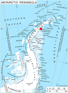
Foyn Point (65°15′S 61°38′W) is a point surmounted by a peak 525 metres (1,720 ft) high, forming the southeast extremity of Blagoevgrad Peninsula and marking the north side of the entrance to Exasperation Inlet, on Oscar II Coast on the east side of Graham Land, Antarctica. Sir Hubert Wilkins on a flight of December 20, 1928 photographed what appeared to be an island off the east coast, later charting it in 66°30′S 62°30′W (present Slav Point). Subsequent comparison of Wilkins' photographs of this feature with those taken by the Falkland Islands Dependencies Survey, who charted the coast in 1947, indicate that this point, although considerably north of the position reported by Wilkins, is the feature named by him as "Foyn Island". The name Foyn Point is given to the southeast extremity of this feature. It is named for Svend Foyn.[1]
Further reading
- Defense Mapping Agency 1992, Sailing Directions (planning Guide) and (enroute) for Antarctica, P 276
- Grace A. Nield, Valentina R. Barletta, Andrea Bordoni, Matt A. King, Pippa L. Whitehouse, Peter J. Clarke, Eugene Domack, Ted A. Scambos, Etienne Berthier, Rapid bedrock uplift in the Antarctic Peninsula explained by viscoelastic response to recent ice unloading
- M. R. Cape, Maria Vernet, Pedro Skvarca, Sebastián Marinsek, Ted Scambos, Eugene Domack, Foehn winds link climate‐driven warming to ice shelf evolution in Antarctica, https://doi.org/10.1002/2015JD023465
External links
- Foyn Point on USGS website
- Foyn Point on AADC website
- Foyn Point on SCAR website
- Foyn Point on marineregions.org
- Foyn Point long term updated weather forecast
References
- "Foyn Point". Geographic Names Information System. United States Geological Survey. Retrieved 2012-04-05.
![]() This article incorporates public domain material from the United States Geological Survey document: "Foyn Point". (content from the Geographic Names Information System)
This article incorporates public domain material from the United States Geological Survey document: "Foyn Point". (content from the Geographic Names Information System)
This Foyn Coast location article is a stub. You can help Wikipedia by expanding it. |
На других языках
[de] Foyn Point
Der Foyn Point ist eine von einem 525 m hohen Berggipfel überragte Landspitze an der Oskar-II.-Küste des Grahamlands auf der Antarktischen Halbinsel. Sie markiert die Nordseite der Einfahrt zum Exasperation Inlet.- [en] Foyn Point
Другой контент может иметь иную лицензию. Перед использованием материалов сайта WikiSort.org внимательно изучите правила лицензирования конкретных элементов наполнения сайта.
WikiSort.org - проект по пересортировке и дополнению контента Википедии