geo.wikisort.org - Coast
Domburg is a resort in the Wanica District of Suriname, located on the northern coast of South America. Its population at the 2012 census was 5,661.[1]
Domburg, Suriname | |
|---|---|
Resort | |
 Former plantation (1885) | |
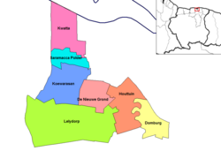 Map showing the resorts of Wanica District. Domburg | |
 Domburg | |
| Coordinates: 5°42′N 55°05′W | |
| Country | |
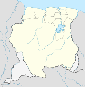
| District | Wanica District |
| Area | |
| • Total | 37 km2 (14 sq mi) |
| Elevation | 5 m (16 ft) |
| Population (2012) | |
| • Total | 5,661 |
| • Density | 150/km2 (400/sq mi) |
| Time zone | UTC-3 (AST) |
Domburg is located on the Suriname River, about 16 kilometers to the south of the capital of Paramaribo. It is bordered by the district Commewijne to the north and east, Para to the south and the resort Houttuin to the west. Near Domburg in Oost, an artificial white sand beach, White Beach, has been created along the Suriname River.[2]
History
Domburg was founded as a sugar plantation in 1737 by P. Thourron,[3] In 1873 the local population started a program of independent agriculture which was encouraged by governor van Sypesteyn who designated Nieuw Amsterdam and Domburg as suitable locations.[4] Later Domburg became the seat of the Commissioner of the former District of Upper Suriname.[5] In the 1930s a road was built connecting Domburg with Paramaribo which attracted industry to the area.[5]
Notable people
- Dési Bouterse (1945), President of Suriname (2010-2020)[6]
- Max Woiski Sr. (1911-1981), musician[7]
References
- Statoids.com
- "White Beach Suriname". Suriname Vakantie Reis (in Dutch). Retrieved 23 May 2020.
- "Plantages / D / Domburg". Suriname Plantages (in Dutch). Retrieved 5 May 2020.
- "Encyclopaedie van Nederlandsch West-Indië - Page 441 - Landbouw" (PDF). Digital Library for Dutch Literature (in Dutch). 1916. Retrieved 5 May 2020.
- "District Wanica Info". Suriname.nu (in Dutch). Retrieved 5 May 2020.
- "BOUTERSE 72 JAAR: "Als je moe bent ga je slapen"". Dagblad Suriname (in Dutch). Retrieved 13 July 2020.
- "Muziekencyclopedie Biografie Max Woiski Sr". Muziek Encyclopedie (in Dutch). Retrieved 13 July 2020.
External links
 Media related to Domburg, Suriname at Wikimedia Commons
| Brokopondo District |  | |
|---|---|---|
| Commewijne District |
| |
| Coronie District | ||
| Marowijne District |
| |
| Nickerie District |
| |
| Para District | ||
| Paramaribo District | ||
| Saramacca District |
| |
| Sipaliwini District | ||
| Wanica District | ||
Authority control | |
|---|---|
| General |
|
| Other |
|
This Suriname location article is a stub. You can help Wikipedia by expanding it. |
На других языках
[de] Domburg (Suriname)
Domburg (Sranantongo: Dumborgu) ist ein Ort und ehemalige Plantage am Suriname (Fluss), im Distrikt Wanica, in der Republik Suriname mit 5661 Einwohnern (Census 2012).- [en] Domburg, Suriname
[ru] Домбург
Домбург (нидерл. Domburg; сранан-тонго Dumborgu) — город и одна из семи коммун округа Ваника в Суринаме. Домбург расположен на левом берегу реки Суринам, примерно в 16 километрах от столицы страны Парамарибо. На севере и востоке он граничит с курортом Домбург в округе Коммевейне. Рядом с городом находится белый пляж. Согласно переписи населения 2012 года в Домбурге проживал 5 661 человек.Другой контент может иметь иную лицензию. Перед использованием материалов сайта WikiSort.org внимательно изучите правила лицензирования конкретных элементов наполнения сайта.
WikiSort.org - проект по пересортировке и дополнению контента Википедии