geo.wikisort.org - Coast
Clifton Beach is a coastal suburb in the Cairns Region, Queensland, Australia.[2] In the 2016 census, Clifton Beach had a population of 3,146 people.[1]
| Clifton Beach Cairns, Queensland | |||||||||||||||
|---|---|---|---|---|---|---|---|---|---|---|---|---|---|---|---|
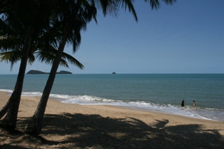 Clifton Beach, 2013 | |||||||||||||||
 Clifton Beach | |||||||||||||||
| Coordinates | 16.7719°S 145.6683°E | ||||||||||||||
| Population | 3,146 (2016 census)[1] | ||||||||||||||
| • Density | 408.6/km2 (1,058/sq mi) | ||||||||||||||
| Postcode(s) | 4879 | ||||||||||||||
| Area | 7.7 km2 (3.0 sq mi) | ||||||||||||||
| Time zone | AEST (UTC+10:00) | ||||||||||||||
| Location |
| ||||||||||||||
| LGA(s) | Cairns Region | ||||||||||||||
| State electorate(s) | Barron River | ||||||||||||||
| Federal division(s) | Leichhardt | ||||||||||||||
| |||||||||||||||
Geography
Clifton Beach is a dormitory suburb of Cairns located on the shores of the Coral Sea. It has a long sandy beach, also called Clifton Beach, along the seafront (16.7671°S 145.6771°E).[3][4][5]
Offshore are Cook Bay (16.771°S 145.681°E) and Trinity Bay (16.759°S 145.687°E).[6][3]
The Captain Cook Highway enters the suburb from the south (Kewarra Beach) and exits to the north (Palm Cove).[3]
History
Clifton Beach is situated in the Djabugay (Tjapukai) traditional Aboriginal country. [7]
Clifton Beach was named as a suburb on 2 May 1959 after Clifton, Perthshire, Scotland, which was the birthplace of Mary Hunter Smart, a settler in the area in the 1880s.[2]
Clifton Beach Post Office opened on 2 June 1969.[8]
In the 2016 census, Clifton Beach had a population of 3,146 people.[1]
Education
There are no schools in Clifton Beach. The nearest government primary school is Trinity Beach State School in Trinity Beach to the south-east. The nearest government secondary school is Smithfield State High School in Smithfield to the south.[3]
Amenities
Clifton Village is a shopping centre at 55 Endeavour Road off the Captain Cook Highway (16.7648°S 145.6691°E).[9][10] It is anchored by a Coles supermarket and contains the Clifton Beach Post Office.[11][12]
There are a number of parks in the suburb, including:
- Eddy Street Park (16.7645°S 145.6707°E)[13]
- Edward Mann Park (16.7696°S 145.6761°E)[13]
References
- Australian Bureau of Statistics (27 June 2017). "Clifton Beach (SSC)". 2016 Census QuickStats. Retrieved 20 October 2018.
- "Clifton Beach – suburb in Cairns Region (entry 48571)". Queensland Place Names. Queensland Government. Retrieved 6 March 2022.
- "Queensland Globe". State of Queensland. Retrieved 11 August 2022.
- "Mountain ranges beaches and sea passages - Queensland". Queensland Open Data. Queensland Government. 12 November 2020. Archived from the original on 25 November 2020. Retrieved 25 November 2020.
- "Clifton Beach – beach in Cairns Regional (entry 39692)". Queensland Place Names. Queensland Government. Retrieved 6 March 2022.
- "Bays - Queensland". Queensland Open Data. Queensland Government. 12 November 2020. Archived from the original on 25 November 2020. Retrieved 25 November 2020.
- "First people cultural history". Cairns Regional Council. Archived from the original on 21 April 2017. Retrieved 23 June 2020.
- Premier Postal History. "Post Office List". Premier Postal Auctions. Archived from the original on 15 May 2014. Retrieved 10 May 2014.
- "Building areas - Queensland". Queensland Open Data. Queensland Government. 17 November 2020. Archived from the original on 17 November 2020. Retrieved 17 November 2020.
- "Clifton Village Shopping Centre". Clifton Village Shopping Centre. Archived from the original on 11 March 2022. Retrieved 10 August 2022.
- "Stores". Clifton Village Shopping Centre. Archived from the original on 11 March 2022. Retrieved 10 August 2022.
- "Clifton Beach Post Office". Australia Post. Archived from the original on 10 August 2022. Retrieved 10 August 2022.
- "Land for public recreation - Queensland". Queensland Open Data. Queensland Government. 20 November 2020. Archived from the original on 22 November 2020. Retrieved 22 November 2020.
External links
![]() Media related to Clifton Beach, Queensland at Wikimedia Commons
Media related to Clifton Beach, Queensland at Wikimedia Commons
- "Clifton Beach". Queensland Places. Centre for the Government of Queensland, University of Queensland.
Другой контент может иметь иную лицензию. Перед использованием материалов сайта WikiSort.org внимательно изучите правила лицензирования конкретных элементов наполнения сайта.
WikiSort.org - проект по пересортировке и дополнению контента Википедии