geo.wikisort.org - Coast
Cancún (Spanish pronunciation: [kaŋˈkũn] ![]() pronunciation (help·info)), often Cancun in English (without the accent; /kænˈkuːn/ or /kɑːn-/)[3] is a city in southeast Mexico on the northeast coast of the Yucatán Peninsula in the Mexican state of Quintana Roo. It is a significant tourist destination in Mexico[4] and the seat of the municipality of Benito Juárez. The city is on the Caribbean Sea and is one of Mexico's easternmost points.
pronunciation (help·info)), often Cancun in English (without the accent; /kænˈkuːn/ or /kɑːn-/)[3] is a city in southeast Mexico on the northeast coast of the Yucatán Peninsula in the Mexican state of Quintana Roo. It is a significant tourist destination in Mexico[4] and the seat of the municipality of Benito Juárez. The city is on the Caribbean Sea and is one of Mexico's easternmost points.
Cancún | |
|---|---|
City | |
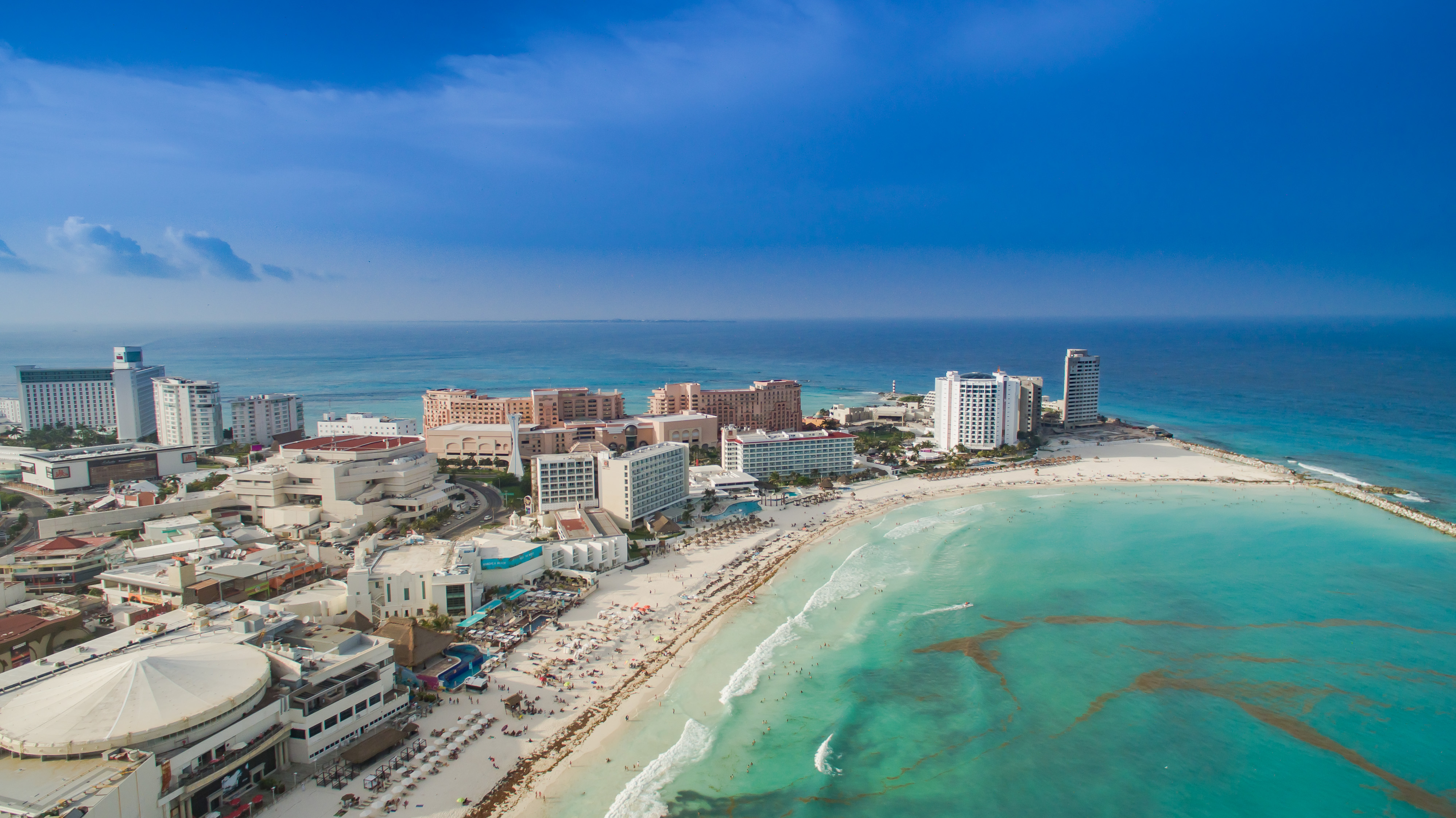
 Above, from left to right: Aerial view of the tourist area, Kukulcán Boulevard, beach, Alacrán Temple in the Yamil Lu'um Archaeological Zone, El Rey Archaeological Site, View of the hotel zone, Caracol Beach and Puerto Juárez. | |
 Flag  Seal | |
 Cancún Location in Mexico Cancún Cancún (Mexico) | |
| Coordinates: 21°09′38″N 86°50′51″W | |
| Country | |
| State | |
| Municipality | |
| Founded | April 20, 1970 |
| Government | |
| • Mayor | Mara Lezama Espinosa (MORENA) |
| Area | |
| • Total | 1,978.75 km2 (764.00 sq mi) |
| Elevation | 10 m (30 ft) |
| Highest elevation | 10 m (30 ft) |
| Lowest elevation | 0 m (0 ft) |
| Population (2020[2]) | |
| • Total | 888,797 |
| • Density | 450/km2 (1,200/sq mi) |
| Demonym | Cancunense |
| Time zone | UTC−5 (EST) |
| Postal code | 77500 |
| Area code | 998 |
| Federal Routes | |
| Website | www |
Cancún is just north of Mexico's Caribbean coast resort area known as the Riviera Maya.
Etymology and coat of arms
According to early Spanish sources, the island of Cancún was originally known to its Maya inhabitants as Nizuc (Yucatec Maya: niʔ suʔuk), meaning either 'promontory' or 'point of grass'.[5]
The name Cancún, Cancum or Cankun first appears on 18th-century maps.[6] In older English-language documents, the city's name is sometimes spelled Cancoon, an attempt to convey the sound of the name.[7]
Cancún is derived from the Mayan name kàan kun, composed of kàan 'snake' and the verb kum ~ kun 'to swell, overfill'.[8] Two translations have been suggested: the first is 'nest of snakes' and the second, less accepted one is 'place of the golden snake'.[9] Snake iconography was prevalent at the pre-Columbian site of Nizuc.[5]
The shield of the municipality of Benito Juárez, which represents the city of Cancún, was designed by the Mexican-American artist Joe Vera.[10] It is divided into three parts: the color blue symbolizes the Caribbean Sea, the yellow the sand and the red the sun with its rays.
History
| Year | Pop. | ±% |
|---|---|---|
| 1990 | 167,730 | — |
| 1995 | 297,183 | +77.2% |
| 2000 | 397,191 | +33.7% |
| 2005 | 526,701 | +32.6% |
| 2010 | 628,306 | +19.3% |
| 2015 | 743,626 | +18.4% |
| 2020 | 888,797 | +19.5% |
| sources:[11] | ||
In the years after the Spanish conquest of Yucatán, much of the Maya population died or left as a result of disease, warfare, and famines, leaving only small settlements on Isla Mujeres and Cozumel Island.[12]
Cancún is a planned city, created to foster tourism. When development of the area as a resort was started on January 23, 1970, Isla Cancún had only three residents, all caretakers of the coconut plantation of Don José de Jesús Lima Gutiérrez, who lived on Isla Mujeres. Some 117 people lived in nearby Puerto Juárez, a fishing village and military base.[13][self-published source?]

Due to the reluctance of investors to gamble on an unknown area, the Mexican federal government financed the first nine hotels.[13]
The city began as a tourism project in 1974 as an Integrally Planned Center, a pioneer of FONATUR (Fondo Nacional de Fomento al Turismo, National Fund for Tourism Development), formerly known as INFRATUR. Since then, it has undergone a comprehensive transformation from being a fisherman's island to being one of the two most well-known Mexican resorts, along with Acapulco.
Most 'Cancunenses' are from Yucatán and other Mexican states. A growing number are from the rest of the Americas and Europe. The municipal authorities have struggled to provide public services for the constant influx of people, as well as limiting squatters and irregular developments, which now[when?] occupy an estimated ten to fifteen percent of the mainland area on the fringes of the city.[13]
Drug trafficking network

In the 21st century, Cancún had largely avoided the bloodshed associated with the trade of illegal drugs, but is known for its retail drug sales to tourists as well as for being a center of money laundering.[14] The links with Cancún date from the 1990s and early 2000s, when the area was controlled by the Juárez and Gulf drug cartels. By 2010 Los Zetas, a group that broke away from the Gulf Cartel, had taken control of many smuggling routes through the Yucatán, according to the U.S. Drug Enforcement Administration.[15]
There have been violent acts in the city related to drug trafficking.[16] Between 2013 and 2016 there were 76 murders: 31 in 2016,[16] and at least 193 in 2017,[17] the vast majority related to drug trafficking.[18] Most have occurred in the urban nucleus, and there have been various violent episodes with firearms in the so-called "Zona Hotelera".[18] Beginning in 2018 with a high wave of violence, Cancún is above the national average in homicides.[19] In January 2018 alone there were 33 homicides, triple the number from January 2017.[20]
The violent acts have begun to put pressure on the tourism industry, where in January 2019, Cancún saw its first decrease in international passengers in seven years.[21]
Geography
City layout


Apart from the island tourist zone (part of the Mesoamerican Barrier Reef System), the Mexican residential section of the city, the downtown part of which is known as "El Centro", follows a master plan that consists of "supermanzanas"[22] (superblocks), giant trapezoids with a central, open, non-residential area cut in by u-shaped residential streets.
Ave. Tulum is the main north-south artery, connecting downtown to the airport, which is some 19 km (12 mi) south of downtown.[23] Tulum is bisected by Ave. Cobá. East of Ave. Tulum, Cobá becomes Ave. Kukulcan which serves as the primary road through the 7-shaped hotel zone. Ave. Tulum ends on the north side at Ave. Paseo José López Portillo which connects to the main highway west to Chichén Itzá and Mérida. Another major north-south road is Ave. Bonampak which runs roughly parallel to Ave. Tulum. The main ferry to Isla Mujeres is located in Puerto Juárez, on Ave. Paseo José López Portillo.
Cancún's mainland or downtown area has diverged from the original plan; development is scattered around the city. The remaining undeveloped beach and lagoon front areas outside the hotel zone are now under varying stages of development, in Punta Sam and Puerto Juarez to the north, continuing along Bonampak and south toward the airport along Boulevard Donaldo Colosio. One development abutting the hotel zone is Puerto Cancún;[24] also Malecon Cancún[25] is another large development.
Climate

Cancún has a tropical climate, specifically a tropical wet and dry climate (Köppen Aw), with little temperature difference between months, but pronounced rainy and dry seasons. The city is hot year-round, and moderated by onshore trade winds, with an annual mean temperature of 27.1 °C (80.8 °F). Unlike inland areas of the Yucatán Peninsula, sea breezes restrict high temperatures from reaching 36 °C (97 °F) on most afternoons. Annual rainfall is around 1,340 millimeters (52.8 in), falling on 115 days per year.
The rainy season runs from May through late October, when hot temperatures, high humidity, and quick, but intense summer thundershowers are common. The dry season normally begins in December and runs through April, when more temperate conditions occur as the northeast trade winds bring northerly breezes, sunshine, and relative humidity is lowest. The hotel zone juts into the Caribbean Sea and is therefore surrounded by ocean keeping daytime temperatures around 1 to 2 °C (1.8 to 3.6 °F) cooler. Windspeeds are higher than at the airport located some distance inland, which is the official meteorological station for Cancún, averages as shown below.[26]
Thanks to the Yucatán current continually bringing warm water from further south, the sea temperature is always very warm, with lows of 79 °F (26 °C) in winter and highs of 84 °F (29 °C) in summer.[27]
| Climate data for Cancún | |||||||||||||
|---|---|---|---|---|---|---|---|---|---|---|---|---|---|
| Month | Jan | Feb | Mar | Apr | May | Jun | Jul | Aug | Sep | Oct | Nov | Dec | Year |
| Record high °C (°F) | 33 (91) |
38 (100) |
39 (102) |
38 (100) |
39 (102) |
39 (102) |
39 (102) |
41.5 (106.7) |
38.5 (101.3) |
38 (100) |
37 (99) |
33.5 (92.3) |
41.5 (106.7) |
| Average high °C (°F) | 28.3 (82.9) |
29.4 (84.9) |
30.7 (87.3) |
32.2 (90.0) |
33.5 (92.3) |
33.7 (92.7) |
34.3 (93.7) |
34.8 (94.6) |
33.7 (92.7) |
31.6 (88.9) |
29.8 (85.6) |
28.6 (83.5) |
31.7 (89.1) |
| Daily mean °C (°F) | 24.1 (75.4) |
24.8 (76.6) |
25.8 (78.4) |
27.4 (81.3) |
28.7 (83.7) |
29.2 (84.6) |
29.5 (85.1) |
29.7 (85.5) |
29 (84) |
27.5 (81.5) |
25.9 (78.6) |
24.5 (76.1) |
27.2 (81.0) |
| Average low °C (°F) | 19.8 (67.6) |
20.3 (68.5) |
21.0 (69.8) |
22.6 (72.7) |
23.9 (75.0) |
24.7 (76.5) |
24.8 (76.6) |
24.6 (76.3) |
24.3 (75.7) |
23.3 (73.9) |
21.9 (71.4) |
20.5 (68.9) |
22.6 (72.7) |
| Record low °C (°F) | 13 (55) |
12 (54) |
9.5 (49.1) |
14 (57) |
18 (64) |
20.5 (68.9) |
21 (70) |
20 (68) |
19 (66) |
15 (59) |
12 (54) |
12 (54) |
9.5 (49.1) |
| Average rainfall mm (inches) | 104.6 (4.12) |
49.5 (1.95) |
44.1 (1.74) |
41.2 (1.62) |
86.9 (3.42) |
138.3 (5.44) |
77.9 (3.07) |
87.5 (3.44) |
181.9 (7.16) |
271.9 (10.70) |
130.3 (5.13) |
86.1 (3.39) |
1,300.2 (51.19) |
| Average rainy days (≥ 0.1 mm) | 9.4 | 5.9 | 5.0 | 4.1 | 6.7 | 11.0 | 9.3 | 9.7 | 14.0 | 16.4 | 11.4 | 9.8 | 112.7 |
| Source: Servicio Meteorológico Nacional (1951–2010)[28] | |||||||||||||
| Jan | Feb | Mar | Apr | May | Jun | Jul | Aug | Sep | Oct | Nov | Dec |
|---|---|---|---|---|---|---|---|---|---|---|---|
| 79 °F
26 °C |
79 °F
26 °C |
79 °F
26 °C |
81 °F
27 °C |
82 °F
28 °C |
84 °F
29 °C |
84 °F
29 °C |
84 °F
29 °C |
84 °F
29 °C |
84 °F
29 °C |
82 °F
28 °C |
81 °F
27 °C |
Tropical storms and hurricanes

The tropical storm season lasts from May to December, the rainy season extends into January with peak precipitation in October. February to early May tend to be drier with only occasional scattered showers. Cancún is located in one of the main Caribbean hurricane impact areas. Although large hurricanes are rare, they have struck near Cancún in recent years, Hurricane Wilma in 2005 being the largest. Hurricane Gilbert made a devastating direct hit on Cancún in September 1988 and the tourist hotels needed to be rebuilt. In both cases, federal, state and municipal authorities were well prepared to deal with most of the effects on tourists and local residents.[30] Hurricane Dean in 2007 also made its mark on the city of Cancún.
1988's Hurricane Gilbert was the second most intense hurricane ever observed in the Atlantic basin. It landed on the Yucatán peninsula after crossing over the island of Cozumel. In the Cancún region, a loss of $87 million (1989 USD) due to a decline in tourism was estimated for the months of October, November and December in 1988.[31]
On October 21, 2005, Hurricane Wilma made landfall on Mexico's Yucatán Peninsula as a powerful Category 4 hurricane, with strong winds in excess of 150 mph (240 km/h). The hurricane's eye first passed over the island of Cozumel, and then made an official landfall near Playa del Carmen in the state of Quintana Roo at around 11 p.m. local time on October 21 with winds near 140 mph (230 km/h). Portions of the island of Cozumel experienced the calm eye of Wilma for several hours with some blue skies and sunshine visible at times. The eye slowly drifted northward, with the center passing just to the west of Cancún, Quintana Roo.
Two years later after Hurricane Wilma, in 2007, Hurricane Dean made landfall as a Category 5 storm in Majahual, 190 miles (310 km) to the south of Cancún. Fierce winds at the edge of Dean's impact cone stripped sand off 7.5 miles (12.1 km) of beaches from Punta Cancún (Camino Real Hotel) to Punta Nizuc (Club Med).[32] The authorities asked tourism operators to suspend sending tourists to Cancún while Hurricane Dean was approaching, but did ask airlines to send empty planes, which were then used to evacuate tourists already there.[33]
Attractions

Old Airport Control Tower Memorial
Despite being a young city, Cancún has a memorial monument of its foundation on a replica of the old Airport Control Tower that resembles to its own date of foundation. The original control tower was a provisional wooden structure, the work of Mexican architects Agustín and Enrique Landa Verdugo.[34]
The old airport was located on the same part of the city that today corresponds to the Kabah Avenue. The tower is 15 meters tall, has a 45 step staircase and has a base dimension of 5 × 5 meters. The memorial was first built in 2002 with a donation by Aerocaribe, a local airline, but the structure was damaged after Hurricane Wilma in 2005. After pleas by the local people to rebuild the tower memorial, a new version was erected in 2010, which was later abandoned without proper maintenance until Woox Pinturas, a local wood maintenance company, made a donation to restore the structure to its original appearance.[35]
El Ceviche Fountain
The real name of this monument is "Caribbean Fantasy," located in the heart of downtown Cancun, between the Coba and Tulum avenues intersection. It is the nerve center of the daily urban traffic of the city. It has witnessed multiple social and political events, undergoing constant repairs and remodeling for years.
Six years after Quintana Roo got recognized as the youngest state in the Mexican Republic and barely a decade after the city of Cancun was born, on October 22 and 23, 1981, the North-South Summit was held at the now defunct Sheraton Hotel. Two abstract pillars made of metal crossbeams gave the structure a stepped pyramidal appearance, with small masts displaying the flags of the countries attending the 1981 North-South Summit. The author, Lorraine Pinto, added details representing Quetzalcoatl on the sides, resembling the pyramid of Chichen-Itza, located in Yucatan.
In 1994, the municipal authorities of Cancun decided to demolish the commemorative structure because the city had been the scene of one of the most devastating climatic-environmental phenomena in the history of the Yucatan Peninsula, Hurricane Gilberto. The sculpture was irreversibly affected, leaving only the solid concrete base and the metal skeleton.
Due to its crosswise and bare appearance, the locals began to call it "Insectronic," a device manufactured by the Steren company to kill flies and mosquitoes. The municipal authorities decided to keep its base and the dynamics of the water fountain.
Once again, Lorraine Pinto was on call to create what locals began to call the Ceviche Fountain or the Ceviche Roundabout.
Maya archeological sites
There are some small Mayan vestiges of the pre-Columbian Maya civilization in Cancún. El Rey (Las Ruinas del Rey) is located in the Hotel Zone. El Meco, a more substantial site, is found on the mainland just outside the city limits on the road north to Punta Sam. [citation needed]
Close by in the Riviera Maya and the Grand Costa Maya, there are sites such as Cobá and Muyil (Riviera) the small Polé (now Xcaret), and Kohunlich, Kinichná, Dzibanché, Oxtankah, Tulum, and Chacchoben, in the south of the state. Chichén Itzá is in the neighboring state of Yucatán.
Sports
Soccer club Atlante F.C. was founded in 1916 in Mexico City and moved to Cancún in 2007 due to poor attendance in Mexico City.[36] In June 2020, a possible move of Atlante F.C. began to be speculated. On June 26, the relocation of that club to back Mexico City became official, effectively losing its site in Cancun.[37] The same day, the relocation of Cafetaleros de Chiapas was announced, the team was moved to Cancún and renamed as Cancún F.C.[38] They play in the Mexican second division Liga de Expansión MX at Estadio Andrés Quintana Roo. The city is also home to the Pioneros de Cancún, who play in the third division Liga Premier de México.
The Cancun Tiburones (sharks), are a professional American football team playing in the FAM, the largest Pro American Football league in Mexico.
The city is also home to the baseball team Tigres de Quintana Roo, who play in the Mexican League (LMB).

Transportation

Cancún is served by the Cancún International Airport with an added main runway that commenced operation as of October 2009. It has many flights to North America, Central America, South America, and Europe. It is located on the northeast of the Yucatán Peninsula serving an average of about fifteen million passengers per year. The airport is located around 20 km (12 mi) from the hotel zone, approximately a 20 minute trip by car.[39] The island of Isla Mujeres is located off the coast and is accessible by ferry from Puerto Juárez and Playa Tortugas in the Hotel Zone.
Cancún is also served by three private bus lines that connect it to the downtown area and the "hotel zone" as well as more distant destinations such as Playa del Carmen and Tulum.[40]
The Tren Maya, under construction as of January 2021[update], would connect Cancún to Palenque, Chiapas with intermediate stops on the Yucatán peninsula.[41]
Sister cities
 Wichita, Kansas, USA – November 25, 1975[42]
 Timișoara, Romania – March 5, 2019[43]
- Naperville, Illinois, USA – February 5, 2021[44]
See also
References
- "Cancun Population 2022 (Demographics, Maps, Graphs)". worldpopulationreview.com. Retrieved September 1, 2022.
- "INEGI. Censo de Población y Vivienda 2020. Tabulados del Cuestionario Básico – Quintana Roo" [INEGI. 2020 Population and Housing Census. Basic Questionnaire Tabulations – Quintana Roo] (Excel) (in Spanish). INEGI. 2020. pp. 1–4. Archived from the original on January 28, 2021. Retrieved January 28, 2021.
- "Cancún". Merriam-Webster Dictionary. Retrieved August 11, 2016.
- "OMT concede premio excelencia a la promoción turística de Cancún (México)" (in Spanish). ES: El Economista. February 3, 2007. Archived from the original on July 22, 2011. Retrieved June 17, 2011.
- Andrews, Anthony P. "Historic Notes and Observations on Isla Cancún, Quintana Roo" (PDF). famsi.org. Archived (PDF) from the original on July 30, 2009. Retrieved May 7, 2010.
- "Government of Mexico, Cancún 2014". cancun.gob.mx. Archived from the original on November 11, 2013. Retrieved September 2, 2014.
- Transportation, improving mobility for older Americans: hearings before the Subcommittee on Federal, State, and Community Services of the Select Committee on Aging, House of Representatives, Ninety-fourth Congress, second session. U.S. Government Printing Office. 1976. Retrieved November 9, 2014.
- Bricker, Victoria Reifler; Yah, Eleuterio Poʻot; Poʻot, Ofelia Dzul de (1998). A Dictionary of the Maya Language: As Spoken in Hocabá, Yucatán. University of Utah Press. pp. 122, 137. ISBN 978-0-87480-569-7.
- "Fast Facts". World Atlas. Archived from the original on December 24, 2012. Retrieved April 18, 2013.
- Varillas, Adriana (August 19, 2013). "Centro de Cancún, tan mexicano como cosmopolita". El Periodico de Quintana Roo. Archived from the original on October 6, 2014. Retrieved October 6, 2014.
- "MEXICO: Quintana Roo". Citypopulation.de. January 8, 2012. Archived from the original on January 3, 2012. Retrieved June 1, 2012.
- "Disappearance of Mayans inhabiting Cancun". April 22, 2021.
- Siegel, Jules (2006). Cancun User's Guide. Lulu.com. p. 204. ISBN 1-4116-3944-8.[self-published source]
- Booth, William (May 27, 2010). "Mayor of Cancun, Mexico, charged with drug trafficking, money laundering". Washington Post. Associated Press. Archived from the original on September 26, 2017. Retrieved August 25, 2017.
- Hawley, Chris (May 26, 2010). "Drugs cast cloud over Mexican paradise". USA Today. Archived from the original on May 30, 2010. Retrieved May 27, 2010.
- "Se disparan 162% los homicidios en Cancún". www.milenio.com. Archived from the original on February 6, 2018. Retrieved February 2, 2018.
- "Abaten a tiros a mujer en Cancún, llegan a 193 asesinatos este año". yucatanalamano.com. Archived from the original on January 8, 2018. Retrieved February 2, 2018.
- "En 2017, crimen organizado mató a 111 en Cancún". www.milenio.com. Archived from the original on January 31, 2018. Retrieved February 2, 2018.
- "Quintana Roo, por arriba de la media nacional en homicidios". noticaribe.com.mx. January 9, 2018. Archived from the original on February 3, 2018. Retrieved February 2, 2018.
- "Se disparan 300% los homicidios en Cancún - La Palabra del Caribe - Periodismo con ética - Noticias de Quintana Roo". lapalabradelcaribe.com. February 1, 2018. Archived from the original on February 3, 2018. Retrieved February 2, 2018.
- "Baja por primera vez en 7 anos Illegada de turistas internacionales a Cancún". February 24, 2019.
- José Manuel Pozo Municio; Javier Martínez González (2006). La arquitectura norteamericana, motor y espejo de la arquitectura española en el arranque de la modernidad (1940-1965). Servicio Publicaciones ETSA. p. 67. ISBN 9788489713710.
- "Getting There in Cancun". Frommer's. Retrieved January 28, 2021.
- "Location". Puerto Cancun. Archived from the original on May 10, 2013. Retrieved August 26, 2013.
- Xavier Mendez (July 18, 2011). "Todo Incluido acabó hasta con las propinas". La Voz (in Spanish). Archived from the original on July 22, 2011.
- "Cancún Weather". Archived from the original on October 8, 2009.
- "Cancun weather – water temperature". Cancunmap.com. Archived from the original on July 27, 2013. Retrieved August 26, 2013.
- "Normales Climatológicas 1951–2010" (in Spanish). National Meteorological Service of Mexico. August 2011. Archived from the original on July 5, 2015. Retrieved March 6, 2015.
- "Cancun Climate and Weather Averages, Cancun and Riviera Maya". Weather to Travel. Archived from the original on May 29, 2013. Retrieved July 9, 2013.
- "Hurricane Dean On Course for Cancún". August 16, 2007. Archived from the original on July 12, 2011.
- Benigono Aguirre. "Cancun under Gilbert: Preliminary Observations" (PDF). International Journal of Mass Emergencies and Disasters March 1989, Vol. 7, No.1, pp. 69–82. Archived from the original (PDF) on December 10, 2005. Retrieved October 1, 2006.
- "Novedades de Quintana Roo". Archived from the original on September 29, 2007.
- James C. McKinley Jr.; Marc Lacey (August 21, 2007). "Huge hurricane roils Yucatan". San Francisco Chronicle. Archived from the original on July 9, 2012.
- "Cancun airport's old control tower memorial". "Mexican Routes" [mexicanroutes.com].
- "La antigua torre de control, símbolo de la fundación de Cancún" (in Spanish). April 8, 2013. Archived from the original on May 27, 2015.
- ":: Atlante Futbol Club ::". Retrieved April 15, 2011.
- "Atlante regresa a la CDMX y jugará en el Estadio Azul". El Financiero (in Spanish). February 3, 2021. Retrieved June 27, 2020.
- Moreno, Marcos (February 3, 2021). "Cafetaleros se muda a Quintana Roo y nace Cancún FC". Radio Fórmula (in Spanish). Retrieved June 26, 2020.
- Archived October 13, 2010, at the Wayback Machine CANCUN AIRPORT MAP (CUN) ICAO CODE (MMUN) LATITUDE 21.0° LONGITUDE 86.9°
- "Public Transportation". Archived from the original on January 2, 2018. Retrieved January 2, 2018.
- "Todo lo que sabemos hasta ahora sobre el Tren Maya". Diario de Yucatán (in Spanish). January 13, 2021.
- "Wichita Sister Cities". City of Wichita. Retrieved July 25, 2018.
- "Timişoara s-a înfrăţit cu oraşul mexican Cancun. Ambasadorul a făcut cadou filmul care a câştigat Premiul Oscar 2019 pentru cel mai bun film străin". Adevarul. Retrieved March 5, 2019.
- "Naperville Welcomes Cancun México as Third Sister City". Positively Naperville. June 4, 2021. Retrieved May 21, 2022.
External links
- (In Spanish) Official city government website
Chetumal (capital) | |||||||||||
| Municipalities (seats) |
|  | |||||||||
| Places of interest |
| ||||||||||
Authority control | |
|---|---|
| General | |
| National libraries | |
| Other |
|
На других языках
[de] Cancún
Cancún (spanisch [.mw-parser-output .IPA a{text-decoration:none}kaŋˈkun]) ist eine Stadt an der Küste der Halbinsel Yucatán und liegt im Municipio Benito Juárez im Nordosten des Bundesstaats Quintana Roo im südöstlichsten Teil Mexikos.- [en] Cancún
[es] Cancún
Cancún (en maya: Kaan kuum ‘olla o nido de serpientes’) es una ciudad planificada mexicana ubicada en el estado de Quintana Roo, siendo cabecera del municipio de Benito Juárez, se ubica en el oriente de México, a más de 1 600 km de la Ciudad de México.[6] Es la ciudad más poblada del estado con 888 797 habitantes según últimos censos del Instituto Nacional de Estadística y Geografía en el 2020. Considerada un destino turístico de talla mundial, con certificación de la Organización Mundial del Turismo,[7] el proyecto de su desarrollo inició operaciones en 1974 como Centro Integralmente Planeado, pionero de Fonatur (Fondo Nacional de Fomento al Turismo), antes conocido como Infratur.[ru] Канкун
Канку́н (исп. Cancún) — крупный курортный город в Мексике, в штате Кинтана-Роо, входит в состав муниципалитета Бенито-Хуарес и является его административным центром. Расположен на побережье Карибского моря на полуострове Юкатан в туристической зоне Ривьера Майя. Численность населения, по данным переписи 2020 года, составила 888 797 человек[3].Другой контент может иметь иную лицензию. Перед использованием материалов сайта WikiSort.org внимательно изучите правила лицензирования конкретных элементов наполнения сайта.
WikiSort.org - проект по пересортировке и дополнению контента Википедии