geo.wikisort.org - Küste
Der Black Point (englisch für Schwarze Landspitze, in Argentinien und Chile gleichbedeutend Punta Negra) ist eine Landspitze im Norden der Livingston-Insel im Archipel der Südlichen Shetlandinseln. Sie liegt 4 km südöstlich des Kap Shirreff am nördlichen Ende der Johannes-Paul-II.-Halbinsel.
| Black Point | ||
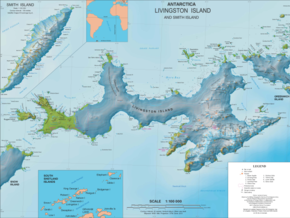 Karte der Livingston-Insel mit der Johannes-Paul-II.-Halbinsel und dem Black Point | ||
| Geographische Lage | ||
| ||
| Koordinaten | 62° 29′ S, 60° 43′ W | |
| Lage | Livingston-Insel, Südliche Shetlandinseln | |
| Gewässer | Drakestraße | |
| Gewässer 2 | Spiller Cove | |

Wissenschaftler der britischen Discovery Investigations kartierten das Kap 1935 von Bord der RRS Discovery II.
Weblinks
- Black Point im Geographic Names Information System des United States Geological Survey (englisch)
- Black Point auf geographic.org (englisch)
На других языках
- [de] Black Point (Livingston-Insel)
[en] Black Point (Livingston Island)
Black Point is a rocky promontory of 38 hectares (94 acres)[1] projecting 800 m northwards from the northeast coast of Ioannes Paulus II Peninsula into Hero Bay, Livingston Island in the South Shetland Islands, Antarctica to form the east side of the entrance to Porlier Bay. The area was visited by early 19th century sealers.Текст в блоке "Читать" взят с сайта "Википедия" и доступен по лицензии Creative Commons Attribution-ShareAlike; в отдельных случаях могут действовать дополнительные условия.
Другой контент может иметь иную лицензию. Перед использованием материалов сайта WikiSort.org внимательно изучите правила лицензирования конкретных элементов наполнения сайта.
Другой контент может иметь иную лицензию. Перед использованием материалов сайта WikiSort.org внимательно изучите правила лицензирования конкретных элементов наполнения сайта.
2019-2026
WikiSort.org - проект по пересортировке и дополнению контента Википедии
WikiSort.org - проект по пересортировке и дополнению контента Википедии