geo.wikisort.org - River
The Lidder or Liddar (Urdu: لدر, romanized: liddar, Sanskrit: लम्बोदरी, romanized: Lambodarī) is a 73 km (45 mi) river situated in the Kashmir Valley of Jammu and Kashmir, India. It originates from the Kolahoi Glacier and feeds the Jhelum River in Mirgund Khanabal, at an altitude of 1,615 metres (5,299 ft).[1][2]
| Lidder River (Liddar) | |
|---|---|
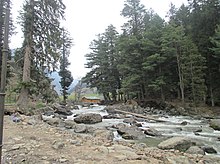
 Lidder River photographed near Lidderwat, Anantnag in 2010 | |
| Location | |
| Country | India |
| Union territory | Jammu and Kashmir |
| Region | Kashmir Valley |
| Districts | Anantnag |
| Physical characteristics | |
| Source | 34.158136°N 75.309373°E |
| • location | Kolahoi Glacier |
| • elevation | 4,653 m (15,266 ft) |
| Mouth | 33.752841°N 75.131652°E |
• location | Jhelum River at Mirgund Khanabal |
• elevation | 1,615 m (5,299 ft) |
| Length | 73 km (45 mi) |
| Discharge | |
| • average | 206 m3/s (7,300 cu ft/s) |
Etymology
Lidder is a corruption of the local Sanskrit name Lambodari (लम्बोदरी) meaning 'long bellied goddess'.[3]
Geography

Lidder river originates from Kolhoi Glacier near Sonamarg and gives rise to Lidder Valley. It runs southwards through the alpine meadows of Lidderwat in region of Aru, from which it got its name. It covers 30 kilometres (19 mi) before reaching Pahalgam where it the major tributary of East Lidder from Sheshnag Lake. It then runs westwards until it meets the Jehlum River at Mirgund Khanabal near Anantnag. It has crystal blueish water and Pahalgam is situated in the center of Lidder Valley.[4]
Economy
The waters of the river are mainly used for irrigation purpose through different canals and drinking through water treatment plants. There are many different varieties of fishes present in the river and a fisheries plant has been built on the banks of the river. Major types of fishes found in Lidder River are Brown trout (Salmo trutta fario) and Rainbow trout (Oncorhynchus mykiss).[5]
References
- "The geography of Jammu and Kashmir state". ikashmir.net. Retrieved 18 April 2012.
- "Khanabal village of Kashmir". fallingrain.com. Retrieved 18 April 2012.
- Gilbert, Richard Frank (1979). Young Explorers. G.H. Smith & Son. p. 157. ISBN 978-0-904775-05-1.
- "Pahalgam The Lidder Valley". ghumakkar.com. Retrieved 18 April 2012.
- "Gippsland Aquaculture Industry Network-Gain". growfish.com.au. Archived from the original on 20 February 2012. Retrieved 22 April 2012.
External links
 Media related to Lidder River at Wikimedia Commons
На других языках
[de] Lidder
Der Lidder (auch Liddar; Urdu .mw-parser-output .Arab a,.mw-parser-output a bdi.Arab{text-decoration:none!important}.mw-parser-output .Arab{font-size:120%}لدر ندی) ist ein rechter Nebenfluss des Jhelam im indischen Unionsterritorium Jammu und Kashmir.- [en] Lidder River
[ru] Лиддар
Лиддар[1] (хинди लम्बोदरी, урду لدر, англ. Lidder River) — река в Индии. Её длина составляет порядка 86,5 км[2]. Средний расход воды — 183 м³/с[3]. Высота истока — 4653 м над уровнем моря. Высота устья — 1615 м над уровнем моря[4].Другой контент может иметь иную лицензию. Перед использованием материалов сайта WikiSort.org внимательно изучите правила лицензирования конкретных элементов наполнения сайта.
WikiSort.org - проект по пересортировке и дополнению контента Википедии
