geo.wikisort.org - River
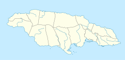
The Great River (Jamaica) is one of Jamaica's major rivers,[1] and forms the boundary of the parish of St James with Westmoreland and Hanover.[2]
| Great River (Jamaica) | |
|---|---|
| Location | |
| Country | Jamaica |
| Physical characteristics | |
| Source | |
| • coordinates | 18.207196°N 77.8835177°W |
| • elevation | 1,400 feet (430 m) |
| Mouth | |
• coordinates | 18.449568°N 77.9922867°W |
| Length | 57 miles (92 km) |
Great River
Course
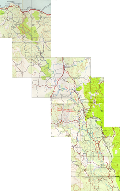
The Great River rises at about 1,400 feet (430 m) just north of the small village of Pisgah in the north west corner of St Elizabeth.[2] From here it flows north north east for about 57 miles (92 km) (some sources say 46 miles (74 km)[1]) reaching the Caribbean Sea at Great River Bay on the island's north coast, 4.5 miles (7.2 km) west of Montego Bay.[2]
Ecology
The Great River is home to the second largest tree in the island,[citation needed] and to crawfish.
Tourism
The Great River is one of the three most popular for traditional rafting on bamboo rafts.[1] It is also used for tube[3] and zip line[citation needed] craft.
See also
References
- "The Major Rivers in Jamaica". Kingston, Jamaica: National Library of Jamaica. Retrieved 10 February 2010.
- UK Directorate of Overseas Surveys 1:50,000 map of Jamaica sheet D, 1959.
- "Tubing in Jamaica". USA Today.=
- Ford, Jos C. and Finlay, A.A.C. (1908).The Handbook of Jamaica. Jamaica Government Printing Office
External links
Другой контент может иметь иную лицензию. Перед использованием материалов сайта WikiSort.org внимательно изучите правила лицензирования конкретных элементов наполнения сайта.
WikiSort.org - проект по пересортировке и дополнению контента Википедии