geo.wikisort.org - Mountains
Guaniguanico, also known as Cordillera de Guaniguanico, is a mountain range of western Cuba that spans from the centre-west of Pinar del Río Province to the western area of Artemisa Province.[1] It is formed by the subranges of Sierra del Rosario and Sierra de los Órganos.[2]
| Guaniguanico | |
|---|---|
| Cordillera de Guaniguanico | |
 Viñales Valley, part of the cordillera | |
| Highest point | |
| Peak | Pan de Guajaibón |
| Elevation | 699 m (2,293 ft) |
| Coordinates | 22°47′26.66″N 83°21′53.03″W |
| Dimensions | |
| Length | 160 km (99 mi) |
| Geography | |
 Location of Guaniguanico in Cuba | |
| Country | Cuba |
| Provinces | Pinar del Río and Artemisa |
| Range coordinates | 22°43′19″N 83°28′48″W |

Etymology
Granberry and Vescelius (2004) suggest a Guanahatabey etymology for the name Guaniguanico, comparing it with wani-wani-ku 'hidden moon, moon-set' in the purportedly related Warao language of the Orinoco Delta.[3]
Geography
The cordillera spans for a length of circa 160 km, from the town Guane, in the west of Pinar del Río Province, to the Alturas de Mariel, near Mariel, Artemisa Province. The two subranges composing it, Sierra de los Órganos (west) and Sierra del Rosario (east), are divided in the middle by the San Diego River (Río San Diego). The highest peak is the Pan de Guajaibón (699 m), located between the municipalities of Bahía Honda and La Palma. It represents a symbol of western Cuba.[2][4]
Landmarks
The Guaniguanico includes the Viñales Valley,[5] a natural reserve and World Heritage Site; and other landmarks as the waterfalls of Salto de Soroa, the nature reserve of Las Terrazas, and the protected area of Mil Cumbres.[citation needed]
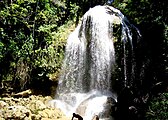 Salto de Soroa waterfall
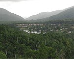 Las Terrazas natural reserve


See also
- Geography of Cuba
References
- Guaniguanico map and pictures (mapcarta.com)
- Guaniguanico at the Encyclopædia Britannica
- Granberry, Julian, & Gary Vescelius (2004). Languages of the Pre-Columbian Antilles. Tuscaloosa, AL: University of Alabama Press. ISBN 0-8173-5123-X.
{{cite book}}: CS1 maint: multiple names: authors list (link) - Pan de Guajaibón (Cuba Naturaleza website)
- "Viñales National Park on the Guaniguanico Mountain Range" (Cuba Naturaleza website)
External links
![]() Media related to Guaniguanico at Wikimedia Commons
Media related to Guaniguanico at Wikimedia Commons
Mountain ranges of Cuba | |||
|---|---|---|---|
На других языках
- [en] Guaniguanico
[es] Cordillera de Guaniguanico
La Cordillera de Guaniguanico es una cordillera en la zona noroeste de Cuba que se extiende desde la zona centro oeste de la provincia de Pinar del Río hasta la zona oeste de la provincia Artemisa.[1] Está formada por la Sierra del Rosario y Sierra de los Órganos.[2][3][fr] Cordillère de Guaniguanico
La cordillère de Guaniguanico est la principale chaîne de montagnes de la partie occidentale de Cuba. Elle est constituée de la sierra de los Órganos à l'ouest et de la sierra del Rosario à l'est, séparées par le río San Diego.[ru] Гуанигуанико
Гуанигуанико (исп. Guaniguanico) — горный массив на острове Куба, на территориях провинций Пинар-дель-Рио и Артемиса. Вторая по значимости горная система Кубы, после хребта Сьерра-Маэстра.Другой контент может иметь иную лицензию. Перед использованием материалов сайта WikiSort.org внимательно изучите правила лицензирования конкретных элементов наполнения сайта.
WikiSort.org - проект по пересортировке и дополнению контента Википедии