geo.wikisort.org - Sea
Transmarisca Bay (Bulgarian: залив Трансмариска, ‘Zaliv Transmarisca’ \'za-liv trans-ma-'ri-ska\) is the 4.3 km wide bay indenting for 3.2 km the north coast of Krogh Island in Biscoe Islands, Antarctica. It is entered east of Edholm Point and west of Kuvikal Point.
The bay is named after the ancient Roman town of Transmarisca in Northeastern Bulgaria.
Location
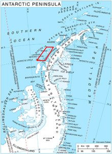
Transmarisca Bay is centred at 66°15′10″S 67°02′00″W. British mapping in 1976.
Maps
- British Antarctic Territory. Scale 1:200000 topographic map. DOS 610 Series, Sheet W 66 66. Directorate of Overseas Surveys, UK, 1976.
- Antarctic Digital Database (ADD). Scale 1:250000 topographic map of Antarctica. Scientific Committee on Antarctic Research (SCAR). Since 1993, regularly upgraded and updated.
References
- Bulgarian Antarctic Gazetteer. Antarctic Place-names Commission. (details in Bulgarian, basic data in English)
- Transmarisca Bay. SCAR Composite Antarctic Gazetteer.
External links
- Transmarisca Bay. Copernix satellite image
This article includes information from the Antarctic Place-names Commission of Bulgaria which is used with permission.
 | This Biscoe Islands location article is a stub. You can help Wikipedia by expanding it. |
Текст в блоке "Читать" взят с сайта "Википедия" и доступен по лицензии Creative Commons Attribution-ShareAlike; в отдельных случаях могут действовать дополнительные условия.
Другой контент может иметь иную лицензию. Перед использованием материалов сайта WikiSort.org внимательно изучите правила лицензирования конкретных элементов наполнения сайта.
Другой контент может иметь иную лицензию. Перед использованием материалов сайта WikiSort.org внимательно изучите правила лицензирования конкретных элементов наполнения сайта.
2019-2025
WikiSort.org - проект по пересортировке и дополнению контента Википедии
WikiSort.org - проект по пересортировке и дополнению контента Википедии