geo.wikisort.org - Sea
Tiksi Bay (Russian: Бухта Тикси, Bukhta Tiksi) is a bay of the Laptev Sea that cuts into the northern part of the Sakha Republic, Russia.
| Tiksi Bay | |
|---|---|
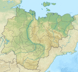 Tiksi Bay Map showing the location of Tiksi Bay | |
| Location | Far North |
| Coordinates | 71°39′N 129°8′E |
| Native name | Бухта Тикси (Russian) |
| River sources | Sogo River, Yuryage River |
| Ocean/sea sources | Laptev Sea |
| Basin countries | Russia |
| Max. length | 21 km (13 mi) |
| Max. width | 17 km (11 mi) |
| Average depth | 11 m (36 ft) |
| Settlements | Tiksi |
History
This bay was first surveyed by Russian Arctic explorer Dmitry Laptev in 1739. It was then called "Gorely Bay". The name "Tiksi Bay" was adopted in 1878.[1]
There is a cross at Tiksi Bay marking the place of death of U. S. whaling captain Thomas Long.[2]
Geography
The bay is up to 21 km long, 17 km wide[3] and has a depth of 2 to 11 metres. The Sogo and Yuryage Rivers discharge into the bay.
The port of Tiksi lies on the west side.
Semidiurnal tides in the Kola Bay are about 0.3 metres. In winter the bay is clogged by ice.
References
- Tiksi Bay / Great Soviet Encyclopedia : [in 30 vol.] / Ch. ed. A.M. Prokhorov . - 3rd ed. - M .: Soviet Encyclopedia, 1969-1978.
- Soviet Life, Issues 7-12
- GoogleEarth
- This article is based on a translation of the equivalent article of the Russian Wikipedia on 11 February 2009.
This Sakha Republic location article is a stub. You can help Wikipedia by expanding it. |
На других языках
- [en] Tiksi Bay
[ru] Тикси (бухта)
Тикси — бухта в южной части моря Лаптевых. Расположена к юго-востоку от устья реки Лена. Ширина залива у входа 17 км. Длина 21 км. Ледостав с октября по июль. Приливы величиной 30 см. Глубина до 11 м. Берег в северной части сложен льдом и рыхлыми породами.[1]Текст в блоке "Читать" взят с сайта "Википедия" и доступен по лицензии Creative Commons Attribution-ShareAlike; в отдельных случаях могут действовать дополнительные условия.
Другой контент может иметь иную лицензию. Перед использованием материалов сайта WikiSort.org внимательно изучите правила лицензирования конкретных элементов наполнения сайта.
Другой контент может иметь иную лицензию. Перед использованием материалов сайта WikiSort.org внимательно изучите правила лицензирования конкретных элементов наполнения сайта.
2019-2026
WikiSort.org - проект по пересортировке и дополнению контента Википедии
WikiSort.org - проект по пересортировке и дополнению контента Википедии