geo.wikisort.org - Sea
Mokren Bight (Bulgarian: залив Мокрен, ‘Zaliv Mokren’ \'za-liv 'mo-kren\) is a 2 km wide embayment indenting for 850 m the west coast of Astrolabe Island in Bransfield Strait off Trinity Peninsula, Antarctica. Entered northwest of Gega Point and southeast of the small peninsula featuring Petleshkov Hill, projecting westwards and ending in Damga Point to the south and Raduil Point to the north.

The bight is named after the settlement of Mokren in southeastern Bulgaria.
Location
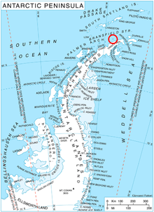
Mokren Bight is located at 63°19′14″S 58°43′08″W. German-British mapping in 1996.
Maps
- Trinity Peninsula. Scale 1:250000 topographic map No. 5697. Institut für Angewandte Geodäsie and British Antarctic Survey, 1996.
- Antarctic Digital Database (ADD). Scale 1:250000 topographic map of Antarctica. Scientific Committee on Antarctic Research (SCAR). Since 1993, regularly upgraded and updated.
References
- Mokren Bight. SCAR Composite Gazetteer of Antarctica
- Bulgarian Antarctic Gazetteer. Antarctic Place-names Commission. (details in Bulgarian, basic data in English)
External links
- Mokren Bight. Copernix satellite image
This article includes information from the Antarctic Place-names Commission of Bulgaria which is used with permission.
This Trinity Peninsula, Antarctica, location article is a stub. You can help Wikipedia by expanding it. |
Другой контент может иметь иную лицензию. Перед использованием материалов сайта WikiSort.org внимательно изучите правила лицензирования конкретных элементов наполнения сайта.
WikiSort.org - проект по пересортировке и дополнению контента Википедии