geo.wikisort.org - Sea
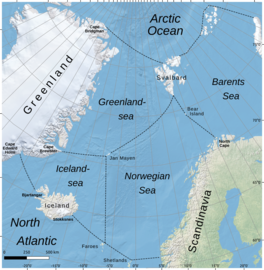
The Iceland Sea is a small body of water delimited by the Jan Mayen fracture zone to the north, Greenland to the west, the Denmark Strait to the south, and the Jan Mayen Ridge to the east. Depths usually range from 500 to 2,000 meters but can be shallower on the Continental shelf of East Greenland. The Kolbeinsey Ridge crosses the Iceland Sea, dividing it into eastern and western parts.[1]

| Iceland Sea | |
|---|---|
 Borders of Iceland Sea according to IHO draft standard (2002) | |
 Iceland Sea | |
| Coordinates | 66.923107°N 12.628921°W |
| Surface area | 406,000 km2 (157,000 sq mi) |
| Average depth | 1,026 m (3,366 ft) |
| Water volume | 417,000 km3 (100,000 cu mi) |
| Islands | None |
According to the International Hydrographic Organization, in its 1953 edition of the Limits of Oceans and Seas standard, which as of 2021 is still in force, the Greenland Sea comprises the area of the Iceland Sea.[2] The proposed 2002 edition defines the Iceland Sea as a zone of its own.[3]
Marine life
Many species of seals and whales reside in the frigid waters off Iceland's northern coast.
References
- Pálsson, Ólafur K.; Gislason, Astthor; Guðfinnsson, Hafsteinn G.; Gunnarsson, Björn; Ólafsdóttir, Sólveig R.; Petursdottir, Hildur; Sveinbjörnsson, Sveinn; Thorisson, Konrad; Valdimarsson, Héðinn (2012-09-01). "Ecosystem structure in the Iceland Sea and recent changes to the capelin (Mallotus villosus) population". ICES Journal of Marine Science. 69 (7): 1242–1254. doi:10.1093/icesjms/fss071. ISSN 1054-3139.
- Names and Limits of Oceans and Seas (PDF) (3rd ed.), Monaco: International Hydrographic Organization, 1953, 9.6–9.8, retrieved 2021-05-08
- Names and Limits of Oceans and Seas (4th ed.), Monaco: International Hydrographic Organization, 2002, 9.6 – Greenland Sea, 9.8 Iceland Sea, retrieved 2021-05-08
Другой контент может иметь иную лицензию. Перед использованием материалов сайта WikiSort.org внимательно изучите правила лицензирования конкретных элементов наполнения сайта.
WikiSort.org - проект по пересортировке и дополнению контента Википедии