geo.wikisort.org - Sea
The Gulf of Darién (UK: /ˈdɛəriən, ˈdær-/, US: /ˌdɛəriˈɛn, ˌdɑːr-, dɑːrˈjɛn/, Spanish: [daˈɾjen]) is the southernmost region of the Caribbean Sea, located north and east of the border between Panama and Colombia. Within the gulf is the Gulf of Urabá, a small lip of sea extending southward, between Caribana Point and Cape Tiburón, Colombia, on the southern shores of which is the port city of Turbo, Colombia. The Atrato River delta extends into the Gulf of Darién.[2][3][4][5][1]
| Gulf of Darién | |
|---|---|
| Spanish: Golfo de Darién | |
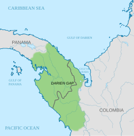 The Gulf of Darién, north of the isthmus of Darién in the Caribbean Sea | |
 Gulf of Darién Gulf of Darién in relation to Colombia | |
| Location | Caribbean Sea |
| Coordinates | 9°25′42″N 77°3′40″W |
| Type | Gulf |
| Basin countries | Colombia |
| References | [1] |
The Darien Scheme
The Gulf of Darién was the site of the Darien scheme, autonomous Scotland's one major attempt at colonialism. The first expedition of five ships (Saint Andrew, Caledonia, Unicorn, Dolphin, and Endeavour) set sail from Leith on July 14, 1698, with around 1,200 people on board.[6] Their orders were "to proceed to the Bay of Darien, and make the Isle called the Golden Island ... some few leagues to the leeward of the mouth of the great River of Darien ... and there make a settlement on the mainland".[7] After calling at Madeira and the West Indies, the fleet made landfall off the coast of Darien on November 2. The settlers christened their new home "New Caledonia".[8]
See also
- Darién Gap
- Guna people
External links
- "Ecological Damage in the Darién Gap". American.edu.
- "Papers of the Company of Scotland Trading to Africa and the Indies, 1694-1709". British Online Archvies.
- "Darien Chest". Archived from the original on 2014-09-03.
References
- "Golfo de Urabá". GeoNames. Retrieved September 10, 2021.
- "Darien". Collins English Dictionary. HarperCollins. Retrieved 23 July 2019.
- "Darien". Lexico UK English Dictionary. Oxford University Press. Archived from the original on 2020-03-22.
- "Darién". The American Heritage Dictionary of the English Language (5th ed.). HarperCollins. Retrieved 23 July 2019.
- "Darién". Merriam-Webster Dictionary. Retrieved 23 July 2019.
- McClymont, Roy. "The Darien Scheme: A Supplement". Appalachian State University, History Department. Retrieved November 14, 2015.
- Pratt Insh, George (1924). Papers Relating to the Ships and Voyages of the Company of Scotland Trading to Africa and the Indies, 1696-1707 (PDF). Edinburgh: Scottish History Society. pp. 64–65.
- Hidalgo, Dennis R. (2001). "To Get Rich for Our Homeland: The Company of Scotland and the Colonization of the Darién". CLAHR: Colonial Latin American Historical Review. 10 (3): 311–350.
- Additional sources
- Alí, Maurizio. 2010: “En estado de sitio: los kuna en Urabá. Vida cotidiana de una comunidad indígena en una zona de conflicto”. Universidad de Los Andes, Facultad de Ciencias Sociales, Departamento de Antropología. Bogotá: Uniandes. ISBN 978-958-695-531-7.
- Gallup-Diaz, Ignacio. 1999 The Door of the Seas and Key to the Universe: Indian Politics and Imperial Rivalry in the Darién, 1640-1750. New York: Columbia University Press on the Gutenberg-e project: www.gutenberg-e.org. ISBN 9780231503730
- Méndez, Horacio. (1996). La historia de mis abuelos: Textos del pueblo Tule, Panamá - Colombia. Colombia: Asociación de Cabildos Indígenas de Antioquia.
- Watt, Douglass (2006). The price of Scotland: Darien, union and the wealth of the nations. Edinburgh: Luath Press. ISBN 1909912913
- Storrs, Christopher (1999). "Disaster at Darien (1698–1700)? The Persistence of Spanish Imperial Power on the Eve of the Demise of the Spanish Habsburgs". European History Quarterly 29 (1): 5–38.
| Authority control |
|
|---|
This article about the geography of Panama is a stub. You can help Wikipedia by expanding it. |
This Colombian location article is a stub. You can help Wikipedia by expanding it. |
На других языках
- [en] Gulf of Darién
[ru] Дарьенский залив
Дарье́нский зали́в (исп. Golfo del Darién) — залив в юго-западной части Карибского моря, расположенный у берегов Панамы и Колумбии. Вдаётся в сушу на 165 км, его узкая южная часть выделяется в залив Ураба[1], расположенный между Карибана-Пойнт и мысом Тибурон. На берегу залива Ураба расположен колумбийский портовой город Турбо.Другой контент может иметь иную лицензию. Перед использованием материалов сайта WikiSort.org внимательно изучите правила лицензирования конкретных элементов наполнения сайта.
WikiSort.org - проект по пересортировке и дополнению контента Википедии