geo.wikisort.org - Sea
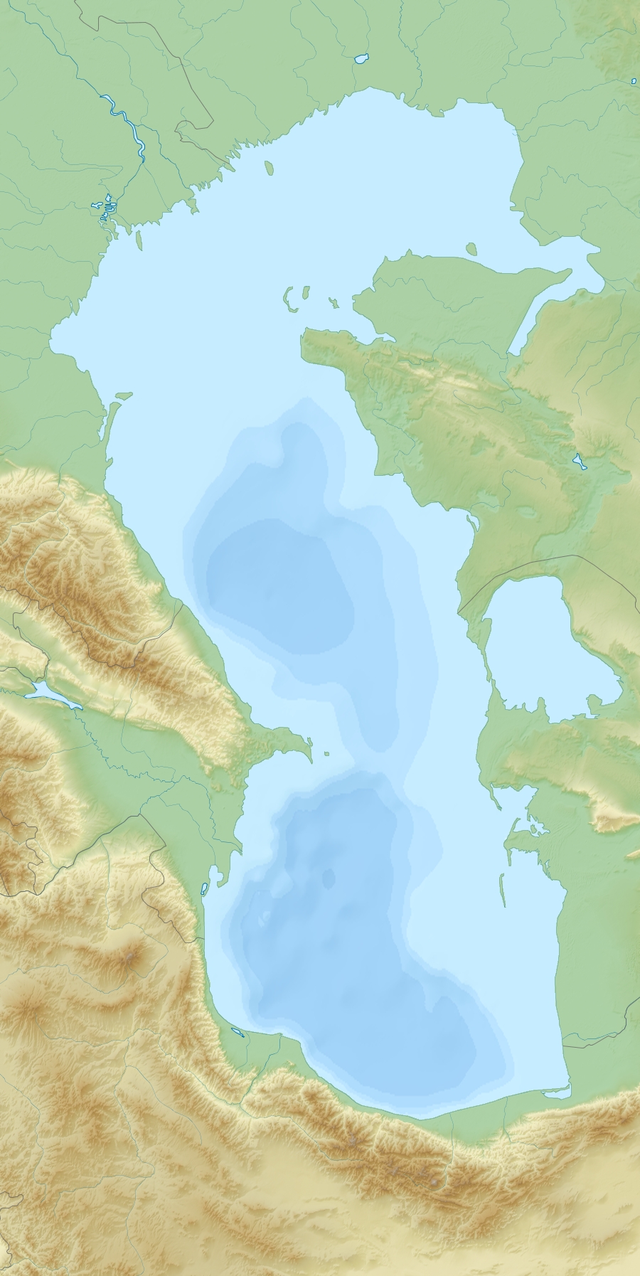
The Garabogazköl (also spelt Kara-Bogaz-Gol; "Black Strait Lake"), or Garabogazköl Aylagy ("Black Strait Lake Bay"), is a shallow, highly-saline water-filled depression in the northwestern corner of Turkmenistan.[1] It forms a lagoon of the Caspian Sea and has a variable surface area, being about 18,000 km2 (6,900 sq mi).[2] The Caspian Sea proper sits immediately to the west, mostly divorced by a narrow, rocky ridge having a very narrow opening through which the Caspian waters flow, overwhelmingly, into it. There is likely to be a subterranean highly saline flow, only when there is less evaporation in winter, as in the case of the Turkish Straits year-round. The lagoon's volume fluctuates seasonally, accentuated by its salt evaporation ponds and natural counterpart surrounding, seasonally dry salt pans.
| Garabogazköl | |
|---|---|
| Kara-Bogaz-Gol | |
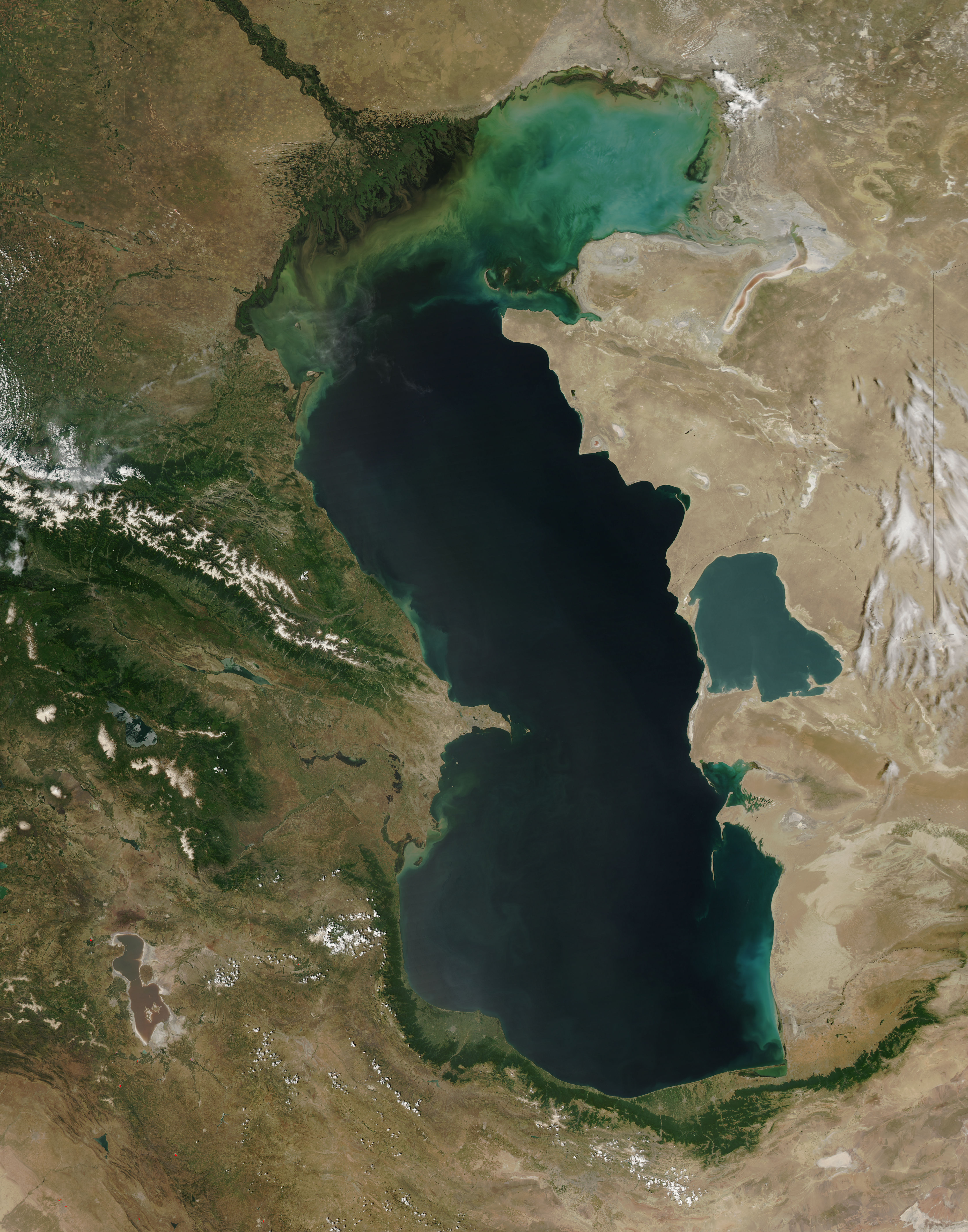
 Kara-Bogaz Gol from space, September 1995 | |
 Garabogazköl | |
| Location | |
| Coordinates | 41°21′07″N 53°35′43″E |
| Native name | Garabogazköl (Turkmen) |
The city of Garabogaz (formerly Bekdaş) lies on the ridge, about 50 km (31 mi) north of the channel between the main Caspian basin and the Garabogazköl lagoon. It has a population of about 10,000 people.
Etymology
The gulf lends its name to the nearby city of Garabogaz. Atanyyazow explains that the name originally applied to the narrow strait which connects the gulf to the Caspian Sea. Because water in the strait, termed a "throat" (Turkmen: bogaz), was darker than the water on either side, it was termed "dark" or "black" (Turkmen: gara), hence garabogaz. Over time the name was applied to the gulf itself and ultimately to the city.[3]
Salinity
The salinity of the lagoon averages about 35%, compared to the Caspian Sea's 1.2%,[4] and 3–4% for the bulk of the world's oceans. Because of the exceptionally high salinity, comparable to the Dead Sea, it has practically no marine vegetation. Large evaporite, mostly salt deposits accumulated at the south shore, were harvested by the local population since the 1920s, but in the 1930s manual collection stopped and the industry shifted northwest to its present center near Garabogaz. From the 1950s on, ground water was pumped from levels lower than the bay itself, yielding more valuable types of salts. In 1963 construction began at Garabogaz on a modern plant for increased production of salines all the year round and independently of natural evaporation. This plant was completed in 1973.
In March 1980, workers blocked the Caspian link, due to concerns evaporation was accelerating a fall in Caspian Sea.[2] The resulting "salt bowl" caused widespread problems of blowing salt,[5] reportedly poisoning the soil and causing health problems for hundreds of kilometers downwind to the east.
 Waters flow through the narrow inlet from the Caspian (left) into the Garabogazköl
 Garabogazköl is visible on the eastern shore of the Caspian Sea

Complete evaporation
From 1984 the lake was completely dry. In June 1992, when Caspian Sea levels rose again, the barrier was breached, allowing Caspian water to again refill Garabogazköl.
The remnants of the dam can be seen in the satellite photo of the inlet, near the Caspian Sea entrance.

In popular culture
It is the subject of Russian writer Konstantin Paustovsky's 1932 book Kara-Bugaz. In this he praises the setting up of the local salt industry by the Soviet government in the 1930s.[6][7][8]
In 1935 the film director Aleksandr Razumny made a film Kara-bugaz (Кара-Бугаз) based on the above book, with music by Mikhail Ippolitov-Ivanov. French communist journalist Henri Barbusse was given a sneak preview of the almost-finished film, which he praised in an article in Izvestia. The film should have been shown first to Stalin, who became unhappy when he learned of its existence. Thus it was never generally released in the Soviet Union. It had its first public screening in London in June 2010.[9]
References
- "Turkmenistan". Geo-Data: The World Geographical Encyclopedia. 2003 – via HighBeam Research.
- Kosarev, Aleksey; Kostianoy, Andrey; Zonn, Igor (2008-11-02). "Kara-Bogaz-Gol Bay: Physical and Chemical Evolution". Aquatic Geochemistry. 15 (1–2): 223–236. doi:10.1007/s10498-008-9054-z.
- Atanyýazow, Soltanşa (1980). Түркменистаның Географик Атларының Дүшүндиришли Сөзлүги [Explanatory Dictionary of Geographic Names in Turkmenistan]. Ashgabat: Ылым. p. 86.
- Aladin, Nicolai; Plotnikov, Igor (2004). Lake Basin Management Initiative - The Caspian Sea (PDF) (Report).
- Micklin, Philip P. Environmental Resources and Constraints in the Former Soviet Republics (1994). The National Council for Soviet and Eastern European Research. Page 9.
- Konstantin Paustovsky (1977). The Black Gulf. Westport, Conn. : Hyperion Press. ISBN 978-0-88355-411-1.
- Priestland, David (October 1, 2010). "Engineers of the Soul". History Today – via Highbeam Research.
- Ruch, Julie Ella (Spring 2013). "Engineers of the Soul: The Grandiose Propaganda of Stalin's Russia". Canadian Slavonic Papers. 55 (1/2): 246–247. ISSN 0008-5006.
- Westerman, Frank (8 June 2010). "Discovering Stalin's banned film". Today. BBC Radio 4. Retrieved 24 December 2019.
External links
| Authority control: National libraries |
|---|
На других языках
[de] Kara-Bogas-Gol
Der Kara-Bogas-Gol (turkmenisch: Garabogazköl, russisch Кара-Богаз-Гол), auch Karabugas-Golf, ist eine flache, ausgedehnte Lagune am Ostufer des Kaspischen Meers in Turkmenistan. Das Wasser hat eine Tiefe von 4–7 m und weist, bedingt durch starke Verdunstung, einen extrem hohen Salzgehalt von bis zu 34 % auf. Die Wasserfläche beträgt etwa 18.400 km².- [en] Garabogazköl
[es] Kara Bogaz Gol
El Kara Bogaz Kol (también llamado Garabogazköl Aylagy o Kara-Bogaz-Gol, literalmente lago de la Garganta Negra) es un accidente geográfico de Turkmenistán, país ubicado en el Asia Central, que puede considerarse tanto un lago salado, una depresión, una albufera o incluso un golfo. Se trata de una depresión de escasa profundidad, a pocos metros bajo el nivel del mar, ubicada en la zona noroccidental de Turkmenistán en la provincia de Balkan, cuya superficie aproximada es de 18 100 km². Una estrecha barra litoral arenosa la separa de las aguas del mar Caspio, lo cual provoca, en épocas en que el nivel de este mar aumenta, que la depresión se inunde, formando así un golfo. Cuando el nivel del Caspio desciende, la depresión actúa como cuenca natural de evaporación, acumulándose las sales en sus costas.[ru] Кара-Богаз-Гол
Кара́-Бога́з-Го́л (туркм. Garabogazköl — дословно «озеро чёрного пролива», до 1936 года — Кара-Бугаз) — залив-лагуна Каспийского моря на западе Туркмении, соединяющийся с Каспием одноимённым неглубоким проливом шириной до 200 м. Из-за высокой испаряемости площадь водного зеркала значительно изменяется по сезонам.Другой контент может иметь иную лицензию. Перед использованием материалов сайта WikiSort.org внимательно изучите правила лицензирования конкретных элементов наполнения сайта.
WikiSort.org - проект по пересортировке и дополнению контента Википедии