geo.wikisort.org - Sea
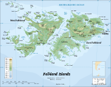
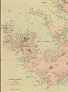
Carew Harbour[1] (former name Barnards Harbour[2]) is a 3 km (1.6 nmi) wide bay indenting for 8 km (4.3 nmi) the southwest coast of West Falkland in the Falkland Islands, South Atlantic. It is part of Queen Charlotte Bay, centered at 51.8277°S 60.7104°W
References
- Carew Harbour. Falkloand Islands. GeoNames Geographical Database
- C. Barnard, J. Nicol, J. Knights, W. Mariner and J. Bartlett. The sea, the ship and the sailor. Tales of adventure from log books and original narratives. Salem, Massachusetts: Marine Research Society, 1925 (map following p. 14)
This Falkland Islands location article is a stub. You can help Wikipedia by expanding it. |
Текст в блоке "Читать" взят с сайта "Википедия" и доступен по лицензии Creative Commons Attribution-ShareAlike; в отдельных случаях могут действовать дополнительные условия.
Другой контент может иметь иную лицензию. Перед использованием материалов сайта WikiSort.org внимательно изучите правила лицензирования конкретных элементов наполнения сайта.
Другой контент может иметь иную лицензию. Перед использованием материалов сайта WikiSort.org внимательно изучите правила лицензирования конкретных элементов наполнения сайта.
2019-2026
WikiSort.org - проект по пересортировке и дополнению контента Википедии
WikiSort.org - проект по пересортировке и дополнению контента Википедии