geo.wikisort.org - Fiume
Il Vanč (in russo Ванч) è un affluente di destra del Pjandž che scorre nella provincia autonoma del Gorno-Badachšan, nel Tagikistan orientale.
| Vanč | |
|---|---|
| Stato | |
| Lunghezza | 103 km[1] |
| Portata media | 49,4 m³/s[1] |
| Bacino idrografico | 2 070 km²[1] |
| Nasce | Versante settentrionale dei monti del Vanč 38°33′55.25″N 72°13′28.89″E |
| Sfocia | Pjandž 38°17′48.26″N 71°19′55.25″E |
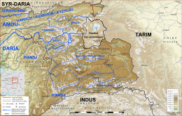 | |
Trae origine dai ghiacciai del versante settentrionale dei monti del Vanč, a nord-ovest del Picco Ismail Samani. Scorre inizialmente in direzione nord-ovest per poi svoltare verso sud-ovest, attraverso una profonda valle incassata tra le montagne del Pamir. Prima della confluenza con il Kašalajak, è noto anche come Abdukagor[1]. La valle del Vanč separa i monti del Darvaz a nord dai monti del Vanč a sud. Il fiume ha una lunghezza di 103 km e drena un'area di 2070 km². La sua portata media è di 49,4 m³/s.
Note
- (RU) Grande enciclopedia sovietica, su bse.sci-lib.com.
На других языках
[de] Wantsch
Der Wantsch (russisch Ванч) ist ein rechter Nebenfluss des Pandsch in der autonomen Provinz Berg-Badachschan im Osten von Tadschikistan.[en] Vanj (river)
The Vanj (Tajik: Ванҷ, Russian: Ванч Vanch) is a river in east Tajikistan. It is a right tributary of the Panj in Vanj District, north-western Gorno-Badakhshan. The river is 103 kilometres (64 mi) long and has a basin area of 2,070 square kilometres (800 sq mi).[1] It flows southwest between the Darvoz Range to the north and the Vanj Range to the south, joining the Panj on the border with Afghanistan. The Vanj valley is broader and more fertile than other valleys feeding the Panj. Vanj town is about 20 km upstream from the Panj. At the head of the valley, beyond the village of Po-i-Mazar, the river turns southeast (going upstream) and is fed by the Geographical Society Glacier near Independence Peak. Beyond the head of the valley are the Academy of Sciences Range and the Fedchenko Glacier.- [it] Vanč
[ru] Ванч
Ванч (также Вандж, тадж. Ванҷ,[источник не указан 627 дней] в верховьях Абдукаго́р) — река в Таджикистане, правый приток реки Пяндж. Длина реки составляет 103 км, площадь бассейна — 2070 км². Средневзвешенная высота водосбора — 3780 м. 59 % от годового стока приходится на период с июля по сентябрь. Месяц максимального стока — июль (место измерения — посёлок Ванч). Тип питания — ледниково-снеговое[1].Текст в блоке "Читать" взят с сайта "Википедия" и доступен по лицензии Creative Commons Attribution-ShareAlike; в отдельных случаях могут действовать дополнительные условия.
Другой контент может иметь иную лицензию. Перед использованием материалов сайта WikiSort.org внимательно изучите правила лицензирования конкретных элементов наполнения сайта.
Другой контент может иметь иную лицензию. Перед использованием материалов сайта WikiSort.org внимательно изучите правила лицензирования конкретных элементов наполнения сайта.
2019-2026
WikiSort.org - проект по пересортировке и дополнению контента Википедии
WikiSort.org - проект по пересортировке и дополнению контента Википедии