geo.wikisort.org - Fiume
La Truyère /tʀy'jɛʀ/ è un fiume della Francia. Scorre nei dipartimenti della Lozère, del Cantal e dell'Aveyron. È l'affluente principale del Lot, nel quale essa confluisce alla riva destra. Si tratta dunque di un subaffluente della Garonna.
| Truyère | |
|---|---|
 | |
| Stato | |
| Regioni | Alvernia-Rodano-Alpi Occitania |
| Dipartimenti |
|
| Lunghezza | 170 km[1] |
| Bacino idrografico | 3 280 km²[1] |
| Altitudine sorgente | 1 450 m s.l.m. |
| Nasce | nella Margeride |
| Sfocia | presso Entraygues-sur-Truyère nel Lot |
Percorso
Nasce nel massiccio della Margeride e dopo un percorso di 170 km[1] si getta nel Lot a valle di Entraygues-sur-Truyère.
Dipartimenti e principali comuni attraversati
- Lozère: Le Malzieu-Ville, Chaulhac, Saint-Léger-du-Malzieu, Rimeize, Blavignac, Saint-Pierre-le-Vieux, Fontans, Saint-Gal, Serverette
- Cantal: Saint-Martial, Chaliers, Oradour, Fridefont, Alleuze, Faverolles, Neuvéglise
- Aveyron: Entraygues-sur-Truyère, Thérondels, Cantoin, Montézic, Brommat
Principali affluenti
- il Torrente di Rieutortet: 8,9 km
- il Mézère: 15,5 km
- il Triboulin: 16,4 km
- la Rimeize: 37,3 km
- la Limagnole: 15,9 km
- il Torrente della Gardelle: 11,5 km
- il Torrente di Galastre: 11,5 km
- il Torrente dei Planchettes: 9,8 km
- il Torrente della Roche: 13,8 km
- il Torrente di Mongon: 0,6 km
- il Torrente di Arcomie: 19,6 km
- l'Ander: 36,2 km
- il Torrente delle Ternes: 22,6 km
- il Bès: 66,7 km
- il Torrente de Chalivet: 8,3 km
- il Remontalou: 15,4 km
- il Torrente dell'Épie: 27,6 km
- il Torrente di Lévandès: 14,9 km
- il Lebot: 22,7 km
- il Vezou: 13,1 km
- il Cantoinet: 11,4 km
- il Brezons: 28,5 km
- l'Argence: 23,9 km
- il Torrente delle Ondes: 13,3 km
- la Bromme: 28,7 km
- il Torrente dei Vergnes: 10 km
- il Torrente di Gouzou: 11,1 km
- il Goul: 52 km
- la Selves: 44,5 km
Portate medie mensili

Immagini del fiume
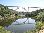 Il viadotto di Garabit che attraversa la Truyère data dagli anni 1880-84 ed è opera di Gustave Eiffel
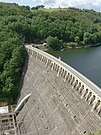 La diga di Sarrans
 La Truyère con il castello di Alleuze
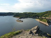 La Truyère e il lago di Grandval


Note
- (FR) SANDRE, Scheda n. O7--0250 sulla Truyère Archivio (Consultato il 3 dicembre 2013)
Altri progetti
 Wikimedia Commons contiene immagini o altri file su Truyère
| Controllo di autorità | VIAF (EN) 2684148574305224430006 · BNF (FR) cb119832761 (data) |
|---|
На других языках
[de] Truyère
Die Truyère ist ein Fluss in Frankreich der in den Regionen Okzitanien und Auvergne-Rhône-Alpes verläuft. Sie entspringt im Zentralmassiv, in der Landschaft Margeride, im Gemeindegebiet von La Villedieu, im Waldgebiet Forêt-de-la-Croix-de-Bor. Die Truyère entwässert anfangs nach Nordosten, wechselt später aber nach Südwesten, verläuft an der Grenze zum Regionalen Naturpark Aubrac und mündet nach rund 167 Kilometern am Ortsrand von Entraygues-sur-Truyère als rechter Nebenfluss in den Lot. Im Unterlauf hat der Fluss viele tief eingeschnittenen Schluchten gebildet, die durch sechs Staustufen für die Stromerzeugung genutzt werden. Auf ihrem Lauf durchquert die Truyère die Départements Lozère, Cantal und Aveyron.[en] Truyère
The Truyère (French pronunciation: [tʁy.jɛːʁ]) is a 167-kilometre-long (104 mi) river in south-western France, right tributary of the Lot.[1] Its source is in the south-western Massif Central, north of Mende. It flows generally west through the following départements and towns:[es] Río Truyère
El río Truyère es un río de Francia, afluente del río Lot por la derecha. Nace a 1.450 m sobre el nivel del mar, en el bosque de la Croix-de-Bor, en el departamento de Lozère. Desemboca en el Lot en Entraygues-sur-Truyère (Aveyron), tras un curso de 170 km. Tiene una superficie de cuenca de 3300 km².- [it] Truyère
[ru] Трюйер
Трюйер (фр. Truyère) — река в южной Франции. Длина — 170 км, площадь бассейна — 3280 км². Средний расход воды — 69,5 м³/с.[источник не указан 1772 дня]Текст в блоке "Читать" взят с сайта "Википедия" и доступен по лицензии Creative Commons Attribution-ShareAlike; в отдельных случаях могут действовать дополнительные условия.
Другой контент может иметь иную лицензию. Перед использованием материалов сайта WikiSort.org внимательно изучите правила лицензирования конкретных элементов наполнения сайта.
Другой контент может иметь иную лицензию. Перед использованием материалов сайта WikiSort.org внимательно изучите правила лицензирования конкретных элементов наполнения сайта.
2019-2026
WikiSort.org - проект по пересортировке и дополнению контента Википедии
WikiSort.org - проект по пересортировке и дополнению контента Википедии