geo.wikisort.org - Fiume
La Loue è un fiume francese che scorre nella regione della Borgogna-Franca Contea e che sfocia nel Doubs.
| Loue | |
|---|---|
 | |
| Stato | |
| Regioni | |
| Dipartimenti | Doubs Giura |
| Lunghezza | 122,2 km[1] |
| Portata media | 59,2 m³/s[2] |
| Bacino idrografico | 1 733 km²[1] |
| Altitudine sorgente | 528 m s.l.m.[1] |
| Nasce | Ouhans 47°00′40.3″N 6°17′56.48″E |
| Sfocia | Doubs 47°00′47.21″N 5°26′53.92″E |
Geografia
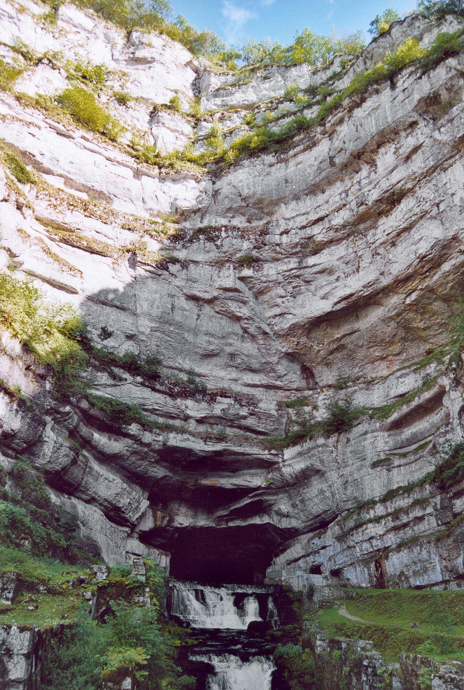
La sorgente del fiume, posta nel comune di Ouhans, è un notevole esempio di risorgiva di un corso d’acqua sotterraneo. Esso si dirige verso nord-ovest scorrendo nelle Gole di Nouailles, formate dalla Loue, e superando varie cascate. Passa per Lods ed Ornans, quindi vira verso ovest e riceve da destra la Brême. Segue ancora una valle tortuosa a causa delle rocce dure. A Châtillon-sur-Lison vi affluisce da sinistra il Lison, il tributario maggiore. La Loue prosegue allora verso nord, per poi virare bruscamente a sud-ovest a Chenecey-Buillon.
Bagna poi Quingey e più a meridione entra nel dipartimento del Giura: dopo aver ricevuto la Furieuse a Rennes-sur-Loue segna il confine tra i due dipartimenti. Da Arc-et-Senans continua in direzione ovest ed entra in pianura, riceve la Larine a Chamblay e la Cuisance a Souvans, infine si getta nel Doubs a Parcey.

Idrografia


Note
Altri progetti
 Wikimedia Commons contiene immagini o altri file su Loue
| Controllo di autorità | VIAF (EN) 44148570698224312204 · BNF (FR) cb12011666g (data) |
|---|
На других языках
[de] Loue
Die Loue ist ein Fluss im Osten Frankreichs, in der Region Bourgogne-Franche-Comté. Sie entspringt einer ergiebigen Karstquelle im Gemeindegebiet von Ouhans in 535 m Höhe, entwässert in weit ausholenden Schleifen durch den Faltenjura generell in westlicher Richtung und mündet bei Parcey in den Doubs.[en] Loue
The Loue (French pronunciation: [lu]) is a river of eastern France, a left tributary of the Doubs, which it joins downstream of Dole. It is 122 km (76 mi) long.[1] Its source is a karst spring in the Jura mountains near Ouhans, which at least partly receives its water from the Doubs. This connection with the Doubs was discovered in 1901 when a spillage from the Pernod factory into the Doubs was transmitted into the Loue .[2][es] Río Loue
El río Loue es un río de Francia, el principal afluente del río Doubs, al que aborda por la izquierda. Nace cerca de Ouhans (Doubs) y desemboca en el Doubs aguas abajo de Dole (Jura), tras un curso de 126 kilómetros. Recorre los departamentos de Doubs y Jura.- [it] Loue
Другой контент может иметь иную лицензию. Перед использованием материалов сайта WikiSort.org внимательно изучите правила лицензирования конкретных элементов наполнения сайта.
WikiSort.org - проект по пересортировке и дополнению контента Википедии