geo.wikisort.org - Fiume
La Kosa (in russo: Коса́?; in permiaco Кӧсва) è un fiume della Russia europea orientale affluente di destra della Kama (bacino idrografico del Volga). Scorre nel Territorio di Perm', nei rajon Jurlinskij, Kočëvskij e Kosinskij.
| Kosa - Коса́ | |
|---|---|
| Stato | |
| Soggetti federali | |
| Rajon | Jurlinskij, Kočëvskij, Kosinskij |
| Lunghezza | 267 km |
| Portata media | 40 m³/s, a 43 km dalla foce |
| Bacino idrografico | 10 300 km² |
| Nasce | alture della Kama 59°25′50″N 53°28′15″E |
| Sfocia | fiume Kama 60°11′55″N 55°10′08″E |
 | |
Percorso
Nasce nella sezione nord-orientale delle alture della Kama vicino al confine con l'Oblast' di Kirov, scorrendo successivamente in un territorio spesso interessato da paludi, mantenendo direzione dapprima orientale, quindi nord-orientale o settentrionale; sfocia nella Kama nel suo alto corso, a 1 109 km dalla foce, vicino al villaggio di Ust'-Kosa. La larghezza del fiume alla foce è di circa 60 metri. Non incontra lungo il suo corso centri urbani di rilievo. Ha una lunghezza di 267 km, il suo bacino è di 10 300 km².
Regime
La Kosa è gelata, in media, dai primi di novembre alla fine di aprile o al principio di maggio.
Collegamenti esterni
- (RU) Grande enciclopedia sovietica, su bse.sci-lib.com.
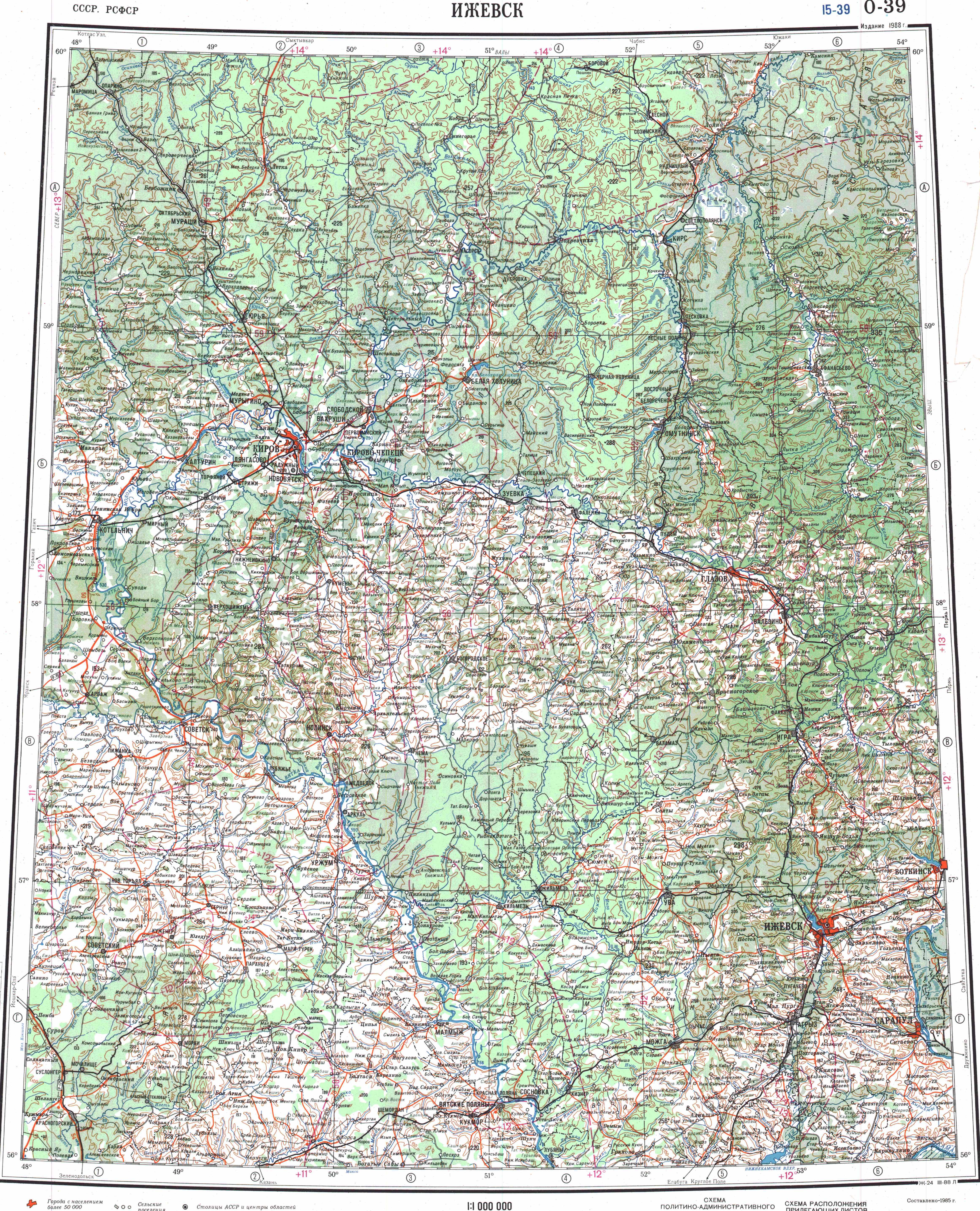
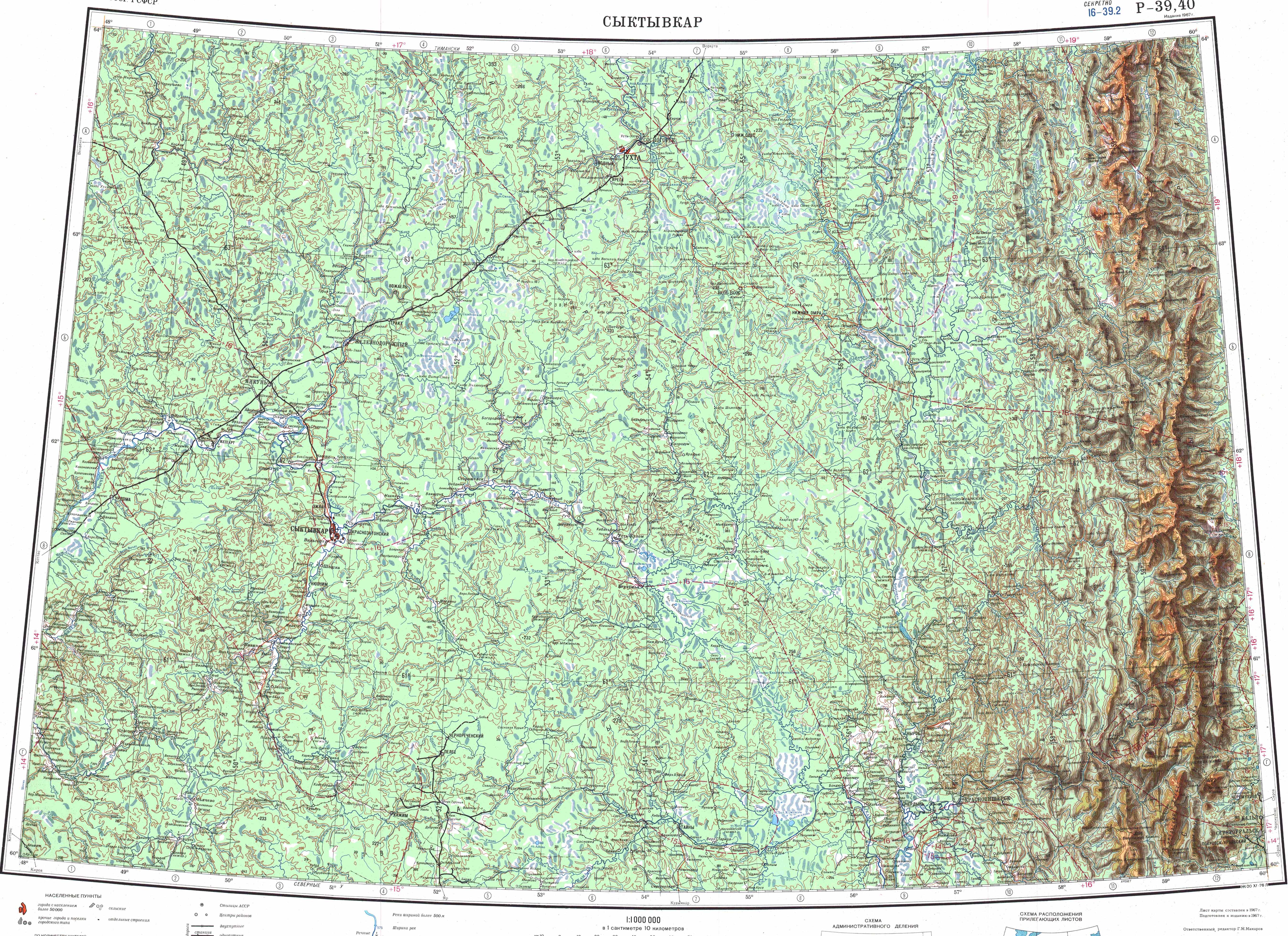
- Mappa: O-39 (JPG), su maps.vlasenko.net. URL consultato il 23 agosto 2021.; O-40 (JPG), su maps.vlasenko.net. URL consultato il 23 agosto 2021.; P-39_40 (JPG), su maps.vlasenko.net. URL consultato il 23 agosto 2021.
- (RU) Река Коса, su textual.ru. URL consultato il 23 agosto 2021.
На других языках
[de] Kossa (Kama)
Die Kossa (russisch Коса́, Komi Кӧсва) ist ein 267 km langer rechter Nebenfluss der Kama in der russischen Region Perm.[en] Kosa (river)
The Kosa (Russian: Коса, Komi: Кöсва) is a river in Perm Krai, Russia, a right tributary of the Kama.[1][2] The river is 267 kilometres (166 mi) long and has a basin of 10,300 square kilometres (4,000 sq mi).[3] The Kosa freezes up in late October or November and stays icebound until April or early May. It starts in the extreme south of Kosinsky District and flows north. The mouth of the river is near the village of Ust-Kosa. Banks are lowland. There are swamp Ydzhidnyur in the basin of the Kosa.- [it] Kosa
[ru] Коса (приток Камы)
Коса́ (коми-перм. Кӧсва) — река в Пермском крае России, правый приток Камы. Длина — 267 км. Площадь водосборного бассейна — 10 300 км². Устье находится в 1109 км по правому берегу, около деревни Усть-Коса[2].Другой контент может иметь иную лицензию. Перед использованием материалов сайта WikiSort.org внимательно изучите правила лицензирования конкретных элементов наполнения сайта.
WikiSort.org - проект по пересортировке и дополнению контента Википедии