geo.wikisort.org - Fiume
L'Eure è un fiume del nord-ovest della Francia, affluente della Senna, lungo 228,5 km.[1]
| Eure | |
|---|---|
 | |
| Stato | |
| Regioni | |
| Dipartimenti |
|
| Lunghezza | 228,7 km[1] |
| Portata media | 26,2 m³/s |
| Bacino idrografico | 5 935 km² |
| Nasce | La Lande-sur-Eure |
| Sfocia | Senna, presso Saint-Pierre-lès-Elbeuf 49°19′05.16″N 0°57′00″E |
 | |
Percorso
Nasce a Marchainville, nel dipartimento dell'Orne, e sfocia presso Martot, nella Senna, dopo aver bagnato località come Chartres, Maintenon, Pacy-sur-Eure e Louviers.
Principali affluenti
- Riva destra:
- l'Aunay,
- la Drouette,
- la Maltorne,
- la Vesgre.
- Riva sinistra:
Dipartimenti e comuni attraversati
Da monte verso valle:
- Orne
- Moulicent, Longny-au-Perche, La Lande-sur-Eure, Neuilly-sur-Eure, Les Menus.
- Eure-et-Loir
- Manou, Fontaine-Simon, Belhomert-Guehouville, Saint-Maurice-Saint-Germain, Pontgouin, Courville-sur-Eure, Saint-Georges-sur-Eure, Fontenay-sur-Eure, Thivars, Loché (frazione di Ver-lès-Chartres), Chartres, Saint-Prest, Jouy, Saint-Piat, Maintenon, Nogent-le-Roi, Chaudon, Villemeux-sur-Eure, Le Mesnil-Ponceau (frazione di Villemeux-sur-Eure), Charpont, Écluzelles, Mézières-en-Drouais, Sainte-Gemme-Moronval, Cherisy, Montreuil, Sorel-Moussel, Anet, La Chaussée-d'Ivry.
- Eure
- Saint-Georges-Motel, Marcilly-sur-Eure, Croth, Ézy-sur-Eure, Ivry-la-Bataille, Garennes-sur-Eure, Bueil, Neuilly, Breuilpont, Hécourt, Merey, Gadencourt, Pacy-sur-Eure, Saint-Aquilin-de-Pacy, Ménilles, Cocherel (frazione di Houlbec-Cocherel), Chambray, Autheuil-Authouillet, Crèvecœur (frazione di La Croix-Saint-Leufroy), Heudreville-sur-Eure, Acquigny, Louviers, Le Vaudreuil, Pont-de-l'Arche, Martot.
Portate medie mensili

Immagini dell'Eure
 L'Eure alla confluenza con la Senna
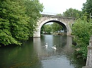 L'Eure presso i Grands Prés a Chartres, Eure e Loira.
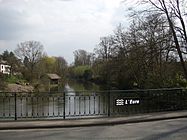 L'Eure a Cocherel, comune d'Houlbec-Cocherel, dipartimento dell'Eure.


Note
- (FR) SANDRE, Scheda del fiume Archivio (Colsultato il 14 ottobre 2013)
Voci correlate
Altri progetti
 Wikimedia Commons contiene immagini o altri file su Eure
Collegamenti esterni
- (EN) Eure, su Enciclopedia Britannica, Encyclopædia Britannica, Inc.
| Controllo di autorità | VIAF (EN) 172821378 · BNF (FR) cb124990721 (data) |
|---|
На других языках
[en] Eure (river)
The Eure (English: /ɜːr/; French pronunciation: [œʁ] (listen)) is a river between Normandy and Centre-Val de Loire in north-western France, left tributary of the Seine.[1] It is 229 km (142 mi) long.[2] It rises at Marchainville in the Orne department and joins the Seine near Pont-de-l'Arche.[2] Two departments are named after the Eure, namely Eure and Eure-et-Loir.[es] Río Eure
El río Eure (en tiempo antiguo Autura) es un río de Francia, afluente por la izquierda del río Sena. Nace en el Etang de Rumien (en el departamento de Orne), a 250 m sobre el nivel del mar, y desagua en el río Sena en Martot (departamento del Eure), aunque discurren prácticamente juntos desde Pont-de-l'Arche, tras un curso de 225 km. Su cuenca comprende una superficie de 5.935 km².- [it] Eure (fiume)
[ru] Эр (приток Сены)
Эр (фр. Eure) — река на севере Франции, левый приток Сены. Длина 226 км.[1]Текст в блоке "Читать" взят с сайта "Википедия" и доступен по лицензии Creative Commons Attribution-ShareAlike; в отдельных случаях могут действовать дополнительные условия.
Другой контент может иметь иную лицензию. Перед использованием материалов сайта WikiSort.org внимательно изучите правила лицензирования конкретных элементов наполнения сайта.
Другой контент может иметь иную лицензию. Перед использованием материалов сайта WikiSort.org внимательно изучите правила лицензирования конкретных элементов наполнения сайта.
2019-2026
WikiSort.org - проект по пересортировке и дополнению контента Википедии
WikiSort.org - проект по пересортировке и дополнению контента Википедии