geo.wikisort.org - Fiume
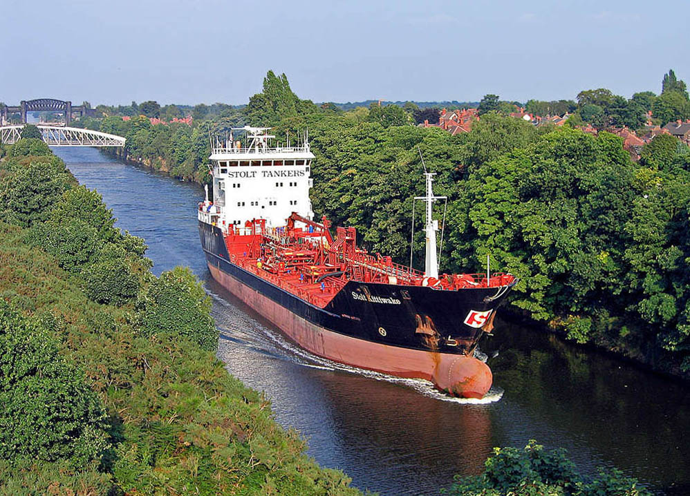
Il canale marittimo di Manchester (in inglese: Manchester Ship Canal) è un canale di 58 chilometri nel nord-ovest dell'Inghilterra. Progettato per fornire alla città di Manchester l'accesso diretto al Mare d'Irlanda, fu costruito tra il 1887 e il 1894 ad un costo di 15 milioni di sterline (che nel 2010 è 1,27 miliardi di sterline) e è quindi il canale navigabile più lungo del mondo.
| Canale marittimo di Manchester Manchester Ship Canal | |
|---|---|
 | |
| Stato | |
| Lunghezza | 58 km |
Il canale segue i fiumi Mersey e Irwell per la maggior parte del suo percorso ed è costellato da numerose chiuse. Vari tipi di imbarcazioni possono prenderlo, dalla piccola imbarcazione costiera al cargo intercontinentale, ma non è abbastanza largo per le navi moderne.
Il canale non è più considerato un'importante rotta di trasporto, ma continua a trasportare 6 milioni di tonnellate di merci ogni anno. Dal 1993 è gestito da un proprietario privato.
Bibliografia
- William Albert, The Turnpike Road System in England, Cambridge University Press, 2007 (ISBN 0-521-03391-8)
- William Henry Chaloner, Industry and Innovation: Selected Essays, Routledge, 1990, 174–192 p. (ISBN 978-0-7146-3335-0)
- Jane Cumberlidge, Inland Waterways of Great Britain, Imray Laurie Norie and Wilson, 2009 (ISBN 978-1-84623-010-3)
- D. A. Farnie, The Manchester Ship Canal and the rise of the Port of Manchester, Manchester University Press, 1980 (ISBN 0-7190-0795-X)
- Ted Gray, A Hundred Years of the Manchester Ship Canal, Aurora Publishing, 1993 (ISBN 1-85926-030-6)
- Ted Gray, Manchester Ship Canal, Sutton Publishing, 1997 (ISBN 0-7509-1459-9)
- Ian Harford, Manchester and its Ship Canal Movement, Ryburn Publishing, 1994 (ISBN 1-85331-075-1)
- Duncan Haws, Merchants Fleets No.38 Manchester Liners etc, Duncan Haws, 2000 (ISBN 0-946378-39-8)
- InCom Working Group 16, Standardization of ships and inland waterways for river/sea navigation, The World Association for Waterborne Transport Infrastructure, mai 1996
- Ray King, Detonation: Rebirth of a City, Clear Publications, 2006 (ISBN 0-9552621-0-0)
- Niall Kirkwood, Manufactured Sites: Rethinking the Post-Industrial Landscape, Taylor & Francis, 2004 (ISBN 978-0-415-24365-0)
- Robert Nicholls, Trafford Park: The First Hundred Years, Phillimore & Co, 1996 (ISBN 1-86077-013-4)
- David Owen, The Manchester Ship Canal, Manchester University Press, 1983 (ISBN 0-7190-0864-6)
- John J. Parkinson-Bailey, Manchester: An Architectural History, 2000 (ISBN 0-7190-5606-3)
- Robert William Rennison, Civil Engineering Heritage: Northern England, Thomas Telford, 1996 (ISBN 978-0-7277-2518-9)
- Robert B. Stoker, The Saga of Manchester Liners, Kinglish Ltd, 1985 (ISBN 0-9507480-2-1)
- The Monopolies and Mergers Commission, Eurocanadian Shipholdings Limited and Furness, Withy & Company, Limited and Manchester Liners Limited: A Report on the Existing and Proposed Mergers, Competition Commission, 1976, PDF (lire en ligne [archive])
- James Wheeler, Manchester: Its Political, Social and Commercial History, Ancient and Modern, Whittaker and Co., 1836
- Willan, Thomas Stuart; Ratcliffe, Barrie M., Trade and transport: essays in economic history in honour of T. S. Willan, Manchester University Press, 1977 (ISBN 0-8476-6013-3)
- Cyril Wood, Manchester's Ship Canal: The Big Ditch, Tempus Publishing Ltd, 2005 (ISBN 978-0-7524-2811-6)
Altri progetti
 Wikimedia Commons contiene immagini o altri file su Canale marittimo di Manchester
Collegamenti esterni
- (EN) Canale marittimo di Manchester una breve Storia (PDF; 402 kB)
- (EN) Portando il mare a Manchester - Il bisogno di un "Big Ditch" da The Transport Archive
| Controllo di autorità | VIAF (EN) 148271837 · ISNI (EN) 0000 0001 2226 4734 · WorldCat Identities (EN) lccn-n82151640 |
|---|
На других языках
[de] Manchester Ship Canal
Der Manchester Ship Canal ist ein Kanal mit 58 km Länge im Nordwesten von England. Südlich von Liverpool an der Mündung des River Mersey in die Irische See beginnend, folgt er dem Verlauf des Flusses sowie des River Irwell bis Manchester. Das auffälligste Bauwerk des Kanals ist der Barton Swing Aqueduct.[en] Manchester Ship Canal
The Manchester Ship Canal is a 36-mile-long (58 km) inland waterway in the North West of England linking Manchester to the Irish Sea. Starting at the Mersey Estuary near Liverpool, it generally follows the original routes of the rivers Mersey and Irwell through the historic counties of Cheshire and Lancashire. Several sets of locks lift vessels about 60 feet (18 m) to the canal's terminus in Manchester. Landmarks along its route include the Barton Swing Aqueduct, the world's only swing aqueduct, and Trafford Park, the world's first planned industrial estate and still the largest in Europe.[es] Canal marítimo de Mánchester
El canal marítimo de Mánchester (en inglés: Manchester Ship Canal) es una vía navegable interior de 58 km (36 mi) en el noroeste de Inglaterra que une Mánchester con el mar de Irlanda. Partiendo del estuario del Mersey, cerca de Liverpool, sigue generalmente las rutas originales de los ríos Mersey e Irwell a través de los condados históricos de Cheshire y Lancashire. Varios juegos de esclusas elevan los buques unos 18 m (60 pies) hasta Mánchester, donde se construyó la terminal del canal. Entre los principales hitos de su ruta se encuentran el acueducto giratorio de Barton, el único acueducto giratorio del mundo, y Trafford Park, el primer polígono industrial planificado del mundo y aún hoy el más grande de Europa.- [it] Canale marittimo di Manchester
[ru] Манчестерский канал
Манчестерский канал (англ. Manchester Ship Canal) — судоходный канал в Великобритании.Другой контент может иметь иную лицензию. Перед использованием материалов сайта WikiSort.org внимательно изучите правила лицензирования конкретных элементов наполнения сайта.
WikiSort.org - проект по пересортировке и дополнению контента Википедии