geo.wikisort.org - Fiume
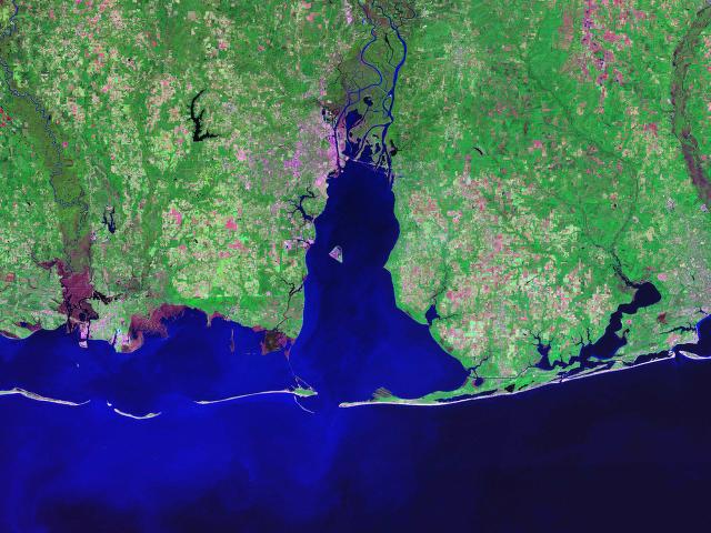
La baia di Mobile è una baia nello Stato di Alabama negli Stati Uniti. L'insenatura, situata all'estuario del fiume Mobile e del fiume Tensaw nella città di Mobile, si affaccia sul golfo del Messico. Le sue appartengono prevalentemente alla contea di Mobile e in piccola parte alla contea di Baldwin.
| Mobile Bay | |
|---|---|
 | |
| Parte di | Golfo del Messico |
| Stato | |
| Stato federato | |
| Contea | Contea di Mobile Contea di Baldwin |
| Coordinate | 30°30′22″N 87°59′24″W |
| Dimensioni | |
| Superficie | 1.070 km² |
| Lunghezza | 50 km |
| Larghezza | 39 km |
| Profondità massima | 23 m |
| Profondità media | 3 m |
 Mobile Bay | |
Descrizione
Essa è il quarto maggior estuario degli Stati Uniti con una portata di 1800 m3 di acqua al secondo.[1] Annualmente, e spesso parecchie volte in estate, pesci e crostacei sciamano lungo le poco profonde coste e le spiagge della baia. Questo evento, chiamato "anniversario della baia di Mobile", attira gran folla a causa dell'abbondanza di pesce fresco di facile cattura.
La baia di Mobile si estende su una superficie di 1070 km2, con una lunghezza di 50 km e una larghezza massima di 39.[1] I punti più profondi della baia si trovano nel canale navigabile, fino a oltre 23 metri di profondità, ma la profondità media è di 3 metri.[1]
Questa baia è ricordata per la battaglia di Mobile Bay, che ebbe luogo il 5 agosto 1864.
Note
- (EN) Estuarium Exhibits: Mobile Bay, in "Dauphin Island Sea Lab". URL consultato l'8 febbraio 2008 (archiviato dall'url originale il 22 febbraio 2008).
Altri progetti
 Wikimedia Commons contiene immagini o altri file su Mobile Bay
Collegamenti esterni
- (EN) Baia di Mobile, su Enciclopedia Britannica, Encyclopædia Britannica, Inc.
| Controllo di autorità | LCCN (EN) sh87007056 |
|---|
На других языках
[en] Mobile Bay
Mobile Bay (/moʊˈbiːl/ moh-BEEL) is a shallow inlet of the Gulf of Mexico, lying within the state of Alabama in the United States. Its mouth is formed by the Fort Morgan Peninsula on the eastern side and Dauphin Island, a barrier island on the western side. The Mobile River and Tensaw River empty into the northern end of the bay, making it an estuary. Several smaller rivers also empty into the bay: Dog River, Deer River, and Fowl River on the western side of the bay, and Fish River on the eastern side. Mobile Bay is the fourth largest estuary in the United States with a discharge of 62,000 cubic feet (1,800 m3) of water per second.[1] Annually, and often several times during the summer months, the fish and crustaceans will swarm the shallow coastline and shore of the bay. This event, appropriately named a jubilee, draws a large crowd because of the abundance of fresh, easily caught seafood.- [it] Baia di Mobile
[ru] Мобил (залив)
Залив Мобил[1] или Бухта Мобил (исп. La bahía del Mobile, англ. Mobile Bay) — внутренний залив Мексиканского залива, находится на территории штата Алабама, США. Вход в залив ограничен с востока Фортом Морган расположенном на самом краю морского выступа, а с запада островом Дофин-Айленд, являющимся одним из барьерных островов Мексиканского залива. В северной части залива находится устье реки Мобил и её притока Тенсо, помимо них в залив впадает ещё несколько небольших рек. Залив Мобил является четвёртым по размерам эстуарием на территории США с водоизмещением порядка 1800 м³ в секунду.Другой контент может иметь иную лицензию. Перед использованием материалов сайта WikiSort.org внимательно изучите правила лицензирования конкретных элементов наполнения сайта.
WikiSort.org - проект по пересортировке и дополнению контента Википедии