geo.wikisort.org - Fiume
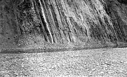
L'Anaktuvuk è un fiume di 209 km dell'Alaska settentrionale. Il primo studio cartografico e geologico dell'alveo del fiume è stato effettuato durante l'estate del 1901 dal geologo F.C. Schrader e dal topografo W.J. Peters. I due discesero il fiume Anaktuvuk in canoa fino al congiungimento col fiume Colville.[1]
| Anaktuvuk | |
|---|---|
 | |
| Stato | |
| Stati federati | |
| Lunghezza | 209 km |
| Altitudine sorgente | 1 835 m s.l.m. |
| Nasce | Endicott Mountains |
| Sfocia | fiume Colville |
Incendio del 2007 e studi sul riscaldamento globale
Nel 2007, lungo il fiume Anaktuvuk si è sviluppato un ampio incendio, studiato per le sue particolari caratteristiche: erano probabilmente secoli che non si verificavano incendi in quella zona. L'incendio in totale ha bruciato 900 chilometri quadrati di uno spesso strato di muschi accumulatosi nei cinquanta anni precedenti. In totale si stima che siano state liberate 7 milioni di tonnellate di CO2. Il riscaldamento globale renderà sempre più numerosi incendi estivi in zone prima meno interessate da questi fenomeni almeno su larga scala (Canada, Siberia, Alaska). Il pericolo maggiore deriva dal fatto che il permafrost è ricco di materia organica, spesso accumulata nei decenni, la combustione della stessa in futuro potrebbe giocare un ruolo significativo nella produzione di anidride carbonica e conseguentemente nel riscaldamento globale.[2][3]
Geografia
Il fiume trae la sua origine dalle Endicott Mountains e sfocia nel fiume Colville di cui è tributario.
Note
- Mull, Charles G. et al. (2004) Geologic Map of the Umiat Quadrangle, Alaska Scientific Investigations U.S. Department of the Interior Map 2817–A, United States Geological Survey.
- (EN) Michelle Mack ed al., Carbon loss from an unprecedented Arctic tundra wildfire, Nature 475, 489–492, 28 luglio 2011.
- Articolo online su libreidee.org, 23/8/11.
Voci correlate
- Passo Anaktuvuk
Altri progetti
 Wikimedia Commons contiene immagini o altri file su Anaktuvuk
Collegamenti esterni
- (EN) Anaktuvuk River, su geonames.usgs.gov, USGS. URL consultato il 31-12-2012.
На других языках
[de] Anaktuvuk River
Der Anaktuvuk River (auch Anukturuk River[2]) ist ein 215 km langer rechter Nebenfluss des Colville River in der North Slope im Norden des US-Bundesstaates Alaska.[1][en] Anaktuvuk River
The Anaktuvuk River[pronunciation?] (Inupiaq: Anaqtuuvak) is a river in Alaska's North Slope.[2] One hundred and thirty-five miles (217 km) long, it flows west from glaciers in the Endicott Mountains changing direction just north of Anaktuvuk Pass[1] to flow north to the Arctic Coastal Plain where it joins the Colville River. Its headwaters are formed by runoff from various glaciers in the Gates of the Arctic Wilderness on the slopes of Fan Mountain, Alapah Mountain and Limestack Mountain, the last of which lies on the watershed divide between the Arctic Coastal Plain and the Koyukuk River, and feeds the Anaktuvuk River via Graylime Creek. Its first major tributary is the John River which joins it at 68°12′14″N 151°36′50″W. The Nanushuk River joins it at 69°18′11″N 150°59′58″W.- [it] Anaktuvuk
[ru] Анактувук
Анактувук (англ. Anaktuvuk River) — крупная река на севере штата Аляска, США. Протекает по территории боро Норт-Слоуп.Другой контент может иметь иную лицензию. Перед использованием материалов сайта WikiSort.org внимательно изучите правила лицензирования конкретных элементов наполнения сайта.
WikiSort.org - проект по пересортировке и дополнению контента Википедии