geo.wikisort.org - Río
El río Yellowstone (en inglés: Yellowstone River) es un río del noroeste de Estados Unidos que fluye en dirección noreste a través de los estados de Wyoming, Montana y Dakota del Norte hasta desaguar en el río Misuri —del que es su cuarto más largo afluente, tras los ríos Kansas, Milk y James— cerca de Williston y del lago Sakakawea. Tiene una longitud de 1080 km y drena una cuenca de 182 000 km².
| Río Yellowstone | ||
|---|---|---|
| Yellowstone River | ||
 Yellowstone Falls en el Grand Canyon of the Yellowstone | ||
| Ubicación geográfica | ||
| Cuenca | Río Misisipi | |
| Nacimiento | n/d | |
| Desembocadura | río Misuri | |
| Coordenadas | 43°59′18″N 109°55′45″O | |
| Ubicación administrativa | ||
| País |
| |
| División |
| |
| Cuerpo de agua | ||
| Longitud | 1.080 km | |
| Superficie de cuenca | 182000 km² | |
| Caudal medio | 391 m³/s | |
| Altitud |
Nacimiento: n/d m Desembocadura: n/d m | |
| Mapa de localización | ||
 | ||
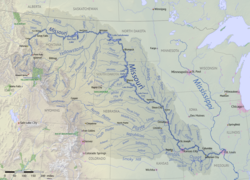 | ||
Nace en las Montañas Rocosas, en la zona del parque nacional de Yellowstone.
| Control de autoridades |
|---|
 Datos: Q374772
 Multimedia: Yellowstone River
На других языках
[de] Yellowstone River
Der Yellowstone River ist ein rechter Nebenfluss des Missouri River. Er ist 1114 Kilometer lang und fließt durch den Westen der Vereinigten Staaten. Die Hidatsa-Indianer nannten den Fluss wegen der gelben Färbung des Gesteins an seinen Ufern Mi tse a-da-zi, was die frühen französischen Trapper mit Rivière des Roches Jaunes übersetzten und Rene Jessaune im Jahre 1798 für den kanadischen Forschungsreisenden David Thompson mit Yellow Stone (englisch).[en] Yellowstone River
The Yellowstone River is a tributary of the Missouri River, approximately 692 miles (1,114 km) long, in the Western United States. Considered the principal tributary of upper Missouri, via its tributaries, it drains an area with headwaters across the mountains and high plains of southern Montana and northern Wyoming, and stretching east from the Rocky Mountains in the vicinity of Yellowstone National Park. It flows northeast to its confluence with the Missouri River on the North Dakota side of the border, about 25 miles west of present-day Williston.- [es] Río Yellowstone
[it] Yellowstone (fiume)
Lo Yellowstone è un fiume degli Stati Uniti d'America nord occidentali, che scorre per una lunghezza di circa 1.080 km, rappresentando il principale affluente dell'alto corso del fiume Missouri.[ru] Йеллоустон (река)
Йе́ллоустон[1] (англ. Yellowstone) — река на Северо-Западе США, правый приток Миссури (считается основным притоком верхнего Миссури). Длина составляет 1114 километров[2], площадь водосборного бассейна — 181 299 км²[3], а средний расход воды — 390 м³/с[4].Текст в блоке "Читать" взят с сайта "Википедия" и доступен по лицензии Creative Commons Attribution-ShareAlike; в отдельных случаях могут действовать дополнительные условия.
Другой контент может иметь иную лицензию. Перед использованием материалов сайта WikiSort.org внимательно изучите правила лицензирования конкретных элементов наполнения сайта.
Другой контент может иметь иную лицензию. Перед использованием материалов сайта WikiSort.org внимательно изучите правила лицензирования конкретных элементов наполнения сайта.
2019-2026
WikiSort.org - проект по пересортировке и дополнению контента Википедии
WikiSort.org - проект по пересортировке и дополнению контента Википедии