geo.wikisort.org - Río
El río Tao (en chino, 洮河) es un río que discurre por el centro de China, uno de los principales afluentes del río Amarillo, que le aborda por derecha en su curso superior. Tiene una longitud de 673 km.
| Río Tao | ||
|---|---|---|
| 洮河 | ||
 Embalse de Liujiaxia | ||
| Ubicación geográfica | ||
| Cuenca | Río Amarillo | |
| Nacimiento | Montañas Xiqing Shan | |
| Desembocadura | Río Amarillo | |
| Coordenadas | 35°55′00″N 103°21′00″E | |
| Ubicación administrativa | ||
| País |
| |
| División | Provincia de Gansu | |
| Cuerpo de agua | ||
| Afluentes | Lu Qu, Guangtong, Dayu y Zhuke | |
| Longitud | 673 km | |
| Superficie de cuenca | 25 527 km² | |
| Mapa de localización | ||
 | ||
Geografía
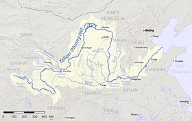
Su fuente se encuentra en las montañas Xiqing Shan (西倾山) cerca de la frontera entre las provincias de Gansu y Qinghai. Discurre hacia el este a través de la prefectura autónoma tibetana de Gannan (de Gansu), y luego hacia el norte, más o menos a lo largo de la frontera entre la prefectura-ciudad de Dingxi, en el este, y las prefecturas de Gannan y Linxia, en el oeste. Desemboca en el río Amarillo (en realidad, en el embalse de Liujiaxia), cerca de la ciudad de Liujiaxia (la sede del condado de Yongjing), justo aguas arriba de la presa Liujiaxia.
Los ríos Lu Qu, Guangtong He (广通河), Dayu He (大峪河) y Zhuke He (朱可河) pertenecen a su cuenca.
Historia
En su área de influencia se localizaron varias culturas del Neolítico y de la Edad del Bronce (véase cultura Majiayao, Cultura Banshan-Machang, Cultura Siwa, Cultura Xindian, Cultura Qijia y Cultura Tangwang).
Notas
Enlaces externos
- Esta obra contiene una traducción derivada de «Tao River» de Wikipedia en inglés, publicada por sus editores bajo la Licencia de documentación libre de GNU y la Licencia Creative Commons Atribución-CompartirIgual 3.0 Unported.
На других языках
[de] Tao He
Der Tao He (chinesisch .mw-parser-output .Hani{font-size:110%}洮河, Pinyin Táo Hé), auch Tao-Fluss genannt, ist nach Wei He einer der wichtigsten Nebenflüsse am Oberlauf des Gelben Flusses (Huang He) im Südwesten der chinesischen Provinz Gansu.[en] Tao River
Tao River (Chinese: 洮河; pinyin: Táo Hé) is a right tributary of China's Yellow River. It starts in Xiqing Mountains (西倾山) near the Gansu–Qinghai border, flows eastward across Gannan Tibetan Autonomous Prefecture, and then northward more or less along the border between Dingxi Prefecture-level City in the east and Gannan and Linxia Prefectures in the west. It flows into the Yellow River (actually, the Liujiaxia Reservoir) near Liujiaxia Town (the county seat of Yongjing County), just upstream of Liujiaxia Dam.- [es] Río Tao
[ru] Таохэ
Таохэ́[1] (кит. упр. 洮河) — река в провинциях Цинхай и Ганьсу, приток Хуанхэ, третья по величине река в провинции Ганьсу.Другой контент может иметь иную лицензию. Перед использованием материалов сайта WikiSort.org внимательно изучите правила лицензирования конкретных элементов наполнения сайта.
WikiSort.org - проект по пересортировке и дополнению контента Википедии