geo.wikisort.org - Río
El río Souris (en inglés: 'Souris River'), en francés, rivière Souris es un río que discurre por las provincias canadienses de Saskatchewan y Manitoba, y por el estado de Dakota del Norte, Estados Unidos.
| Río Souris | ||
|---|---|---|
| Souris River - Rivière Souris | ||
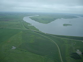 El río en la presa de Alameda (Estevan, Saskatchewan) | ||
| Ubicación geográfica | ||
| Cuenca | Río Nelson | |
| Nacimiento | Yellow Grass Marshes (Saskatchewan) | |
| Desembocadura | Río Assiniboine | |
| Coordenadas | 49°39′54″N 99°34′07″O | |
| Ubicación administrativa | ||
| País |
| |
| División |
| |
| Cuerpo de agua | ||
| Afluentes | Des Lacs, Wintering, Deep y Cut Bank | |
| Longitud | 700 km | |
| Superficie de cuenca | 45 584 km² | |
| Mapa de localización | ||
 | ||
El río Souris se origina en Yellow Grass Marshes, al norte de Weyburn, en la parte suroeste de la provincia canadiense de Saskatchewan, después fluye al sureste ingresando a Dakota del Norte, donde vira al norte para volver a entrar a Canadá, uniéndose al río Assiniboine en Manitoba después de haber recorrido unos 700 km.
En Dakota del Norte se le conoce también como río Ratón.
Tributarios
Los principales tributarios del río Souris son:
- arroyo Antler
- arroyo Gainsborough
- río Des Lacs
- río Wintering
- río Deep
- arroyo Little Deep Creek
- arroyo North Cut Bank
- arroyo South Cut Bank
- Spring Coulee
- arroyo Egg
- arroyo Livingston
- arroyo Willow
- arroyo Ox
- arroyo Snake
- arroyo Oak
Ciudades a lo largo del río
Las principales ciudades a lo largo del río son las siguientes:
- Estevan (Saskatchewan)
- Weyburn (Saskatchewan)
- Oxbow (Saskatchewan)
- Minot (Dakota del Norte)
- Burlington (Dakota del Norte)
- Velva (Dakota del Norte)
- Souris (Dakota del Norte)
- Melita (Manitoba)
- Souris (Manitoba)
| Control de autoridades |
|
|---|
 Datos: Q487925
 Multimedia: Souris River
На других языках
[de] Souris River
Der Souris River oder Mouse River (französisch bzw. englisch: Maus-Fluss) ist ein ca. 700 km langer rechter Nebenfluss des Assiniboine River.[en] Souris River
The Souris River (/ˈsʊərɪs/; French: rivière Souris) or Mouse River (as it is alternatively known in the U.S., a calque of its French name) is a river in central North America. It is about 700 km (430 mi) in length and drains about 23,600 square miles (61,100 km2). It rises in the Yellow Grass Marshes north of Weyburn, Saskatchewan. It wanders south through North Dakota beyond Minot to its most southern point at the city of Velva, and then back north into Manitoba. The river passes through the communities of Melita, Hartney, Souris and Wawanesa and on to its confluence with the Assiniboine River near Treesbank, about 25 miles (40 km) southeast of Brandon. The main tributaries which flow into the Souris in Manitoba are the Antler River, the Gainsborough, and Plum Creeks.- [es] Río Souris
[it] Souris (fiume)
Il fiume Souris, detto anche fiume Mouse (Topo), è un fiume di circa 700 km. Nasce in Canada, nella provincia del Saskatchewan a sud della città di Regina. Scorre in direzione sud-est, attraversa il confine con gli Stati Uniti puntando in direzione sud. Dopo la città di Minot, in Dakota del Nord, il suo corso punta verso nord per rientrare in Canada, nella provincia di Manitoba. Oltre confine segue definitivamente la direzione nord-est fino alla confluenza con il fiume Assiniboine presso la città di Brandon.[ru] Сурис (река)
Сури́с (англ. Souris River, фр. Souris), также Ма́ус (Mouse River) — река в Канаде, протекающая в провинциях Саскачеван и Манитоба, а также по территории США (Северная Дакота). Берёт начало на юго-востоке Саскачевана[1], впадает в реку Ассинибойн в Манитобе.Текст в блоке "Читать" взят с сайта "Википедия" и доступен по лицензии Creative Commons Attribution-ShareAlike; в отдельных случаях могут действовать дополнительные условия.
Другой контент может иметь иную лицензию. Перед использованием материалов сайта WikiSort.org внимательно изучите правила лицензирования конкретных элементов наполнения сайта.
Другой контент может иметь иную лицензию. Перед использованием материалов сайта WikiSort.org внимательно изучите правила лицензирования конкретных элементов наполнения сайта.
2019-2026
WikiSort.org - проект по пересортировке и дополнению контента Википедии
WikiSort.org - проект по пересортировке и дополнению контента Википедии