geo.wikisort.org - Río
El río Maumee[1] (en inglés Maume River) es un río del Medio Oeste de los Estados Unidos que fluye en dirección noreste por los estados de Indiana y Ohio hasta desaguar en el lago Erie, en la ciudad de Toledo. Tiene una longitud de 209 kilómetros y drena una cuenca de 16 458 km².
| Río Maumee | ||
|---|---|---|
| Maume River | ||
 El río Maumee a su paso por Toledo | ||
| Ubicación geográfica | ||
| Cuenca |
Grandes Lagos (río San Lorenzo) | |
| Nacimiento | Confluencia de los ríos St. Joseph (160 km) y St. Marys (160 km), en Fort Wayne (Indiana) | |
| Desembocadura | Lago Erie | |
| Coordenadas | 41°04′58″N 85°07′55″O | |
| Ubicación administrativa | ||
| País |
| |
| División |
| |
| Cuerpo de agua | ||
| Afluentes | Ríos Tiffin (121 km) y Auglaize (160 km) | |
| Longitud |
sólo, 209 km Con sus fuentes, 369 km | |
| Superficie de cuenca | 16.458 km² | |
| Caudal medio | 150 m³/s | |
| Altitud |
Nacimiento: 229 m Desembocadura: 173 m | |
| Mapa de localización | ||
 | ||
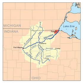 | ||
El río Maumee se forma en la ciudad de Fort Wayne (Indiana) (205 727 habs. en el Censo de 2000), por la confluencia de los ríos St. Joseph y St. Marys —ambos de 160 km de longitud—, y discurre por una región famosa por su agricultura, conocida como glacial moraines. Sus principales afluentes son los ríos Tiffin (121 km) y Auglaize (160 km). Fue declarado «Ohio State Scenic River» el 18 de julio de 1974.[2]
Referencias
- «Diccionario Webster». Consultado el 3 de junio de 2017.
- «Los Grandes Lagos». Consultado el 3 de junio de 2017.
| Control de autoridades |
|
|---|
 Datos: Q282052
 Multimedia: Maumee River
На других языках
[de] Maumee River
Der Maumee River ist ein Fluss im nordwestlichen US-Bundesstaat Ohio und wird bei Fort Wayne aus dem Zusammenfluss von St. Joseph River und St. Marys River gebildet.[en] Maumee River
The Maumee River (pronounced /mɔːˈmiː/)[1] (Shawnee: Hotaawathiipi;[2] Miami-Illinois: Taawaawa siipiiwi)[3] is a river running in the United States Midwest from northeastern Indiana into northwestern Ohio and Lake Erie. It is formed at the confluence of the St. Joseph and St. Marys rivers, where Fort Wayne, Indiana, has developed, and meanders northeastwardly for 137 miles (220 km)[4] through an agricultural region of glacial moraines before flowing into the Maumee Bay of Lake Erie. The city of Toledo is located at the mouth of the Maumee. The Maumee was designated an Ohio State Scenic River on July 18, 1974. The Maumee watershed is Ohio’s breadbasket; it is two-thirds farmland, mostly corn and soybeans. It is the largest watershed of any of the rivers feeding the Great Lakes,[5] and supplies five percent of Lake Erie’s water.[6]- [es] Río Maumee
[it] Maumee
Il Maumee è un fiume degli Stati Uniti, immissario del lago Erie.[ru] Моми (река)
Моми (англ. Maumee River) — река в США. На языке шони также известна как Hotaawathiipi.Текст в блоке "Читать" взят с сайта "Википедия" и доступен по лицензии Creative Commons Attribution-ShareAlike; в отдельных случаях могут действовать дополнительные условия.
Другой контент может иметь иную лицензию. Перед использованием материалов сайта WikiSort.org внимательно изучите правила лицензирования конкретных элементов наполнения сайта.
Другой контент может иметь иную лицензию. Перед использованием материалов сайта WikiSort.org внимательно изучите правила лицензирования конкретных элементов наполнения сайта.
2019-2026
WikiSort.org - проект по пересортировке и дополнению контента Википедии
WikiSort.org - проект по пересортировке и дополнению контента Википедии