geo.wikisort.org - Río
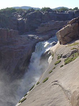
Las cataratas Augrabies (en afrikáans, Augrabieswaterval; en inglés, Augrabies Falls) son unas cascadas situadas en el curso del río Orange, en Sudáfrica, dentro del parque nacional de las Cataratas Augrabies.
| Cataratas Augrabies | ||
|---|---|---|
| Augrabieswaterval - Augrabies Falls | ||
 | ||
| Ubicación geográfica | ||
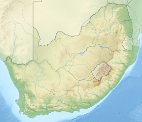
| Continente | África del Sur | |
| Área protegida | Parque nacional de las Cataratas Augrabies | |
| Río | Río Orange | |
| Cuenca | Río Orange | |
| Coordenadas | 28°35′29″S 20°20′27″E | |
| Ubicación administrativa | ||
| País |
| |
| División | Provincia Septentrional del Cabo | |
| Cuerpo de agua | ||
| N.º de caídas | 2 | |
| Volumen |
14 159 m³/s (máximo) 313 m³/s (media) | |
| Caudal medio | 3368 m³/s | |
| Altitud | 595 metros | |
| Altura total | 191 m | |
| Mapa de localización | ||
 Cataratas Augrabies | ||
Tienen en total 191 metros en dos saltos. Los residentes hotentotes originales las llamaron Ankoerebis, «el lugar de ruidos grandes», nombre del que los trekboer que se establecieron más tarde, derivaron el nombre de Augrabies.
La garganta de las cataratas Augrabies tiene 240 m de profundidad y 18 km de largo, siendo un ejemplo impresionante de erosión del granito.
Enlaces externos
 Wikimedia Commons alberga una categoría multimedia sobre Cataratas Augrabies.

| Control de autoridades |
|
|---|
 Datos: Q39544
- Multimedia: Augrabies Falls
На других языках
[en] Augrabies Falls
The Augrabies Falls /ɔːˈxrɑːbiːz/ is a waterfall on the Orange River, the largest river in South Africa. Since 1966 the waterfall, set in a desolate and rugged milieu, is enclosed by the Augrabies Falls National Park. The falls are around 183 feet (56 m) in height.[1] Some sources cite an approximate height of 480 feet; this is actually the height from the base of the canyon to the top of the walls, not that of the falls themselves.[1]- [es] Cataratas Augrabies
[ru] Ауграбис
Аугра́бис[1][2] (Aughrabies) — водопад на реке Оранжевой[2][1], в Северо-Капской провинции ЮАР. Высота 190 м[3] (непрерывного падения — 148 м[3][неавторитетный источник?], по другим данным — 146 м[3][неавторитетный источник?][4][нет в источнике][5][нет в источнике]). Расположен в 500 км от устья[3]. Потоки воды устремляются в скалистое ущелье, глубиной до 200 м и длиной 18 км.Текст в блоке "Читать" взят с сайта "Википедия" и доступен по лицензии Creative Commons Attribution-ShareAlike; в отдельных случаях могут действовать дополнительные условия.
Другой контент может иметь иную лицензию. Перед использованием материалов сайта WikiSort.org внимательно изучите правила лицензирования конкретных элементов наполнения сайта.
Другой контент может иметь иную лицензию. Перед использованием материалов сайта WikiSort.org внимательно изучите правила лицензирования конкретных элементов наполнения сайта.
2019-2026
WikiSort.org - проект по пересортировке и дополнению контента Википедии
WikiSort.org - проект по пересортировке и дополнению контента Википедии