geo.wikisort.org - River
The Zapadnaya Litsa (Russian: Западная Лица ; German: Sapadnaja Liza ; Finnish: Litsajoki) is a river in the north of the Kola Peninsula in Murmansk Oblast, Russia. It is 101 kilometres (63 mi) long, and has a drainage basin of 1,690 square kilometres (650 sq mi).[1] The Zapadnaya Litsa River originates on the Kuchintundra and flows into the Barents Sea. Its biggest tributary is the Lebyazhka River.

This article needs additional citations for verification. (April 2010) |
| Zapadnaya Litsa | |
|---|---|
 | |
 Mouth of the Zapadnaya Litsa | |
| Native name | Западная Лица (Russian) |
| Location | |
| Country | Russia |
| Region | Murmansk Oblast |
| Physical characteristics | |
| Source | |
| • location | Kuchintundra |
| • elevation | 250 m (820 ft) |
| Mouth | Barents Sea |
• coordinates | 69°25′37″N 32°16′50″E |
| Length | 101 km (63 mi) |
| Basin size | 1,690 km2 (650 sq mi) |
From 1941 to 1944, the Litsa River formed the Arctic frontline between German and Finnish troops west of the river – trying to capture Murmansk – and Soviet troops on the east, defending the city. This frontier was of vital importance for both sides, as Murmansk was the only Soviet harbour left in Europe and the northern route to Murmansk and Arkhangelsk supplied the Soviet Union with approximately 25% of all lend-lease aid.[2] During the stalemate that lasted four years, thousands perished in the tundras on both sides of the river. At the time the Litsa valley was called Death Valley (Долина смерти, Dolina smerti) by the Soviets; though later the expression Valley of Honor (Долина славы, Dolina slavy) became fashionable. The defense of Murmansk succeeded; the Germans never reached the city and the supply lines were not seriously interrupted, although the Germans bombed Murmansk to rubble from occupied Norway. See also: Operation Silver Fox and Operation Platinum Fox. The remains of the WW II fighting (trenches, pillboxes, defense pits etc.) can be visited with some specialised travel agencies.[3][4]
Memorial for the Defenders of the Soviet Arctic on Litsa River (images)
 Grave with helmet and flowers
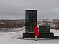 Memorial No. 1
 Memorial No. 2
 Messages by fallen soldiers
 List of names of the fallen


References
- "Река Западная Лица (Большая Лица) in the State Water Register of Russia". textual.ru (in Russian).
- http://www.feldgrau.com/econo.html Of all the lend-lease aid, approximately 50% was delivered via the Pacific, 25% via Persia and 25% via the northern route to Archangel and Murmansk.
- "Cycling Inside the Arctic Circle (KP-05). DETAILED ITINERARY -". Archived from the original on July 20, 2011. Retrieved September 6, 2010.
- "Tours in Russia". Archived from the original on November 7, 2010. Retrieved September 6, 2010.
На других языках
[de] Sapadnaja Liza (Fluss)
Die Sapadnaja Liza (russisch Западная Лица; englisch Zapadnaya Litsa) oder „Westliche Liza“ ist ein 101 km langer Fluss in der Oblast Murmansk im äußersten Nordwesten Russlands, am westlichsten Ende der Halbinsel Kola.- [en] Zapadnaya Litsa (river)
[it] Liza (fiume)
Il fiume Liza è un fiume situato nel nord della penisola di Kola, nell'oblast' di Murmansk, in Russia.[ru] Западная Лица (река)
Западная Лица (Большая Лица, Лица) — река в Мурманской области. Длина 101 км[2]. Площадь бассейна 1690 км²[2].Другой контент может иметь иную лицензию. Перед использованием материалов сайта WikiSort.org внимательно изучите правила лицензирования конкретных элементов наполнения сайта.
WikiSort.org - проект по пересортировке и дополнению контента Википедии