geo.wikisort.org - River
The Yom River (Thai: แม่น้ำยม, RTGS: Maenam Yom, pronounced [mɛ̂ː.náːm jōm]) is a river in Thailand. It is the main tributary of the Nan River (which itself is a tributary of the Chao Phraya River). The Yom River has its source in the Phi Pan Nam Range in Pong District, Phayao Province. Leaving Phayao, it flows through Phrae and Sukhothai as the main water resource of both provinces before it joins the Nan River at Chum Saeng District, Nakhon Sawan Province.
| Yom River | |
|---|---|
 Yom River in Doi Phu Nang National Park near Chiang Muan | |
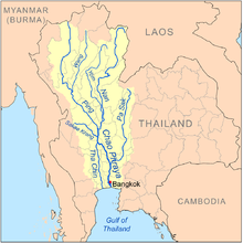 Map of the Chao Phraya River drainage basin showing the Yom River | |
| Location | |
| Country | Thailand |
| Physical characteristics | |
| Source | |
| • location | Bun Yuen village, Pong district, Phi Pan Nam Range, Phayao Province |
| • elevation | 347 m (1,138 ft) |
| Mouth | Nan River |
• location | Chum Saeng district, Nakhon Sawan province |
• elevation | 28 m (92 ft) |
| Length | 700 km (430 mi) [1] |
| Basin size | 24,047 km2 (9,285 sq mi) |
| Discharge | |
| • location | Nakhon Sawan |
| • average | 103 m3/s (3,600 cu ft/s) |
| • maximum | 1,916 m3/s (67,700 cu ft/s) |
| Basin features | |
| Tributaries | |
| • right | Ngao River |
Tributaries
Tributaries of the Yom include Nam Mae Phong, Ngao River, Nam Ngim, Huai Mae Sin, Nam Suat, Nam Pi, Mae Mok, Huai Mae Phuak, Mae Ramphan, Nam Mae Lai, Nam Khuan, and Nam Mae Kham Mi.
Yom Basin
The Yom river and its tributaries drain a total area of 24,047 square kilometres (9,285 sq mi) of land (called the Yom Basin) in the provinces of Sukhothai, Phitsanulok, Phichit, Phrae, and Lampang.[2] The Yom Basin is part of the Greater Nan Basin and the Chao Phraya Watershed.
A controversial large dam was planned on the Yom River in the central area of the Phi Pan Nam mountains in Kaeng Suea Ten in 1991 but the project was later abandoned.[3] The debate about the dam was opened again in 2011.[4] Currently a proposal is being debated to build two smaller dams on the Yom River in the area instead of the Kaeng Suea Ten mega-dam.[5]
 |
Protected areas
The Yom River flows through Mae Yom National Park in Phrae Province.
References
External links
- Living River Siam
- Bangkok Post - Living in the ugly shadow of the kaeng sua ten dam
- A Never-ending Story… Living with the Forest and Protection of the river fish
На других языках
[de] Mae Nam Yom
Der Mae Nam Yom (Thai: .mw-parser-output .Thai{font-size:115%}แม่น้ำยม, Aussprache: .mw-parser-output .IPA a{text-decoration:none}[mɛ̂ː náːm jom]), oder nur Yom, ist ein Fluss in Nord-Thailand.- [en] Yom River
[es] Mae Nam Yom
El Mae Nam Yom (Tailandés: แม่น้ำยมแม่น้ำยม), o simplemente Yom, es un río en el Norte de Tailandia.[it] Yom (fiume)
Il fiume Yom (in lingua thai: แม่น้ำยม, Maenam Yom) è il maggior affluente del Nan e scorre nella Thailandia del nord.[ru] Йом (река)
Йом (тайск. ยม) — река в Таиланде. Берёт своё начало на нагорье Фипаннам, в северной провинции Пхаяу, после чего протекает в южном направлении по Менамской низменности, где впадает в реку Нан. Общая площадь водосборного бассейна составляет около 55 тыс. км²; длина — около 600 км; расход воды — около 430 м³/с.Другой контент может иметь иную лицензию. Перед использованием материалов сайта WikiSort.org внимательно изучите правила лицензирования конкретных элементов наполнения сайта.
WikiSort.org - проект по пересортировке и дополнению контента Википедии