geo.wikisort.org - River
The Xindian River (or Xindian Creek) (Chinese: 新店溪; pinyin: Xīndiàn Xī; Wade–Giles: Hsin1-tien4 Hsi1; Pe̍h-ōe-jī: Sin-tiàm-khe) is a river in northern Taiwan. It flows through New Taipei and the capital Taipei for 82 kilometers (51 mi).[1]
This article needs additional citations for verification. (January 2009) |
| Xindian River | |
|---|---|
 Xindian River | |
| Location | |
| Country | Taiwan |
| Physical characteristics | |
| Source | |
| • location | Yingzi Mountain Range |
| • elevation | 700 m (2,300 ft) |
| Length | 81 km (50 mi) |
| Basin size | 921 km2 (356 sq mi) |
| Basin features | |
| River system | Tamsui River |
| Tributaries | |
| • left | Nanshi River |
| • right | Jingmei River, Beishi River |
Overview
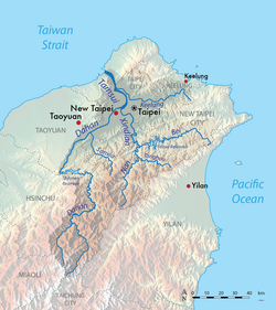
The Xindian River is one of the three major tributaries into the Tamsui River. Its main tributary is the Beishi River which originates in Shuangxi District, New Taipei City at an elevation of 700 meters (2,300 ft).[2] The Feitsui Dam spans the Beishi southeast of Taipei. It flows west past Xindian before merging with the Nanshi River; it is at this point that it becomes "Xindian River". It then turns north and merges with the Jingmei River, before finally merging with the Dahan River and feeding into the Tamsui River.
The river is one of the main sources for drinking water in Taipei City. According to the Taipei City Running Water Center, over 4 million Taipei residents obtain 97% of their drinking water from the river. The first bridge over the river was constructed in 1937 and at 200 meters (660 ft) long connected the areas of Zhonghe and Xindian. Today, there are 22 bridges that span the river.
Pollution
The Xindian River is heavily polluted by both raw sewage and industrial pollution from illegal industry.[3] [4] [5] The natural watercourse restoration is on the agenda of the Taipei City Government, Taiwan Central Government and several citizen organizations.[6]
See also
- Tamsui River
- Feitsui Dam
- List of rivers of Taiwan
References
- Reilly, Julie (1984). "The small city of Hsin Tien is, in no way, another formless suburb of Taipei". Taiwan Review. Retrieved 14 July 2014.
From every point in Hsin Tien one feels the magnetic attraction of the Hsin Tien River. It is its heart, and indeed the key to its history and development.
- 楊萬全,認識淡水河流域的水文,台灣水文論文集,2000年5月,第524頁
- Lohani, B. N.; Hee, Kee Book (1983). "A CCDP model for water quality management in the Hsintien river in Taiwan". International Journal of Water Resources Development. 1 (2): 91–114. doi:10.1080/07900628308722279.
- Chen, Lon-Gyi; Phien, Huynh Ngoc (January 1983). "Dynamo water quality modelling for the Hsintien River, Taiwan" (PDF). Water SA. 9 (1): 9.
- Lohani, B. N.; Thanh, N. C. (June 1978). "Water quality management in the Hsintien River in Taiwan". JAWRA Journal of the American Water Resources Association. 14 (3): 689–695. doi:10.1111/j.1752-1688.1978.tb02217.x.
- Taipei from the River - Marco Casagrande, E-Architect March, 2011
External links
На других языках
[de] Xindian (Fluss)
Der Xindian (chinesisch .mw-parser-output .Hant{font-size:110%}新店溪, Pinyin Xīndiànxī) ist ein Fluss im Norden der Insel Taiwan.- [en] Xindian River
[es] Río Xindian
El río Xindian (en chino: 新店溪), también denominado Xindian Creek, es un afluente de 81 km que nace próximo a Toucheng, en la zona noreste de Taiwán y desemboca en el río Tamsui cerca de la ciudad de Taipéi.[it] Xindian
Lo Xindian (cinese tradizionale: 新店溪; daighi tongiong pingim: Sindiàm ke) è un fiume di Taiwan, che scorre per 82 km a settentrione attraverso la contea e la città di Taipei. La diga Feitsui interrompe il fiume a sudest della capitale.Другой контент может иметь иную лицензию. Перед использованием материалов сайта WikiSort.org внимательно изучите правила лицензирования конкретных элементов наполнения сайта.
WikiSort.org - проект по пересортировке и дополнению контента Википедии