geo.wikisort.org - River
The Whitewater River is a small permanent stream in western Riverside County, California, with some upstream tributaries in southwestern San Bernardino County. The river's headwaters are in the San Bernardino Mountains, and it terminates at the Salton Sea in the Mojave Desert. The area drained by the Whitewater River is part of the larger endorheic Salton Sea drainage basin.
| Whitewater River | |
|---|---|
 | |
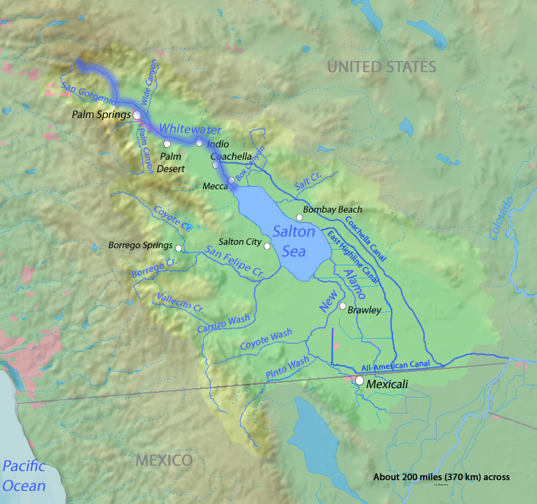 The course of the Whitewater River highlighted on a map of the Salton Sea drainage basin | |
| Location | |
| Country | United States |
| State | California |
| Cities | Palm Springs, Cathedral City, Rancho Mirage, Palm Desert, Indio, Coachella, Mecca |
| Physical characteristics | |
| Source | Confluence of North and Middle Forks [1][2] |
| • location | Near San Gorgonio Mountain, San Bernardino Mountains, San Bernardino County |
| • coordinates | 34°03′48″N 116°44′50″W[3] |
| • elevation | 4,787 ft (1,459 m) |
| Mouth | Salton Sea |
• location | South of Mecca, Riverside County |
• coordinates | 33°30′30″N 116°03′26″W[3] |
• elevation | −233 ft (−71 m) |
| Length | 53.9 mi (86.7 km)[4] |
| Basin size | 1,500 sq mi (3,900 km2) |
| Discharge | |
| • location | Indio[5] |
| • average | 3.53 cu ft/s (0.100 m3/s)[6] |
| • minimum | 0 cu ft/s (0 m3/s) |
| • maximum | 11,400 cu ft/s (320 m3/s) |
| Basin features | |
| Tributaries | |
| • left | Mission Creek,[7] Garnet Wash,[8] Thousand Palm Canyon Wash[9] |
| • right | South Fork Whitewater River,[10] San Gorgonio River, Chino Wash, Palm Canyon Wash,[11] Cathedral Canyon[12] |
National Wild and Scenic River | |
| Type | Wild, Recreational |
| Designated | March 12, 2019[13] |
Initially called Agua Blanco by early Spanish explorers,[14] and later translated into English as white water, the river received its name for its milky appearance created by the silicate and lime sediments it carries.[15] The community of Whitewater was named after the river, and became a key stop on the Bradshaw Trail stagecoach runs.
Geography
San Bernardino Mountains
The Whitewater River has three significant tributaries: the North, Middle, and South Forks, all within the Sand to Snow National Monument.
The North Fork begins in the subalpine zone at about 10,000 ft (3,000 m) on San Gorgonio Mountain and descends steeply southeast to the Middle Fork, which flows east through a wide arroyo. The South Fork flows northeast through a narrower wooded canyon, joining the Middle Fork lower down. The upper watershed is in the San Gorgonio Wilderness and San Bernardino National Forest, then it reaches land managed by the Bureau of Land Management. Below the confluences, the arroyo is at least 0.5 mi (0.80 km) wide, paved with accumulations of boulders, gravel, and sand brought down by floods and brushy except in stream channels cleared by floodwaters. Due to floods and shifting channels, there is almost no riparian forest development, except locally along unnamed minor tributaries with relatively stable channels.
The Pacific Crest Trail (PCT) enters the arroyo from the north and follows it downstream to a trailhead at the Whitewater Preserve, owned by The Wildlands Conservancy.[16] A few fish have escaped upstream, establishing a small population of wild but non-native Rainbow Trout. These fish are confined to places where there is shade or tributaries with cooler water. They are not sufficiently adapted to elevated summer temperatures to colonize the rest of the stream.
Coachella Valley
Below the PCT trailhead, the enclosing hills fall away, so the arroyo exits from the San Bernardino Mountains near Morongo Valley into the western Coachella Valley. The San Gorgonio River rises further west on the south side of San Gorgonio Mountain and then joins it. Garnet Wash, Mission Creek, Chino Canyon Wash, Palm Canyon Wash, Cathedral Canyon, and Thousand Palm Canyon Wash also join, but the water mainly penetrates through the porous desert floor, providing groundwater recharging of the Coachella Valley aquifer.
Before approaching Palm Springs, the Whitewater River is fed imported water from the Colorado River Aqueduct, managed by the Metropolitan Water District of Southern California.[17] During rare floods, surface water may reach the endorheic basin of the Salton Sea, below sea level.

Popular culture
In 2010 Huell Howser Productions, in association with KCET/Los Angeles, featured the river and nearby community in California's Gold.[18]
References
Bibliography
- Gunther, Jane Davies (1984). Riverside County, California, Place Names; Their Origins and Their Stories, Riverside, CA. LCCN 84-72920.
Citations and notes
- U.S. Geological Survey Geographic Names Information System: North Fork Whitewater River
- U.S. Geological Survey Geographic Names Information System: Middle Fork Whitewater River
- "Whitewater River". Geographic Names Information System. United States Geological Survey, United States Department of the Interior. 1981-01-19. Retrieved 2011-07-07.
- U.S. Geological Survey. National Hydrography Dataset high-resolution flowline data. The National Map, accessed March 16, 2011
- "USGS Gage #10259300 on the Whitewater River near Indio" (PDF). National Water Information System. U.S. Geological Survey. 1966. Retrieved 2011-07-07.
- "USGS Gage #10259300 on the Whitewater River near Indio" (PDF). National Water Information System. U.S. Geological Survey. 1966. Retrieved 2011-07-07.
- U.S. Geological Survey Geographic Names Information System: Mission Creek
- U.S. Geological Survey Geographic Names Information System: Garnet Wash
- U.S. Geological Survey Geographic Names Information System: Thousand Palm Canyon Wash
- U.S. Geological Survey Geographic Names Information System: South Fork Whitewater River
- U.S. Geological Survey Geographic Names Information System: Palm Canyon Wash
- U.S. Geological Survey Geographic Names Information System: Cathedral Canyon
- "Explore Designated Rivers". Rivers.gov. Retrieved January 8, 2022.
- Gunther, pp570.
- McDonnell, Lawrence R. (1970). Rivers of California. San Francisco, California: Pacific Gas and Electric Company. p. 47.
- Wildlands Conservancy Whitewater Preserve Archived October 23, 2010, at the Wayback Machine
- [dead link]
- Howser, Huell; Levy, Tom; Kenna, Jim (September 25, 2001). "Whitewater – Palm Springs Week (003)". California's Gold. Chapman University Huell Howser Archives. OCLC 47732513.
External links
- Bureau of Land Management – Whitewater resources
- The Trust for Public Land: Whitewater
- Howser, Huell (September 3, 2010). "Whitewater Preserve – California's Golden Parks (167)". California's Golden Parks. Chapman University Huell Howser Archive.
- Whitewater Canyon Earth and Biological Sciences
Другой контент может иметь иную лицензию. Перед использованием материалов сайта WikiSort.org внимательно изучите правила лицензирования конкретных элементов наполнения сайта.
WikiSort.org - проект по пересортировке и дополнению контента Википедии