geo.wikisort.org - River
West Fork Cimarron River is an 11.8-mile-long (19.0 km)[2] tributary of the Cimarron River in Colorado. The river's source is west of Coxcomb Peak in the Uncompahgre Wilderness of Hinsdale County. It joins the Cimarron River in Gunnison County.
| West Fork Cimarron River[1] | |
|---|---|
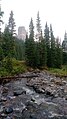
 West Fork of the Cimarron River at 10,300 ft. elevation | |
| Physical characteristics | |
| Source | |
| • location | Uncompahgre Wilderness, Hinsdale County, Colorado |
| • coordinates | 38°05′06″N 107°33′04″W |
| Mouth | |
• location | Confluence with Cimarron |
• coordinates | 38°13′36″N 107°32′20″W |
• elevation | 8,930 ft (2,720 m) |
| Basin features | |
| Progression | Cimarron—Gunnison—Colorado |
Gallery
 West Fork of the Cimarron River at 10,200 ft. elevation, with Chimney Rock in the background. Pictured at low flow in the month of August.

See also
- List of rivers of Colorado
- List of tributaries of the Colorado River
References
- "West Fork Cimarron River". Geographic Names Information System. United States Geological Survey, United States Department of the Interior. Retrieved 2011-02-14.
- U.S. Geological Survey. National Hydrography Dataset high-resolution flowline data. The National Map, accessed March 18, 2011
Текст в блоке "Читать" взят с сайта "Википедия" и доступен по лицензии Creative Commons Attribution-ShareAlike; в отдельных случаях могут действовать дополнительные условия.
Другой контент может иметь иную лицензию. Перед использованием материалов сайта WikiSort.org внимательно изучите правила лицензирования конкретных элементов наполнения сайта.
Другой контент может иметь иную лицензию. Перед использованием материалов сайта WikiSort.org внимательно изучите правила лицензирования конкретных элементов наполнения сайта.
2019-2026
WikiSort.org - проект по пересортировке и дополнению контента Википедии
WikiSort.org - проект по пересортировке и дополнению контента Википедии