geo.wikisort.org - River
The Weil (German pronunciation: [vaɪ̯l] (![]() listen)) is 46.6-kilometre-long (29.0 mi) river in Hesse, Germany. It is a left tributary to the Lahn river and the town of Weilburg is located next to its mouth. The river flows exclusively through the Taunus mountain range with its source being located between the Kleiner Feldberg and Großer Feldberg mountains. It flows through Schmitten, Weilrod and Weilmünster. A hiking trail as well as a biking trail follow the course of the river.
listen)) is 46.6-kilometre-long (29.0 mi) river in Hesse, Germany. It is a left tributary to the Lahn river and the town of Weilburg is located next to its mouth. The river flows exclusively through the Taunus mountain range with its source being located between the Kleiner Feldberg and Großer Feldberg mountains. It flows through Schmitten, Weilrod and Weilmünster. A hiking trail as well as a biking trail follow the course of the river.
| Weil | |
|---|---|
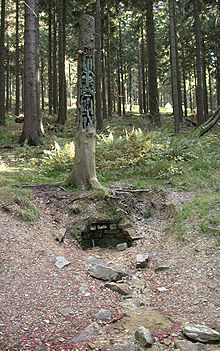
 Source of the Weil | |
| Location | |
| Country | Germany |
| State | Hesse |
| Physical characteristics | |
| Source | |
| • location | Taunus |
| • elevation | 740 m (2,430 ft) |
| Mouth | |
• location | Lahn |
• coordinates | 50°28′26″N 8°15′50″E |
| Length | 46.6 km (29.0 mi) [1] |
| Basin size | 248 km2 (96 sq mi) [1] |
| Basin features | |
| Progression | Lahn→ Rhine→ North Sea |

References
- Kümmerly+Frey: The New International Atlas. Rand McNally (1980)
External links
 Media related to Weil at Wikimedia Commons
- List of German rivers (German)
На других языках
[de] Weil (Lahn)
Die Weil im Taunus ist ein 46,6 km[3] langer, südlicher und orographisch linker Zufluss der Lahn in Hessen. Sie durchfließt den Hochtaunuskreis und den Landkreis Limburg-Weilburg.- [en] Weil (river)
[ru] Вайль (река)
Вайль (нем. Weil) — река в Германии, протекает по земле Гессен. Левый приток реки Лан.Текст в блоке "Читать" взят с сайта "Википедия" и доступен по лицензии Creative Commons Attribution-ShareAlike; в отдельных случаях могут действовать дополнительные условия.
Другой контент может иметь иную лицензию. Перед использованием материалов сайта WikiSort.org внимательно изучите правила лицензирования конкретных элементов наполнения сайта.
Другой контент может иметь иную лицензию. Перед использованием материалов сайта WikiSort.org внимательно изучите правила лицензирования конкретных элементов наполнения сайта.
2019-2025
WikiSort.org - проект по пересортировке и дополнению контента Википедии
WikiSort.org - проект по пересортировке и дополнению контента Википедии