geo.wikisort.org - River
The Weida (German: [ˈvaɪdaː] (![]() listen)) is a non-navigable river in eastern Thuringia, Germany, left tributary of the White Elster. Most of its course is situated in the district of Greiz.
listen)) is a non-navigable river in eastern Thuringia, Germany, left tributary of the White Elster. Most of its course is situated in the district of Greiz.
This article does not cite any sources. (April 2008) |
| Weida | |
|---|---|
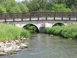
 The Weida in Lawitz | |
| Location | |
| Country | Germany |
| State | Thuringia |
| Physical characteristics | |
| Source | |
| • location | near Pausa |
| • elevation | 500 m (1,600 ft) |
| Mouth | |
• location | White Elster |
• coordinates | 50°47′44″N 12°5′21″E |
| Length | 57 km (35 mi) |
| Basin features | |
| Progression | White Elster→ Saale→ Elbe→ North Sea |
The Weida's source is near Pausa in Saxony; it then flows through the Thuringian Highland passing Zeulenroda-Triebes and through the eponymous Weida. It then feeds into the White Elster near Wünschendorf/Elster. Its tributaries include the Auma and the Leuba.
На других языках
[de] Weida (Weiße Elster)
Die Weida ist ein nicht schiffbarer Fluss im ostthüringischen Landkreis Greiz.- [en] Weida (White Elster)
[ru] Вайда (река)
Вайда (нем. Weida) — река в Германии, протекает по земле Тюрингия. Левый приток реки Вайсе-Эльстер.Текст в блоке "Читать" взят с сайта "Википедия" и доступен по лицензии Creative Commons Attribution-ShareAlike; в отдельных случаях могут действовать дополнительные условия.
Другой контент может иметь иную лицензию. Перед использованием материалов сайта WikiSort.org внимательно изучите правила лицензирования конкретных элементов наполнения сайта.
Другой контент может иметь иную лицензию. Перед использованием материалов сайта WikiSort.org внимательно изучите правила лицензирования конкретных элементов наполнения сайта.
2019-2025
WikiSort.org - проект по пересортировке и дополнению контента Википедии
WikiSort.org - проект по пересортировке и дополнению контента Википедии