geo.wikisort.org - River
The Water of Leith (Scottish Gaelic: Uisge Lìte) is the main river flowing near central Edinburgh, Scotland, and flows into the port of Leith where it flows into the sea via the Firth of Forth.
This article needs additional citations for verification. (December 2015) |
| Water of Leith | |
|---|---|
 | |
| Location | |
| Country | United Kingdom |
| Part | Scotland |
| Council areas | West Lothian, Edinburgh |
| Physical characteristics | |
| Source | |
| • location | Millstone Rig, West Lothian |
| • coordinates | 55°59′N 3°10′W |
| Mouth | |
• location | Leith Docks, Edinburgh |
• coordinates | 55.979399°N 3.170638°W |
• elevation | 0 m (0 ft) |
| Length | 35 km (22 mi) |

Name
The name Leith may be of Brittonic origin and derived from *lejth meaning 'damp, moist' (Welsh llaith).[1] It is less likely that the name derives from the Old Norse lodda meaning a river.[citation needed] The Gaelic form of the name is Lìte (Leith), with Uisge Lìte being the full translation of "Water of Leith".[2]
The Dictionary of the Scots Language defines the term "water" here as "A large stream, usu. thought of as intermediate in size between a Burn and a river"[3]
Course
This section needs additional citations for verification. (April 2022) |
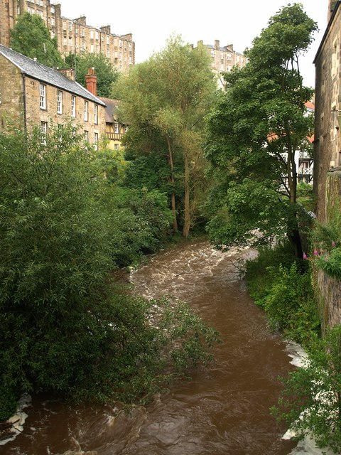
It is 35 km (22 mi) long and rises in the Colzium Springs at Millstone Rig of the Pentland Hills. It travels through Harperrig Reservoir, past the ruins of Cairns Castle, through Balerno, Currie, Juniper Green, Colinton, Slateford, Longstone, Saughton, Balgreen, Roseburn, West Coates and on to the nearest it gets to the Edinburgh city centre at the Dean Village, on the site of old watermills in a deep gorge. This ravine is dramatically spanned by the Dean Bridge, designed by Thomas Telford, which was built in 1832 for the road to Queensferry, and lies next to the New Town.

The river flows on past Stockbridge, Inverleith, Canonmills and Warriston where it passes through shallows at a place known as Puddocky which is commonly thought to refer to "puddocks", the Scots language term for frogs, but actually took its name from the former Paddock Hall which was sited nearby.[citation needed] The river continues past Bonnington, the site of another watermill, to Leith where it widens into the old harbour and port at the Shore. Leith Docks have been extended considerably out into the firth from the old shoreline, and there are now plans to discontinue their use as a port and use the area for housing redevelopment.
There is a Water of Leith Walkway beside the river for the 12.25 miles (19.71 km) from Balerno to Leith, with approximately half a mile of the route on roads.[4] The route forms an attractive haven for wildlife, passing through areas of woodland, often well separated from roads. For some distance the walkway follows the route of former railway tracks, and the remains of tunnels, bridges and other features of more than one railway may be seen at many places along the route.
A visitor centre is open to the public where the Union Canal passes over the Water of Leith via the Slateford Aqueduct at Slateford, in south-west Edinburgh. The Water of Leith Conservation Trust is dedicated to the conservation and enhancement of the river. The Trust provides education programs about the river and the environment.
Wildlife

The river is stocked with brown trout, and also contains wild grayling, eels, stone loach, minnow, three-spined stickleback and flounder. A few sea-trout run the river, and occasional Atlantic salmon are reported, although those from which scale samples have been obtained have turned out to be from other catchments. Until the weirs are either demolished or furnished with effective fish-passes, there is little chance of a population of salmon establishing themselves in this river again. Roe deer, badgers, otters and other mammals are occasionally seen.[4] The river and its environs are the haunt of a wide variety of woodland and water birds, including kingfisher, grey heron, pied wagtail, great spotted woodpecker and white-throated dipper.
See also
- Rivers of Scotland
- River Almond, which flows through Cramond and Kirkliston
- River Esk, Lothian
- Water of Leith, a river which flows through Dunedin, New Zealand
References
- James, Alan. "A Guide to the Place-Name Evidence" (PDF). SPNS - The Brittonic Language in the Old North. Retrieved 25 November 2018.
- Bell, Raymond MacKean (2017). Literary Corstorphine: A reader's guide to West Edinburgh. Edinburgh: Leamington Books. ISBN 9780244644406.
- "Water". Dictionary of the Scots Language. Retrieved 2 August 2020.
- The Water of Leith Conservation Trust. "Welcome - A silver thread in a ribbon of green". www.waterofleith.org.uk. Retrieved 14 October 2020.
External links
- Water of Leith Conservation Trust: The River, Visitor Center, Education, Conservation
- Scottish Government, 16/03/07: Water of Leith Flood Prevention Scheme
- Water of Leith
- Water of Leith Millennium Bid document. The bid was successful and paid for new sections of the Walkway and the Visitor Centre.
- "Forth District Salmon Fishery Board"
- "River Forth Fisheries Trust"
Authority control | |
|---|---|
| General |
|
| National libraries | |
На других языках
[de] Water of Leith
Das Water of Leith (schottisch-gälisch Uisge Lìte) ist der wichtigste Flusslauf von Edinburgh, Schottland. Seine Quelle befindet sich an den Hängen der Pentland Hills in West Lothian oberhalb des Staudamms Harperrig Reservoir, durch den er fließt. Danach schlängelt er sich durch ganz Edinburgh vom Vorort Balerno im Südwesten bis zum Hafen von Leith im Nordosten der Stadt, wo er nach 29 km in den Firth of Forth mündet. Sein Einzugsgebiet umfasst 117 km².[1]- [en] Water of Leith
Другой контент может иметь иную лицензию. Перед использованием материалов сайта WikiSort.org внимательно изучите правила лицензирования конкретных элементов наполнения сайта.
WikiSort.org - проект по пересортировке и дополнению контента Википедии