geo.wikisort.org - River
The Walhonding River is a principal tributary of the Muskingum River,[3] 23.5 miles (37.8 km) long,[4] in east-central Ohio in the United States. Via the Muskingum and Ohio Rivers, it is part of the watershed of the Mississippi River. It drains an area of 2,252 square miles (5,830 km2).[4]
| Walhonding River | |
|---|---|
 The Walhonding River in Warsaw in 2006 | |
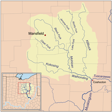 Map of the Walhonding River and its tributaries | |
| Location | |
| Country | United States |
| State | Ohio |
| County | Coshocton County |
| Physical characteristics | |
| Source | Confluence of Kokosing River and Mohican River |
| • location | Coshocton County |
| Mouth | Muskingum River |
• location | Coshocton |
| Length | 23.5 mi (37.8 km) |
| Basin size | 2,252 sq mi (5,830 km2) |
| Discharge | |
| • location | Mohawk Dam at Nellie |
| • average | 1,653.7 cu ft/s (46.83 m3/s), USGS water years 1985-1991[1] |
| Discharge | |
| • location | mouth |
| • average | 2,488.65 cu ft/s (70.471 m3/s) (estimate)[2] |

The Walhonding flows for its entire length in Coshocton County. It is formed by the confluence of the Mohican River and the Kokosing River and flows generally east-southeast,[5] passing through Mohawk Dam, which was built in the 1930s by the U.S. Army Corps of Engineers for the purpose of flood control in the Muskingum River watershed,[6] and through the towns of Nellie and Warsaw. Downstream of Warsaw it collects Killbuck Creek. It meets the Tuscarawas River at the city of Coshocton to form the Muskingum River.[5]
Variant names
According to the Geographic Names Information System, the Walhonding River has also been known historically as:[7]
- Muskingum River ("West branch")
- Walhandink River
- West Branch of the Muskingum
- White Woman Creek
- White Woman River
- White Womans Creek
- White Womans River
- Whitemans Creek
- Whitewoman Creek
- Whitewomans Creek
- Wolhonding River
The name "White Womans Creek" (and variants) was probably originally intended to refer specifically either to the Kokosing River or to the Mohican River;[8][full citation needed] and during that same period (mid-1700s), the Walhonding was known only as the "West branch of the Muskingum".[9][full citation needed] The final name "Walhonding" was newly chosen by legislators sometime after the 1820s.
See also
References
- "USGS 03138500 Walhonding River below Mohawk Dam at Nellie OH". waterdata.usgs.gov. Archived from the original on 2020-08-06. Retrieved 2020-08-06.
- United States Environmental Protection Agency. "Watershed Report: Walhonding River". watersgeo.epa.gov. Archived from the original on 2020-08-07. Retrieved 2020-08-07.
- Columbia Gazetteer of North America entry Archived 2005-08-19 at the Wayback Machine
- Ohio Department of Natural Resources. A Guide to Ohio Streams. Chapter 10: Major Ohio Watersheds (pdf) Archived 2007-02-21 at the Wayback Machine
-
- DeLorme (1991). Ohio Atlas & Gazetteer. Yarmouth, Maine: DeLorme. ISBN 0-89933-233-1
- Mohawk Dam website
- U.S. Geological Survey Geographic Names Information System: Walhonding River
- hand-drawn map circa-1815, private-collection -- which indicates that the village of "Jerometown" was on "Whitewomans Creek"
- Hutchins, Thos.; surveys and maps mid-1700s
Authority control | |
|---|---|
| General |
|
| National libraries | |
На других языках
[de] Walhonding River
Der Walhonding River ist ein 38 km langer Fluss im zentralen östlichen US-Bundesstaat Ohio; er gehört zum Flusssystem des Mississippi River. Der Abflussweg führt über Muskingum River, Ohio River und Mississippi River in den Golf von Mexiko. Der Einzugsbereich des Walhonding River beträgt 5.833 km².[2]- [en] Walhonding River
[ru] Уалхондинг
Уалхондинг (англ. Walhonding River) — река в США, на востоке центральной части штата Огайо. Является одной из двух составляющих реки Маскингум, которая является притоком реки Огайо. Имеет длину около 37,8 км; площадь бассейна составляет 5833 км²[2].Другой контент может иметь иную лицензию. Перед использованием материалов сайта WikiSort.org внимательно изучите правила лицензирования конкретных элементов наполнения сайта.
WikiSort.org - проект по пересортировке и дополнению контента Википедии