geo.wikisort.org - River
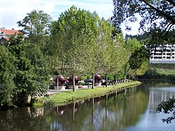
Vouga River (Portuguese pronunciation: [ˈvo(w)ɡɐ]) is a river in the Centro Region of Portugal. The source of the Vouga is the Chafariz da Lapa, at an elevation of 864 metres (2,835 ft), in the parish of Quintela, municipality of Sernancelhe, Viseu District. The course of the river ends in the Atlantic Ocean, in the form of a ria, the Ria de Aveiro.
This article does not cite any sources. (December 2007) |
| Vouga | |
|---|---|
 | |
| Location | |
| Country | Portugal |
| Physical characteristics | |
| Source | Chafariz da Lapa |
| • location | Serra da Lapa, Sernancelhe, Viseu, Portugal |
| Mouth | |
• location | Atlantic Ocean at Aveiro, Portugal |
| Length | 148 km (92 mi) |
| Basin size | 3,635 km2 (1,403 sq mi) |
| Basin features | |
| Tributaries | |
| • right | Caima |
Tributaries
Environment
Cacia pulp and paper mill effluent, one of the major polluting sources of the Vouga River and Aveiro Lagoon, is discharged into the Aveiro coastal area. The area has an unpleasant smell due to the effluent.
На других языках
[de] Rio Vouga
Der Rio Vouga ist ein Fluss in Portugal. Der Fluss entspringt in der Serra da Lapa zwischen Aguiar da Beira und Sernancelhe in einer Höhe von 864 m. Er durchfließt die Região Centro von Osten nach Westen auf einer Länge von 148 Kilometer, bis er bei Aveiro in den Atlantik mündet. Die rechten Zuflüsse sind Caima, Rio Mau und Rio Sul, der einzige linke Zufluss ist der Fluss Rio Águeda.- [en] Vouga River
[it] Vouga
Il fiume Vouga è un fiume del centro del Portogallo.[ru] Вога
Вога (порт. Rio Vouga) — река в центральном регионе Португалии. Берёт исток в Шафариз-да-Лапа, на 864 м высоте над уровнем моря.Текст в блоке "Читать" взят с сайта "Википедия" и доступен по лицензии Creative Commons Attribution-ShareAlike; в отдельных случаях могут действовать дополнительные условия.
Другой контент может иметь иную лицензию. Перед использованием материалов сайта WikiSort.org внимательно изучите правила лицензирования конкретных элементов наполнения сайта.
Другой контент может иметь иную лицензию. Перед использованием материалов сайта WikiSort.org внимательно изучите правила лицензирования конкретных элементов наполнения сайта.
2019-2025
WikiSort.org - проект по пересортировке и дополнению контента Википедии
WikiSort.org - проект по пересортировке и дополнению контента Википедии